Download
1 / 23
230 likes | 337 Views
WisconsinView. US Interagency Elevation. Data. Do you use the WisconsinView collection of county LiDAR ‐derived DEMs? Have you used the site?. Data. Does your organization provide access to LIDAR data? Who can access and by what methods?. Data.

E N D
Data Do you use the WisconsinView collection of county LiDAR‐derived DEMs? Have you used the site?
Data Does your organization provide access to LIDAR data? Who can access and by what methods?
Data How did you/how will you fund LiDAR acquisition?
Data How do we address the inconsistency of vendor deliverables (naming conventions, directory organization, actual deliverables, etc.)?
Data How do we overcome basic data delivery and access hurdles e.g., huge file sizes and other logistical problems?
Data What are the key Objectives of the USGS 3DEP?
Data What data products are you most interested in e.g., LAS or compressed LAZ files, other derived products?
Data What derived products do you typically generate from the LIDAR?
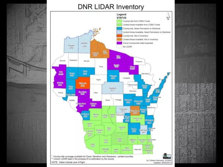
Data What geographic areas does your organization have in its LiDAR data inventory e.g., county, other?
Data What is the best way to share LiDAR data?
Data What other types of data need to be standardized e.g., culvert data needed to take advantage of modeling software, others?
Data What resources would make the LiDAR acquisition process easier for you e.g., standard RFP language; checklist of standards/guidelines; info on what other counties are doing; sample cost estimates; set of quality control standards; other?
Data What LiDAR services are you interested in providing or consuming e.g.,tiledmap services?
Development What applications using LiDAR data need to be considered e.g., elevation data to assist navigation, others?
Development What's the best way to make specialized tools available e.g., Optimized DEM Fill Tool (from Texas, smart for hydro correct DEM, USGS Culvert tool, others )?
Organization Can you recommend how we obtain State & Local ‘buy in’ to better understand the value of LIDAR e.g.,MN and Iowa?
Organization How do you recommend we organize to be more effective e.g., other State/Federal initiatives e.g., MN data Deli, USGS?
Organization What can WIGICC do to help you acquire and/or utilize LiDAR‐derived data more effectively?
Training How can we best establish practical training resources e.g., LiDAR 101 Website, practical training guides?
Training What are your educational needs for LiDAR?