Data Exchange Needs Using ETL Tools
Data Exchange Needs Using ETL Tools. Overview. GIS Project Manager: Kelly Dell. Client Project Issue Methodology Schedule & Budget Results & Recommendations Challenges Acknowledgments Questions. Ministry Of Transportation. Project Issue & Primary Goal.

Data Exchange Needs Using ETL Tools
E N D
Presentation Transcript
Data Exchange Needs Using ETL Tools
Overview GIS Project Manager: Kelly Dell • Client • Project Issue • Methodology • Schedule & Budget • Results & Recommendations • Challenges • Acknowledgments • Questions
Project Issue & Primary Goal • Current data conversion process • Each time data is updated it needs to be redone manually • Need to streamline the process • Extract Transform Load (ETL) Tools • Safe Software Feature Manipulation Engine (FME) • EsriArcGIS GeoprocessingTools (Data Interoperability Extension)
Goals & Deliverables • Streamlined data conversion process • User know-how • ETL tools capabilities and limitations • ETL tool decision making • Final Report and recommendations
Extract Transform Load ETL - Traditional ETL is used to migrate data from one database to another, to form data marts and data warehouses and also to convert databases from one format or type to another. Spatial ETL – Safe Software Feature Manipulation Engine - FME Provides the data processing functionality of traditional ETL, but with a primary focus on the ability to manage spatial data (the geometry, attributes, and coordinate systems of spatial datasets)
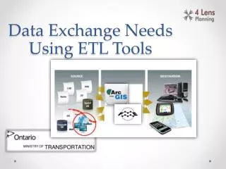
Current Process ArcGIS Desktop MTO MSS ArcSDE Oracle MTO BMS ArcGIS Server Bridge Date xls SQL
FME Server • FME Desktop is the authoring tool for FME Server • Any spatial ETL workflow created in FME Desktop can be published to FME Server • FME Server is a scalable processing environment that allows multiple users via the web • Workflows can be shared and automated in this environment
ArcGIS Desktop Data Interoperability Spatial ETL “Safe Software sets the standard for spatial data interoperability, so it was an obvious choice to use their FME technology for Esri’s ArcGIS Data Interoperability Extension.” – Jack Dangermond, Esri President
Evaluation • Architecture • ETL Functionality • Ease-of-Use • Reusability • Debugging • Real-time • Connectivity • General ETL tool characteristics
Challenges • GIS Expertise, knowledge and training • Assumed licenses acquired and ready to use • Data availability and ability to work on data • Client Representation
Recommendations • Streamlined data conversion process • User know-how • ETL tools capabilities and limitations • ETL tool decision making
Acknowledgements • Client • Laura Kingston • Project Thesis Adviser • Mike Wallace • Technical Advising • Colin Bissell • Jonathan Lepage • Allison Hughes • FME Software Acquisition • Gerry McCoubrey • Craig Vernon