Download
1 / 16
160 likes | 286 Views
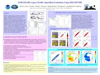
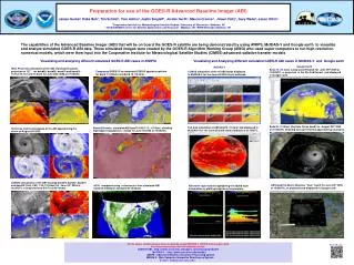
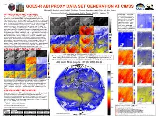
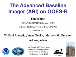
GOES-R ABI AS A WARNING AID Louie Grasso, Renate Brummer , and Robert DeMaria CIRA, Fort Collins, CO Dan Lindsey, Don Hillger , NOAA/NESDIS/RAMMB, Fort Collins, CO High Impact Weather Workshop 8 February 2012, Norman, Oklahoma grasso@cira.colostate.edu. CONTENTS.

E N D
GOES-R ABI AS A WARNING AID Louie Grasso, Renate Brummer, and Robert DeMariaCIRA, Fort Collins, CO Dan Lindsey, Don Hillger, NOAA/NESDIS/RAMMB, Fort Collins, CO High Impact Weather Workshop 8February 2012, Norman, Oklahoma grasso@cira.colostate.edu
CONTENTS Synthetic Real-time GOES-R ABI imagery of the 4 km WRF-ARW at NSSL. Synthetic GOES-R ABI 10.35 Tbs minus 12.3 Tbs and convective initiation. Synthetic GOES-R ABI Natural Color imagery of smoke and ash.
Synthetic Real-time GOES-R ABI imagery of the 4 km WRF-ARW at NSSL.
Synthetic ABI ImagerySynthetic ABI Imagery from NSSL 4 km WRF-ARW • Daily forecasts from NSSL’s 4 km WRF-ARW is used to generate syntheticABI imagery at 3.9, 6.95, 7.34, 8.5, 10.35, and 12.3 µm. • The bands are simulated hourly from the 10 hr to the 36 hr forecast. • Output is provided to the Storm Prediction Center in NAWIPS format, as well as several NWS offices • Channel differencing: 8.5 – 10.35, 8.5 – 12.3, 10.35 – 12.3, and now 3.9 – 10.35. CIRA Synthetic 10.35 µm band valid at 1800 UTC on 1 May 2010, based on an 18-hour forecast from NSSL’s WRF-ARW. The active convection forecast in Tennessee produced devastating flash flooding
Synthetic ABI ImagerySynthetic ABI Imagery from NSSL 4 km WRF-ARW • Synthetic (left) and observed (right) GOES-13 imagery for the 24 April 2010 tornado outbreak. • Synthetic imagery ideal for evaluating the timing of shortwaves in the model, and for low and high cloud forecasts 6.95 µm 6.7 µm CIRA 7.34 µm Sounder 7.5 µm
Real-Time Synthetic NSSL 4km WRF-ARW Imageryon the Web http://rammb.cira.colostate.edu/ramsdis/online/goes-r_proving_ground.asp
2) Synthetic GOES-R ABI 10.35 Tbs minus 12.3 Tbs and convective initiation.
Model Simulations – 27 June 2005 Synthetic Tb(10.35 µm) - Tb(12.3 µm).
3) Synthetic GOES-R ABI Natural Color imagery of smoke and ash.
Synthetic California fire imagery for 23 October 2007 Six hour loop, images every five minutes. CIRA CIRA GOES-11 (GOES-west) Imager band-2 (3.9 μm) GOES-R (at GOES-west location) ABI band-7 (3.9 μm)
Synthetic California fire imagery for 23 October 2007 Six hour loop, images every five minutes. CIRA CIRA GOES-R ABI 10.35 μm GOES-R ABI 11.2 μm
Synthetic California fire imagery for 23 October 2007 Six hour loop, images every five minutes CIRA GOES-R ABI 2.25 μm
Natural color GOES-R ABI image of a smoke plume over southern California from 23 October 2007. The green band was derived from the blue, red, and near IR bands.
Idealized volcanic ash plume included in a27 June 2005 simulation. Modis imagery of the Eyjafjallajökull ash plume was used.
Summary 1) Synthetic Real-time GOES-R ABI imagery of the 4 km WRF-ARW at NSSL. 2) Synthetic GOES-R ABI 10.35 Tbs minus 12.3 Tbs and convective initiation. 3) Synthetic GOES-R ABI Natural Color imagery of smoke and ash. Collaboration Collaborations are always welcome: grasso@cira.colostate.edu