Download
1 / 9
90 likes | 184 Views
Engage in a fun group activity to map out the key features of the Nile River in Egypt. Explore its influence on civilization and the benefits it brings, all while understanding the impact of natural barriers. Be the first to solve it and earn a bonus point!

E N D
Puzzle Time! • With your group, use the puzzle to complete your map • The first group to finish with all correct answers gets a bonus point!
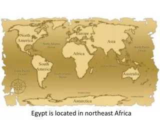
Geography of the Nile River • Flows North • Originates in the highlands of Central Africa • Ends in the Mediterranean Sea • The longest river in the world at 4,160 miles
Floods • Until recently, flooded annually in July • Floods were predictable • Deposited silt, replenishing the soil with nutrients • The silt built up at the mouth of the river, forming a delta
Influence of Geography on Civilization • Natural Barriers provide obstacles to potential invaders • Mediterranean Sea to the North • Libyan Desert to the West • Nubian Desert to the Southeast • Red Sea to the East • Susceptible to Invasion • Across the Sinai Peninsula • Across the Northern Sinai Desert • Also enabled Egypt to invade others
Effect of Barriers • Limited invasions • Limited farming to a narrow region on either side of the Nile River • Caused river villages to be crowded • As population grew, villages expanded • Forced Egyptians to develop irrigation systems to create more fertile land • Drained marshy swamps of the delta region in order to farm the land
Benefits • The river served as a highway • United the villages along the river • The river made travel between villages easy • Currents carried barges downstream • Sails used to catch winds and travel upstream • The river attracted wildlife and fish • Papyrus grew along the river- Used to make paper Nile River Delta from space
Exit Slip • List 5 facts about the Nile River and the physical features of Egypt