Download
1 / 1
10 likes | 98 Views
Explore the application of lunar calibration technique using MTSAT-2 Imager data and compare with ISCCP Calibration Data. Establish a universal lunar calibration equation applicable to GMS, GOES, and METEOSAT for estimating absolute calibration slopes. Future work includes improving the equation with additional calibrated lunar images to enhance accuracy.

E N D
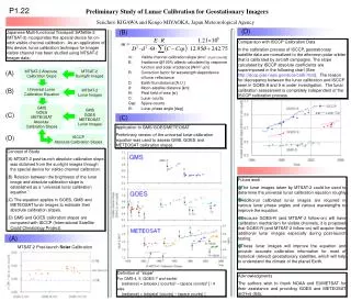
P1.22 Preliminary Study of Lunar Calibration for Geostationary Imagers Seiichiro KIGAWA and Kengo MIYAOKA, Japan Meteorological Agency (D) (B) Japanese Multi-functional Transport SATellite-2 (MTSAT-2) incorporates the special device for on-orbit visible channel calibration. As an application of this device, lunar calibration technique for Imager visible channel has been studied using MTSAT-2 Imager data. Comparison with ISCCP Calibration Data In the calibration process of ISCCP, geostationary satellite data are normalized to the afternoon polar orbiter that is calibrated by aircraft campaigns. The slope calculated by ISCCP absolute coefficients are superimposed in the following chart (See http://isccp.giss.nasa.gov/docs/calib.html). The reason for discrepancy between the lunar calibration and ISCCP seen in GOES-8 and 9 is under investigation. The lunar calibration assessment is completely independent of the ISCCP calibration process. m: Visible channel calibration slope [W/m2 sr μm counts] E: Irradiance @100% albedo calculated by response function and solar irradiance [W/m2μm] R: Correction factor for wavelength-dependence of lunar reflectance D: Earth-Sun distance [A.U.] d: Moon-satellite distance [km] Θ: Pixel field of view [sr] C: Lunar counts Csp: Space counts Θ: Lunar phase angle [deg] MTSAT-2 Sunlight Images MTSAT-2 Absolute Calibration Slope (A) Universal Lunar Calibration Equation (B) MTSAT-2 Lunar Images GMS GOES METEOSAT Absolute Calibration Slopes GMS GOES METEOSAT Lunar Images (C) (C) Application to GMS/GOES/METEOSAT Preliminary version of the universal lunar calibration equation was used to assess GMS, GOES and METEOSAT calibration slopes. (D) ISCCP Absolute Calibration Slopes • Concept of Study • MTSAT-2 post-launch absolute calibration slope was obtained from the sunlight images through the special device for visible channel calibration. • Relation between the brightness of the lunar image and absolute calibration slope is established as a “universal lunar calibration equation.” • The equation applies in GOES, GMS and METEOSAT lunar images to estimate their absolute calibration slopes. • GMS and GOES calibration slopes are compared with ISCCP (International Satellite Could Climatology Project). • Future work • The lunar images taken by MTSAT-2 could be used to determine the universal lunar calibration equation roughly. • Additional calibrated lunar images are required in various lunar phase angles and various wavelengths to improve the equation. • Because GOES-R (and MTSAT-2 follow-on) will have calibration mechanism for visible channels, it is proposed that GOES-R (and MTSAT-2 follow-on) will acquire these additional lunar images especially during post-launch testing. • These lunar images will improve the equation and provide accurate calibration information for most of historical (retired) geostationary satellites, which will help to understand the climate of the planet Earth. (A) MTSAT-2 Post-launch Solar Calibration Definition of “slope” For GMS-4, 5, GOES-7 and earlier (radiance) = (slope)x [ (counts)2 – (space counts)2 ] / 4 else (radiance) = (slope)x[ (counts) – (space counts) ] Acknowledgments The authors wish to thank NOAA and EUMETSAT for their assistance and providing GOES and METEOSAT archive data.