Download
1 / 7
70 likes | 154 Views
Plan to monitor contaminant flow in water bodies, assess remedial efforts, and ensure regulatory compliance at key locations. Snapshotting effects on wetlands and establishing compliance points. Flow and chemistry monitoring to evaluate loadings and sources.

E N D
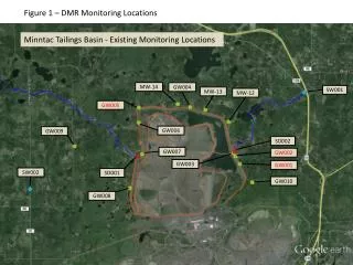
Figure 1 – DMR Monitoring Locations Minntac Tailings Basin - Existing Monitoring Locations MW-14 GW004 SW001 MW-13 MW-12 GW005 GW006 GW009 SD002 GW007 GW002 GW003 GW001 SW002 SD001 GW010 GW008
Figure 2 – West Side SOC Sampling Locations Dark River SOC Monitoring Locations Dark R – Designated Trout Stream Dark R at CH 65 (D-1A) Dark R at CR 668 (D-1)
Figure 3 – East Side SOC Sampling Locations Lack of flow data makes it difficult to determine where mass is entering the system Twin 2 Twin 4 PZ 7S, D PZ 6S, D Twin 3 PZ 5S, D Twin 1 PZ 4S, D PZ 12S, I, D PZ 2 PZ 3
Data Needs • Determine compliance with applicable WQS at key locations • Monitor to determine where contaminants are leaving tailings basin, and where they’re headed • Monitor locations where effectiveness of remedial efforts can be assessed • Screening to assess the current impact to surrounding wetlands and water bodies – Establish Snapshots
Figure 4 – Proposed WQ Permit Compliance Points Little Sandy Lake Inflow MW-14 MW-13 Dark R at CR668 MW-12 Proposed Property Boundary Well Headwaters of Dark R Admiral Lake Outflow Timber Creek
Figure 5 – Possible Flow of Seeps to Timber Creek Timber Creek Possible Aggregate Seepage Compliance Point
Flow and Chemistry Monitoring to Evaluate Sources of Loadings to Twin Lakes Inflow to Sandy L. from Little Sandy L. Inflow to Little Sandy Lake SCRS Sheet Pile Admiral Lake Outflow to Sand River