Download
1 / 27
270 likes | 431 Views
Unit 5-3: Plate Tectonics - History, Evidence, and Boundaries. The basis of plate tectonics. The idea of lithospheric plates is not new. When accurate maps were made in the 17 th century, people began to notice similarities between the shapes of continents.

E N D
Unit 5-3:Plate Tectonics - History, Evidence, and Boundaries
The basis of plate tectonics • The idea of lithospheric plates is not new. • When accurate maps were made in the 17th century, people began to notice similarities between the shapes of continents. • This gave rise to the theory of continental drift. • Prior to this, it was believed that the continents were completely stationary, and had been since the beginning of time!
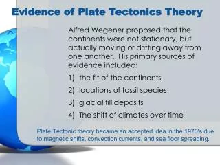
The basis of plate tectonics • The theory of continental drift, the basis of plate tectonics, was developed in part by Alfred Wegener. • It was found that Africa and South America have very similar shaped coasts. • It was postulated that they could have been one continent at one point. • Wegener found that there were the same fossils of Mesosaurus on both continents • near the coasts none the less! • This dinosaur is not found anywhere else in the world by the way.
The basis of plate tectonics • Wegener’s theory was hotly debated for many years • It was accepted in the late 1950’s. • As more evidence, such as earthquake and volcano locations, came to light, Wegener’s theory of continental drift took a new form: • Plate Tectonics
More evidence for plate tectonics • Magnetism • Some rocks and minerals are inherently magnetic, like magnetite. • When these rocks form, they make a record of the Earth’s magnetic field. • When scientists look at the rocks in the crust, they can determine the direction and strength of the Earth’s magnetic field.
When magma rises and cools, it locks in the magnetic field. When the field changes, the recently cooled rock reflects that change. This reversal is shown over and over again.
More evidence for plate tectonics • When scientists turned their attention to the sea floor, especially the Mid-Atlantic Ridge, they found something amazing. • The Earth’s magnetic field has changed it direction! • Scientists found that the magnetic field has shifted no less than 4 periods of normal and reversed polarity in the past 4 million years.
More evidence for plate tectonics • In addition to the changes in magnetism, • Scientists found that the youngest rocks are at the center of the Mid-Atlantic Ridge, • And the oldest rocks are farthest away! • This is clear evidence of a spreading plate boundary, called a spreading center, where material is rising from the astenosphere and making is way into the Earth’s crust.
More evidence for plate tectonics • There has also been evidence that supports the convection current model. • Heat flow is a measure of the heat leaving the rocks of the lithosphere. • Scientists have found very high heat flow in rocks near spreading centers • This heat flow decreases the further you get from the spreading center.
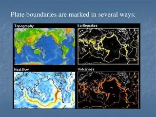
Plate Boundaries • There are several kinds of plate boundaries. • Plate boundaries are determined by the direction each plate is travelling. • One plate is likely to have at least two if not all of the different types of boundaries.
Plate Boundaries • Diverging boundary: • This is where material is pushed up from the astenosphere and joins the lithosphere. • The Mid-Atlantic Ridge is an example of a diverging boundary. • These are made where the two plates move apart from each other. • These commonly have a rift valley: • Where a mountain range is created by upwards moving material that spread apart and creates a valley between them.
Material from the mantle pushes up between the two plates, pushing them apart. As time progresses, more material rises, pushing the plates farther apart. Eventually, an ocean can form between them if enough time passes.
Plate Boundaries • Sliding Boundaries: • This type of boundary occurs where the lithospheric plates are sliding past each other, not at or away from each other. • The famous example is the San Andreas Fault in California. • A fault is a break or crack in the Earth’s Crust • The San Andreas Fault moves about 5cm per year. • Some areas have not moved in many years, they are likely to have an earthquake.
A sliding, or transform boundary is indicated by the two plates pushing past each other. If they slide suddenly, then a earthquake will occur.
The San Andreas Fault There, I fixed it!
Plate Boundaries • Convergent Boundaries: • This type of boundary occurs where two continental plates are moving directly at each other. • This causes mountain ranges to form as the land is pushed upwards. • The Himalayas in India and China are a result of a convergent boundary. • India moves about 5cm per year towards China, slowly increasing the height of the mountains. • This also causes earthquakes.
Plate Boundaries • Convergent boundaries may also have resulted in some mountain ranges in the past. • The Southern Appalachian Mountains in North America may have been created when the North American and the African plates collided many millennia ago. • They have since separated and allowed the Atlantic Ocean to form.
Mountains are built up as the plates collide, the material has to go somewhere! The other plate sinks into the earth, melts, and becomes magma once more!
Plate Boundaries • Subduction Boundaries: • Occurs when two ocean plates or an ocean plate and a continental plate collide. • One plate is forced under the other and is driven deep into the Earth. • A characteristic of this type of boundary is a deep-sea trench where the two plates meet. • Depending on the types of plates colliding, there are different features.
Plate Boundaries • Subduction Boundaries: • A collision between two ocean plates will result in: • Deep-sea trench • Volcanic islands • A collision between an oceanic plate and a continental plate will result in: • A mountain chain on land (rarely volcanoes) • A deep-sea trench
When at least one ocean plate converges on another plate, a subduction boundary is seen. When an oceanic plate subducts below a continental, a volcano chain will likely form. If two ocean plates collide, there is a possibility for a mid-ocean volcano.