Download
1 / 14
140 likes | 246 Views
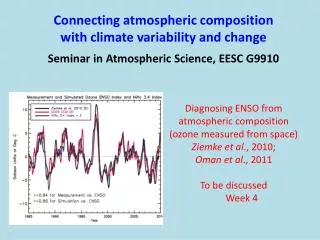
Polar Atmospheric Composition: Some Measurements and Products A Report on Action item STG3-A11. Jeff Key NOAA/NESDIS. Clouds. AVHRR Polar Pathfinder extended (APP-x). Based on the NOAA/NASA AVHRR Polar Pathfinder data set from NSIDC :

E N D
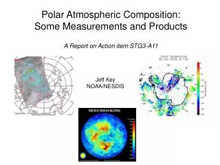
Polar Atmospheric Composition: Some Measurements and Products A Report on Action item STG3-A11 Jeff Key NOAA/NESDIS
AVHRR Polar Pathfinder extended (APP-x) • Based on the NOAA/NASA AVHRR Polar Pathfinder data set from NSIDC : • Time period : 1982 – 2004, 0400 & 1400 local solar time. • Spatial scale : 5 km, subsampled to 25 km over the entire Arctic and Antarctic • Near real-time (once-daily) processing also running • Parameters: • Surface temperature and albedo • Cloud amount, phase, optical depth, particle size, temperature, pressure • Surface and top-of-atmosphere shortwave and longwave fluxes; cloud forcing
NOAA’s Operational AVHRR Cloud Product • While advanced imagers such as VIIRS and ABI will provide significantly improved cloud remote sensing capabilities, the data from AVHRR and the GOES imagers provide our best current real-time cloud observing system from imager data. • The Clouds from AVHRR Extended System (CLAVR-x) derives cloud properties from the AVHRR that are physically similar to those from MODIS, VIIRS and ABI and provide valuable experience to NOAA’s customers that should increase the usage of cloud products during NPOESS and GOES-R. • Similar algorithms to those used in CLAVR-x are run on GOES imager data and provide a consistent suite of cloud products to NOAA’s customers at multiple spatial and temporal resolutions. Example CLAVR-x Product at 55 km Example CLAVR-x Product at 1 km
AVHRR Pathfinder Atmospheres Extended (PATMOS-x) • PATMOS-x is continuation of the NESDIS PATMOS program in the 1990’s. The AVHRR is relevant sensor for climate given its long record, consistent spectral coverage and improving calibration. • PATMOS-x offers new products at a higher resolution from improved data. Where PATMOS only offered cloud amount, PATMOS-x provides a full suite of cloud properties and selected clear-sky products. • PATMOS-x products were developed to be physically consistent with those from EOS/MODIS. We are trying to achieve same consistency with NPOESS/VIIRS. • PATMOS-x leverages heavily off of the development efforts already funded for real-time product generation (i.e. CLAVR-x) • PATMOS-x speaks directly to the NOAA mission of Climate Variability Example Year to Year Variation in High Cloud Amount from PATMOS-x (Andy Heidinger)
Metop AVHRR Operational Clouds from NESDIS • The Advanced Very High Resolution Radiometer (AVHRR) on Metop, launched October 2006, provides global 1km data for the first time from an operational sensor. • The Clouds from AVHRR Extended (CLAVR-x) processing system can generate 1 km cloud products (detection, type, height, and optical properties). • CLAVR-x transitioned to operational status in May 2007. • Since then, global 1 km cloud properties have been produced operationally and made available to NESDIS customers. • The images on the left show were generated from CLAVR-x output for August 2, 2006 from METOP-A FRAC data over Europe. • The image on the left shows a false image using the 0.63, 0.86 and 11 mm observations. • The image on the right shows the cloud optical depth. Values greater than 20 are shown as red. Small values are blue. • Work is ongoing with EUMETSAT on METOP product validation and inter-comparison. False Color Image using 0.63, 0.86 and 11 mm observations from METOP-A Derived Cloud Optical Thickness from CLAVR-x (Andy Heidinger)
MODIS Cloud Products – Direct Broadcast and Archived In theory, the MODIS cloud detection scheme is more robust than that for AVHRR, given more spectral information with MODIS.
Atmospheric Composition and Aerosol Measurements • Bromine (BrO) from OMI (on Aura) and GOME-2 (on MetOP) • Total column ozone and NO2 from OMI (Aura) and GOME-2 (MetOP) (daytime) • Tropospheric O3 and CO profiles from the Tropospheric Emission Spectrometer (TES) • Tropospheric O3 and CO profiles from AIRS (Terra) • Total column CO from MOPITT (Terra) and IASI (Metop) • Stratospheric and upper tropospheric O3, CO, ClO, HCl, HNO3 and SO2 profiles from the Microwave Limb Sounder (MLS) (Aura) • Stratospheric O3, NO2, and aerosol extinction from Optical Spectrograph and Infrared Imager System (OSIRIS) on the Canadian ODIN satellite • A suite of molecules (including O3,CH4,N2O,NO2,NO,HNO3,HCl,HF,CO) from the Atmospheric Chemistry Experiment (ACE) FTS onboard the Canadian SCISAT-1 satellite • Stratospheric O3 profiles from SBUV2 (daytime) • Total column measurements of O3, NO2, OC1O, H2CO, Br0 from SCIAMACHY on ENVISAT • Stratospheric profile measurements of O3, NO2, BrO, H2O, N2O,CO, CH4 from SCIAMACHY on ENVISAT. • Aerosol attenuated backscatter from CALIPSO • Aerosol Optical Depth from MODIS and MISR (daytime, no ice/snow)
Total vertical column bromine (BrO) observations from OMI (on Aura) and GOME-2 (on MetOP) for 23:59Z and 15:30Z (24-hr averages) on April 8, 2008. Arctic boundary layer BrO enhancements lead rapid ozone loss within the Arctic boundary layer. OMI data provided by Thomas Kurosu, Harvard-Smithsonian Center for Astrophys. GOME-2 data provided by Trevor Beck, NOAA/NESDIS
Polar Winds from MODIS and AVHRR MODIS: bent-pipe, MODIS direct broadcast, Terra & Aqua separately and combined; AVHRR: GAC, HRPT, NOAA & MetOp (with EUMETSAT) satellites; historical GAC
Soundings from TOVS Path-P • Arctic TOVS-derived Level-3 atmospheric parameters are obtained using a physical-statistical retrieval method, improved for use in sea ice-covered areas (J. Francis). Parameters: • Air temperature • Effective cloud amount/frequency • Cloud top pressure • Cloud top temperature • Cloud emissivity • Precipitable Water • Skin temperature • Surface air temperature • Wind stress • Period: • NH: 1979 – 2005 • SH: 1979 – 2001 • (no retrievals for land > 1000 m elev)
Hyperspectral Global Soundings Global hyperspectral atmospheric soundings are available from NASA’s AIRS instrument and EUMETSAT’s IASI. These should improve soundings in the polar regions, particularly in the lower troposphere where temperature inversions are common. NAST-I spectrum over Oklahoma, 3 March 2000.