Overview of St. Cloud Urbanized Area and I-94 West Corridor Development Plans
This document provides a comprehensive overview of the St. Cloud Urbanized Area, with a population of 111,000 as per the 2010 census, and the I-94 West Corridor extending to the Brainerd Lakes Region. It highlights existing traffic patterns, AADT statistics, and growth potential in Central Minnesota’s MnDOT District 3. It also discusses congestion levels, safety issues, tourism impacts, and freight considerations along this vital transportation corridor. Additionally, future MnDOT plans for capacity improvements and new river crossings are outlined.

Overview of St. Cloud Urbanized Area and I-94 West Corridor Development Plans
E N D
Presentation Transcript
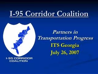
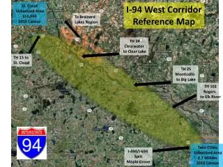
St. Cloud Urbanized Area 111,000 2010 Census I-94 West Corridor Reference Map To Brainerd Lakes Region TH 24 Clearwater to Clear Lake TH 15 to St. Cloud TH 25 Monticello to Big Lake TH 101 Rogers to Elk River Twin Cities Urbanized Area 2.7 Million 2010 Census I-494/I-694 Split Maple Grove
Central Minnesota MnDOT District 3 “ATP” Growth Source: MnDOT
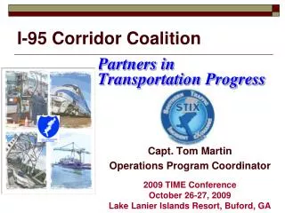
St. Cloud Urbanized Area 111,000 2010 Census I-94 West Corridor Existing Traffic(Source: MnDOT) To Brainerd Lakes Region 39,500 AADT Clearwater TH 24 Mississippi River Crossover to TH 10 TH 15 to St. Cloud 42,000 AADT TH 25 Monticello to Big Lake TH 101 Rogers to Elk River 53,000 AADT 63,000 AADT Note: 60,000 ADT: 4 Lane Freeway Capacity 100,000 ADT: 6 Lane Freeway Capacity 95,000 AADT 114,000 AADT Twin Cities Urbanized Area 2.7 Million 2010 Census I-494/I-694 Split Maple Grove
I-94 West Corridor IRC Performance (Source: MnDOT) St. Cloud Urbanized Area 111,000 2010 Census I-94 from TH 241 in St. Michael to TH 23 in St. Cloud has 40 percent of the congestion on MnDOT’s Interregional Corridor (IRC) system, yet accounts for only 1.6 percent of this system. Twin Cities Urbanized Area 2.7 Million 2010 Census
St. Cloud Urbanized Area 111,000 2010 Census I-94 West Corridor Peak Period Congestion (Source: National Highway System, FHWA) 2007 2040 Twin Cities Urbanized Area 2.7 Million 2010 Census
St. Cloud Urbanized Area 111,000 2010 Census I-94 West Corridor Safety (Source: MnDOT) Twin Cities Urbanized Area 2.7 Million 2010 Census
St. Cloud Urbanized Area 111,000 2010 Census I-94 West Corridor Tourism (Source: Explore Minnesota) Twin Cities Urbanized Area 2.7 Million 2010 Census
St. Cloud Urbanized Area 111,000 2010 Census I-94 West Corridor Freight (Source: MnDOT) Twin Cities Urbanized Area 2.7 Million 2010 Census
I-94 West Corridor MnDOT Plans(Source: MnDOT) • MnDOT I-94 Interregional Corridor Plan (2002) • 10 Lanes to Rogers; 8 Lanes to Monticello; 6 Lanes to Clearwater • MnDOT I-94/TH 10 Interregional Mississippi River Crossing EIS (2006) • New Freeway connection from I-94 to TH 10 in Clearwater/Clear Lake Area • MnDOT District 3 State Highway Investment Plan 2009-2028 (2009) • 6 Lanes from Rogers to Clearwater • I-94/TH 10 New Mississippi River Crossing from Clearwater to Clear Lake • MnDOT Central Minnesota Regional Freight Study (2011) • Capacity Improvements Along I-94 in Central Minnesota • I-94/TH 10 New Mississippi River Crossing from Clearwater to Clear Lake • I-94 Truck Traffic From North Dakota to Twin Cities to be “Highly Congested” by 2040 Draft MnDOT “MnSHIP: 2014-2033” (Final Plan Due in 2013) ?