Download
1 / 22
220 likes | 375 Views
MODIS Land Rapid Response Project. Jacques Descloitres 1 , Rob Sohlberg 2 , John Owens 2 , Louis Giglio 1 , John Seaton 3 , Mark Carroll 4 , Missy Crisologo 2 Chris Justice 2 , Ed Masuoka 5 Mark Finco 6 , Keith Lannom 6 , Tom Bobbe 6. 1 NASA/GSFC Science Systems and Applications, Inc.

E N D
MODIS Land Rapid Response Project Jacques Descloitres1, Rob Sohlberg2, John Owens2, Louis Giglio1, John Seaton3, Mark Carroll4, Missy Crisologo2 Chris Justice2, Ed Masuoka5 Mark Finco6, Keith Lannom6, Tom Bobbe6 1NASA/GSFC Science Systems and Applications, Inc. 2University of Maryland, Department of Geography 3NASA/GSFC Science Applications International Corporation 4University of Maryland, Institute for Advanced Computer Studies 5NASA/GSFC Code 922 6U.S.D.A. Forest Service Remote Sensing Applications Center The MODIS Rapid Response Project – J. Descloitres – 12/19/01
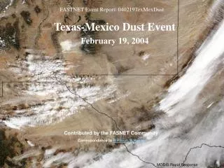
Background • The complexity of the ECS production and distribution system does not always permit rapid access to MODIS data – System contingencies may significantly delay data availability • The most optimistic data turnaround is acceptable for some but not all applications: Level-1B data not available earlier than 24-48hrs, Level-2 available 1 week later, Level-3 composite products 8/16 days later • Rapid data access is most critical at least in two areas: active fire detection and PR imagery • Manual workarounds have been developed in 2000 to provide rapid PR imagery to the Earth Observatory in response to specific events • Expedited active fire information derived from MODIS was handcrafted and provided to the Forest Service to document fires in Montana/Idaho during summer 2001 The MODIS Rapid Response Project – J. Descloitres – 12/19/01
Approach • To develop a rapid,flexible, and streamlined processing and distribution user-driven system with global coverage to meet users needs with respect to rapid access to MODIS data • To provide enhanced PRand outreach for some of the unique capabilities of MODIS • To generate value-added science-quality products to augment the MODIS standard products – Initial emphasis on combined Active Fire Detection / Corrected Reflectance product • To reuse existing software, hardware and expertise (e.g., ESIP-funded MODIS 250m Production System, MODIS Land Global Browse Processing System) • To develop applications partnerships with other agencies to utilize the data and gain recognition and support for EOS (e.g., U.S.D.A. Forest Service) The MODIS Rapid Response Project – J. Descloitres – 12/19/01
Design • Processing developed at NASA/GSFC using MODIS Level-0 data from NOAA (using existing “bent pipe” feed mechanism used to generate weather products) • L0 data processed with IMAPP software (DAAC processing code modified for Direct Broadcast applications) • Geolocation derived from spacecraft attitude data – No FDS definitive attitude • No real-time ancillary data necessary • Processing system 100% automated – No operator • Corrected reflectance and active fire locations produced within 2-5hrsof data acquisition and automatically sent to Rapid Response distribution site and to partners The MODIS Rapid Response Project – J. Descloitres – 12/19/01
Terra USDA Forest Service Remote Sensing Application Center Direct Broadcast Receiving Station EDOS NOAA University of Maryland Geography Dept Rapid Response System NASA/GSFC GES DAAC NASA/GSFC L1B Data MODIS Rapid Response Project: Design December 2001 T+30min Cumulative Fire Maps http://www.fs.fed.us/eng/rsac Backup Feed L1B Data Daily 6am MST Active Fire Locations Burn Severity Maps Handcrafted Imagery T+5hrs Active Fire Locations Selected Imagery Active Fire Locations GOFC Fire Partners MODIS L0 Data T+2-5hrs T+5hrs Active Fire and Corrected Reflectance http://rapidfire.sci.gsfc.nasa.gov NASA Earth Observatory http://earthobservatory.nasa.gov MODIS home page http://modis.gsfc.nasa.gov Web Fire Maps and Fire Feature Server http://rapidresponse.umd.edu The MODIS Rapid Response Project – J. Descloitres – 12/19/01
Distribution Approach • RGB imagery with Active Fire overlay is archived and distributed to the public by the Rapid Response System at NASA/GSFC • Near-real-time imagery: http://rapidfire.sci.gsfc.nasa.gov/production/ (full production) • Selected handcrafted imagery: http://rapidfire.sci.gsfc.nasa.gov/gallery/ • On-line archive – No ordering interface • Straightforward “point-and-click” web interface • Application-specific products distributed by partners (e.g., web fire maps by University of Maryland, cumulative fire maps by Forest Service) • Privileged relationship developed with selected science image publishers to increase product visibility: Earth Observatory, Visible Earth, MODIS home page, Science Visualization Studio The MODIS Rapid Response Project – J. Descloitres – 12/19/01
Example of Active Fire / Corrected Reflectance ProductStar fire in California (08/29/01) The MODIS Rapid Response Project – J. Descloitres – 12/19/01
Example of Active Fire / Corrected Reflectance ProductSiberia (05/22/01) The MODIS Rapid Response Project – J. Descloitres – 12/19/01
Example of 250m Corrected Reflectance ProductHurricane Erin (09/11/01) The MODIS Rapid Response Project – J. Descloitres – 12/19/01
Example of Corrected Reflectance ProductDust Storm in Western Africa (05/08/01) The MODIS Rapid Response Project – J. Descloitres – 12/19/01
Example of 250m Corrected Reflectance ProductBrazil/Bolivia (08/02/01) The MODIS Rapid Response Project – J. Descloitres – 12/19/01
Example of 250m Vegetation IndexRondonia, Brazil (08/02/01) The MODIS Rapid Response Project – J. Descloitres – 12/19/01
Example of 250m Corrected Reflectance ProductLake Michigan (09/11/01) The MODIS Rapid Response Project – J. Descloitres – 12/19/01
MODIS Rapid Response Products used by Fire Managers • MODIS provides a new synoptic view at high resolution and gives the “big picture” to planners for resource allocation • Remote sensing avoids limitations of airborne platforms (heavy smoke, limited flight resources, limited geographic coverage) • Helps focus reconnaissance resources and prepare rehabilitation work on the ground USFS Remote Sensing Applications Center (Salt Lake City, Utah): Provider of geospatial and remote sensing support to USFS and related agencies National Interagency Fire Center (Boise, Idaho): National coordination center for all federal and state wildfire resources USFS Fire Science Lab, Rocky Mountain Research Station (Missoula, Montana): Smoke forecasting and fire behavior research Burned Area Emergency Rehabilitation Teams: Federal inter-agency program to mitigate impacts on water quality and ecology The MODIS Rapid Response Project – J. Descloitres – 12/19/01
The MODIS Rapid Response Project – J. Descloitres – 12/19/01
Blue Complex Fire16 August 2001 Oregon California Nevada Active Fire in REDPreviously Burned in YELLOW The MODIS Rapid Response Project – J. Descloitres – 12/19/01
Idaho/Montana 2000 Wildfire Vegetative Cover Conversion Alarm Result in Red 25km 25km 25km July 24th September 26th VCC VCC identified the land cover change resulting from the Wilderness Complex, Valley Complex, Diamond Creek, and Clear Creek wildfires. The MODIS Rapid Response Project – J. Descloitres – 12/19/01
MODIS Rapid Response Systemand Direct Broadcast Applications • Science products developed to support both DAAC Level-1 data and Direct Broadcast Level-1 data • Rapid Response processing progressively transitioned to Direct Broadcast • Preliminary test and packaging work initiated in August 2001 with Direct Readout Lab at NASA/GSFC • First field implementation prototyped in December 2001 with USDA Forest Service • Standard Rapid Response products generated within minutes of acquisition • Code sharing approach: ongoing effort to make Rapid Response processing available to Direct Broadcast users • Effort to standardize existing Direct Broadcast Level-1 processing softwares The MODIS Rapid Response Project – J. Descloitres – 12/19/01
Accomplishments • Developed a system to provide quality imagery and active fire information from MODIS within hours of acquisition • Demonstrated feasibility of science data system rapid prototyping – a few months to “operational” status • Demonstrated new, easy access approaches for EOS data distribution • Filled a large gap in existing data system capabilities with a flexible, responsive system • Made available new NASA data to disaster management users and the public • 400+ images ingested into Visible Earth database • Developed active collaboration with new MODIS data users in other federal agencies (USFS/NIFC) • Major contribution to international GOFC fire The MODIS Rapid Response Project – J. Descloitres – 12/19/01
Future Development • Finalize software transition to Direct Broadcast • Streamline image generation process for rapid publication (press) • Consider expanding geographic coverage (oceans) • Investigate feasibility of new rapid products: vegetation index, burn severity, smoke index, fire risk, flood monitoring • Developing new partnerships (e.g., crop forecasting and food security application with U.S.D.A. Foreign Agricultural Service) • Explore transition to operational agency (NOAA/NESDIS) • Explore collaboration with U.S. Air Force The MODIS Rapid Response Project – J. Descloitres – 12/19/01
Satellite Week Positive Media Coverage for All Partners Plus 40 stations which ran the NASA-TV video file. The MODIS Rapid Response Project – J. Descloitres – 12/19/01
For more information http://rapidfire.sci.gsfc.nasa.gov http://rapidresponse.umd.edu The MODIS Rapid Response Project – J. Descloitres – 12/19/01