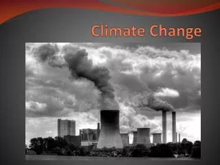
Understanding Climate Change Impacts and Projections
Explore the evidence of climate change and its impacts on Earth’s temperature, glaciers, sea ice, and hydrology. Learn about climate change scenarios, adaptation options, and projections for the future.

Understanding Climate Change Impacts and Projections
E N D
Presentation Transcript
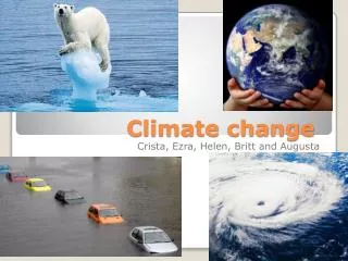
Climate Change Bill Taylor
The Intergovernmental Panel on Climate Change (IPCC) “The work of the…IPCC represents the consensus of the international science community on climate change science. We recognize IPCC as the world’s most reliable source of information…and endorse its method of achieving this consensus.” Joint statement by Academies of Science – May 2001 www.ipcc.ch
Part 1Evidence of climate change Is the climate changing?
www.studyworksonline.com deschutes.gso.uri.edu/ www.studyworksonline.com Earth’s temperature record Proxy record Instrumental record
Global Data from thermometers Variations in the Earth’s surface temperature for the past 140 years Source: IPCC Third Assessment Report, 2001
Departures in temperature (°C) from the 1961-1990 average Variations in the Earth’s surface temperature for the past 1000 years (N. Hemisphere) Data from thermometers (red)and fromtree rings, corals, ice cores and historical records (blue). Source: IPCC Third Assessment Report, 2001
Temperature trends in Canadaannual -from 1950–1998 Daily Minimum Units are degrees C per 49-year period. Gridsquares with trends statistically significant at 5% are marked by crosses. Source: Zhang et al, 2000
Trends in daily minimum temperatureseasonal -from 1950–1998 Units are degrees C per 49-year period. Gridsquares with trends statistically significant at 5% are marked by crosses. Source: Zhang et al, 2000
20th Century warming in Southern Canada • Temperature increase of 0.9° C per century • Canada has become “less cold” • Canada is wetter • Shifts in snow fraction • Large regional differences • Large seasonal differences Source: Zhang et al, 2000
Part 2Physical evidence Visible changes?
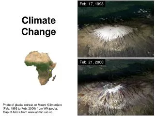
Glaciers in retreat Source: IPCC, Third Assessment Report, 2001
Sea-ice extent and thickness • Northern Hemisphere • 10% reduction in sea-ice extent during spring and summer • 40% reduction in Arctic sea-ice thickness Source: Vinnikov et al, 1999 Source: IPCC, Third Assessment Report, 2001
Snow-cover extent and duration • Changes in Northern Hemisphere in 20th Century • 10% reduction in snow cover extent since late ‘60s • 2 week reduction in duration of lake and river ice cover Source: IPCC, Third Assessment Report, 2001 Source: R. Brown, Environment Canada
Part 3Impacts on hydrology Vulnerability to climate change?
Climate change scenarios Hydrologic modeling (water supply) Agricultural modeling (water demand) Adaptation Options- (cost/benefit; stakeholder dialogue) Water Management & Climate Change in the Okanagan – CCAF Project Supported by a grant from the Climate Change Action Fund (#A463/433), Natural Resources Canada, Ottawa.
Okanagan Agriculture • Wine industry • ~$200 million sales • Tourism • Tree fruit • $67 million sales (apples = $43 million) • % change in area grown 1996-2001 • Apples -20% • Grapes +193% Source: (1) BC Wine Institute (2) BC Ministry of Agriculture, Food and Fisheries (2001 data)
Irrigation “Agricultural sustainability in these semi-arid regions is primarily determined by water supply being adequate to meet demand.” (Denise Nelisen, PARC) Summerland Courtesy: David Sellers, consultant
Crop Water Demand • Amount of water required depends on • Crop coefficients (ET) • Length of growing season (growing degree days) • Area x usage for each polygon • Summed over all polygons Indicator: daily maximum temperaturein growing season
Water supply (Snow Pack) • Supply of water during growing season depends on accumulation of snow during winter • Indicators: • Snowpack (SWE) • Winter and spring temperature • Snow fraction
Trends in Daily Maximum Temperature 0.024 ºC per year 0.012 ºC per year 0.010 ºC per year 0.013 ºC per year Daily Maximum Temperature - Summerland
Trends in snow fraction • SF = portion of precipitation that falls as snow • Based on Nov-Mar snow and precip • Differences in elevation • McCulloch – 1250m • Penticton – 344m
Trends in snow pack • April 1 SWE • Declines at some stations • Elevation? • Warmer springtime! 1780 m 1280 m
Onset of snow-melt • = Date of Tavg > 0 • Based on Daily Average Temperature at McCulloch (1250m) • Advance of 11 days over 45 years (11 +/- 4 days)
Part 4Climate change projections How will climate change in future?
Causes of climate change • Natural factors • Solar variability • Volcanic dust • Internal variability (ENSO, PDO) • Human factors • - Greenhouse gases • - Aerosols • - Ozone depletion • - Land use change
5.8° 1.4° Global temperature response to SRES scenarios Source: IPCC, Third Assessment Report, 2001
Unprecedented warming! Source: IPCC Third Assessment Report, 2001
Climate Change Scenarios for 50 °N, 120°W for the 2050s
Impacts on Water Supply • Reduction in snow pack • More rain dominated hydrograph • Change in volume and timing of peak flows Snow Water Equivalent Stream Discharge Source: Wendy Merritt & Younes Alila, UBC – UBC Watershed Model results
Basin crop water use in response to climate change Source: Denise Neilsen, PARC, Ag. Canada, Summerland
Costs and Benefits of Adaptation Options in the Okanagan • Demand-side management options • Public education (10%) • Irrigation scheduling (10%) • Drip irrigation (30%) • Leak detection (10 to 15%) • Domestic water metering (20 to 30%) • Supply-side options • Lake pumping (up to 100%) • Increase storage (limited) Costs range from $1,000 to $2,000 per acre-foot