Dataset Annotation Graphical Notation
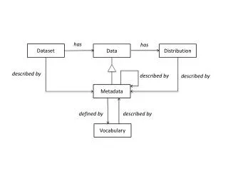
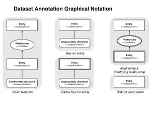
Dataset Annotation Graphical Notation. Entity <<observation>>. Entity <<observation>>. Entity <<observation>>. Relationship <<context>>. Characteristic ( Standard ) <<measurement>>. Relationship <<context>>. Key for entity. Entity <<observation>>. Entity <<observation>>. Entity

Dataset Annotation Graphical Notation
E N D
Presentation Transcript
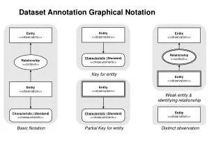
Dataset Annotation Graphical Notation Entity <<observation>> Entity <<observation>> Entity <<observation>> Relationship<<context>> Characteristic (Standard) <<measurement>> Relationship<<context>> Key for entity Entity <<observation>> Entity <<observation>> Entity <<observation>> Weak entity & identifying relationship Entity <<observation>> Characteristic (Standard) <<measurement>> Characteristic (Standard) <<measurement>> Basic Notation Partial Key for entity Distinct observation
Annotations … • PLT-GCED-0409 “Plant community response to fertilization …” http://knb.ecoinformatics.org/knb/metacat/knb-lter-gce.190.7/knb • PLT-GCEM-0211b “Plant allometry at GCE sampling sites …” http://knb.ecoinformatics.org/knb/metacat/knb-lter-gce.27.17/knb • PLT-GCEM-0511a “Fall 2005 plant monitoring survey -- plant height and shoot status …” http://knb.ecoinformatics.org/knb/metacat/knb-lter-gce.266.6/knb • PLT-GCEM-0511b “Fall 2005 plant monitoring survey -- biomass calculated from plant height and shoot status …” http://knb.ecoinformatics.org/knb/metacat/knb-lter-gce.267.16/knb • INV-GCEM-0501a1 “Mollusc population abundance monitoring …” http://knb.ecoinformatics.org/knb/metacat/knb-lter-gce.234.6/knb • INV-GCEM-0501a2 “Mollusc population size distribution monitoring …” http://knb.ecoinformatics.org/knb/metacat/knb-lter-gce.235.7/knb • INV-GCEM-0511 “Fall 2005 crab monitoring: mid-marsh and creek bank abundance …” http://knb.ecoinformatics.org/knb/metacat/knb-lter-gce.265.16/knb • INS-GCEM-0511 “Fall 2005 grasshopper monitoring -- mid-marsh grasshopper abundance …” http://knb.ecoinformatics.org/knb/metacat/knb-lter-gce.273.6/knb
PLT-GCED-0409.1.1Plant community response to fertilization at Sapelo Island, Georgia • Attributes • Site • Community • Treatment • Replicate • Species_Code • ITIS_TSN • Plant_Mass • Plant_Mass_m2 EntityType(PelletizedFertilization-TreatmentTypeNames) EntityName (GCESiteNames) EntityType (CommunityTypeNames) SpatialLocation Pelletized-FertilizationTreatment Community Within Within Within EntityName (Ordinal) ReplicatePlot Area (m^2) = 1 Area (m^2) = 0.25 Length (m) = 1 Length (m) = 0.5 CentralSubplot Within Width (m) = 1 Width (m) = 0.5 EntityType(TaxonomicTypeName) Plant Within DryWeight (g)
PLT-GCEM-0211b.2.1Plant allometry at GCE sampling sites 1 - 10 in October, 2002 • Attributes • Year • Month • Day • Site • Zone • Species_Code • Shoot_Height • Flowering_Status • Leaf_Count • Plant_Mass_m2 Year(YYYY_DateTime) Month(MM_DateTime) Day(DD_DateTime) EntityName (GCESiteNames) EntityType (ZoneTypeNames) SpatialLocation TemporalPoint Zone Within Within Within EntityType (TaxonomicTypeName) Plant DryWeight (g) FloweringStatus (FloweringStatusCodes) PartOf HasPart HasPart PartOf PlantShoot <<observation>> LeafPopulation <<observation>> Height (cm) Count (Number)
PLT-GCEM-0511a.1.0Fall 2005 plant monitoring survey -- shoot height and flowering status of plants in permanent plots at GCE sampling sites 1 - 10 • Attributes • Year • Month • Day • Site • Zone • Plot • Quadrat_Area • Species_Code • Shoot_Height • Flowering_Status • Plot_Disturbance Year(YYYY_DateTime) Month(MM_DateTime) Day(DD_DateTime) EntityName (GCESiteNames) EntityType (ZoneTypeNames) SpatialLocation Zone TemporalPoint Within Within EntityName (Nominal) Within ReplicatePlot Area (m^2) PlotDisturbance (PlotDisturbanceCodes) Within EntityType (TaxonomicTypeName) HasPart Plant PlantShoot FloweringStatus (FloweringStatusCodes) PartOf Height (cm)
PLT-GCEM-0511b.2.0Fall 2005 plant monitoring survey -- biomass calculated from shoot height and flowering status of plants in permanent plots at GCE sampling sites 1 - 10 • Attributes • Year • Month • Day • Site • Zone • Plot • Quadrat_Area • Species_Code • Shoot_Height • Flowering_Status • Plot_Disturbance • Plant_Biomass Year(YYYY_DateTime) Month(MM_DateTime) Day(DD_DateTime) EntityName (GCESiteNames) EntityType (ZoneTypeNames) SpatialLocation Zone TemporalPoint Within Within EntityName (Nominal) Within ReplicatePlot Area (m^2) PlotDisturbance (PlotDisturbanceCodes) Within EntityType (TaxonomicTypeName) HasPart Plant PlantShoot FloweringStatus (FloweringStatusCodes) PartOf Height (cm) <<measurement>> Biomass (g)
INV-GCEM-0501a1.1.0Mollusc population abundance monitoring: Spring 2003 mid-marsh and creekbank infaunal and epifaunal mollusc abundance based on collections from GCE marsh, monitoring sites 1-10 • Attributes • Year • Month • Day • Site • Zone • Plot • Species • Mollusc_Count • Quadrat_Area • Mollusc_Density Year(YYYY_DateTime) Month(MM_DateTime) Day(DD_DateTime) EntityName (GCESiteNames) EntityType (ZoneTypeNames) SpatialLocation Zone TemporalPoint Within Within Within EntityName (Nominal) ReplicatePlot Area (m^2) Within ArealDensity (Number/m^2) MolluscPopulation EntityType(PopulationTypeName) Count (Number)
INV-GCEM-0501a2.1.0Mollusc population size distribution monitoring: Spring 2003 mid-marsh and creekbank infaunal and epifaunal mollusc size distribution based on collections from GCE marsh, monitoring sites 1-10 • Attributes • Year • Month • Day • Site • Zone • Plot • Species • Mollusc_Length • Condition Year(YYYY_DateTime) Month(MM_DateTime) Day(DD_DateTime) EntityName (GCESiteNames) EntityType (ZoneTypeNames) SpatialLocation Zone TemporalPoint Within Within EntityName (Nominal) Within ReplicatePlot Area (m^2) EntityType (TaxonomicTypeName) Mollusc Within Length (mm) PartOf MolluscShell ShellCondition (ShellConditionCodes) HasPart
INV-GCEM-0511.2.0Fall 2005 crab population monitoring: mid-marsh and creek bank abundance based on crab hole counts and GCE marsh, monitoring sites 1-9 • Attributes • Year • Month • Day • Site • Zone • Plot • Quadrat_Area • Hole_Count • Hole_Density Year(YearDateTime) <<measurement>> Month(MonthDateTime) <<measurement>> Day(DayDateTime) <<measurement>> EntityName (GCESiteNames) <<measurement>> EntityType (ZoneTypeNames) <<measurement>> SpatialLocation <<observation>> Zone <<observation>> TemporalPoint <<observation>> Within<<context>> Within<<context>> EntityName (Nominal) <<measurement>> Within<<context>> ReplicatePlot <<observation>> Area (cm^2) <<measurement>> Within<<context>> Count (Number) <<measurement>> CrabHolePopulation <<observation>> ArealDensity (Number/m^2) <<measurement>>
INS-GCEM-0511.1.0Fall 2005 grasshopper monitoring -- mid-marsh grasshopper abundance and species diversity at eight GCE LTER sampling sites • Attributes • Site • Year • Month • Day • Transect • Species_Code • Count Year(YearDateTime) <<measurement>> Month(MonthDateTime) <<measurement>> Day(DayDateTime) <<measurement>> EntityName (GCESiteNames) <<measurement>> SpatialLocation <<observation>> TemporalPoint <<observation>> Within<<context>> EntityName (Nominal) <<measurement>> Within<<context>> ReplicateBeltTransect <<observation>> Length (m) = 10m <<measurement>> Within<<context>> Width (m) = 2m <<measurement>> EntityType(PopulationTypeName) <<measurement>> GrasshopperPopulation <<observation>> Count (Number) <<measurement>>
HYD-GCES-0508a.1.2Annual summaries of daily observations from the USGS Streamflow Gauging Station on the Altamaha River near Doctortown, Georgia, for 1932 to 2004 • Attributes • Agency • StationID • Year • Yearly_Num_Daily_Mean_Discharge • Yearly_Min_Daily_Mean_Discharge • Yearly_Max_Daily_Mean_Discharge • Yearly_Sum_Daily_Mean_Discharge • Yearly_Mean_Daily_Mean_Discharge • Yearly_StdDev_Daily_Mean_Discharge • Yearly_SE_Daily_Mean_Discharge Agency <<observation>> EntityName (Nominal) = “USGS” <<measurement>> OperatedBy<<context>> Year(YearDateTime) <<measurement>> StreamflowGuagingStation <<observation>> AltamahaRiver <<observation>> TemporalDuration <<observation>> EntityName (USGSStationIdentifiers) <<measurement>> MonitoredBy<<context>> PartOf<<context>> Within<<context>> RiverSection <<observation>> MinimumDailyMean-Discharge (m^3/s) <<measurement>> StdErrDailyMean-Discharge (m^3/s) <<measurement>> MaximumDailyMean-Discharge (m^3/s) <<measurement>> StdDevDailyMean-Discharge (m^3/s) <<measurement>> SumDailyMean-Discharge (m^3/s) <<measurement>> MeanDailyMean-Discharge (m^3/s) <<measurement>>
WO8802A (http://www.vcrlter.virginia.edu/data/query/text/datasets/WO8802A.html)Spartina alterniflora leaf measurements, part A • Attributes • Month • Day • Year • Site • Plot • Tag • Height • Leaves SpatialLocation <<observation>> TemporalPoint <<observation>> EntityName (Nominal) <<measurement>> Day(MMDDYYDateTime) <<measurement>> Within<<context>> ReplicatePlot <<observation>> EntityName (Nominal) <<measurement>> Within<<context>> Within<<context>> EntityName(Nominal) <<measurement>> Plant <<observation>> Height (cm) <<measurement>> PartOf<<context>> HasPart<<context>> LeafPopulation <<observation>> Count (Number) <<measurement>>
GCE Ontology Extensions • oboe:Entity • - SpatialLocation • - USA • - Georgia • - Eulonia (GCE1) • - FourMileIsland (GCE2) • - Meridian (GCE4) • - FollyRiver (GCE5) • - CarrsIsland (GCE7) • - AlligatorCreek (GCE8) • - RockdedundyIsland (GCE9) • - SapeloIsland • - DeanCreek (GCE6) • - HuntCamp (GCE10) • - UGAMarineInstitute (UGAMI) • - MarshLanding (ML) • - NorthSapelo (GCE3) • - Plot • - ReplicatePlot • - Subplot • - CentralSubplot • - Transect • - ReplicateTransect • - ReplicateBeltTransect • - ExperimentalTreatment • - FertilizationTreatment • - PelletizedFertilizationTreatment • - NitrogenPelletizedFertilizationTreatment • - ControlPelletizedFertilizationTreatment • - Zone • - CreekBankZone • - HighMarshZone • - AdditionalJuncusZoneInHighMarsh • - Community • - BorJunCommunity • - SpaBorCommunity • - SpaJunCommunity • - SpaDisCommunity • - SpaSalCommunity • - Organism • - Plant • - Borrichia_frutescens (bushy seaside tansy) • - Distichlis_spicata (saltgrass) • - Juncus_roemerianus (needlegrass rush) • - Salicornia_virginica (Virginia Glasswort) • - Spartina_alterniflora (smooth cordgrass) • - Spartina_cynosuroides (big cordgrass) • - Batis_maritima (turtleweed) • - Zizaniopsis_miliacea (giant cutgrass) • - Scirpus (bulrush) • - Panicum (panicgrass) • - Typha (cattail) • - Mollusc • - Littoraria_irrorata (marsh periwinkle) • - Melampus_bidentatus (eastern melampus) • - Detracia_floridana (florida melampus) • - Geukensia_demissa (ribbed mussel) • - Polymesoda_caroliniana (Carolina marshclam) • - Gemma_gemma (Amethyst gem clam) • - Hydrobiidae (small freshwater snail) • - Crab • - Grasshopper • - Paroxya_clavuliger (salt marsh grasshopper) • - Orphulella_pelidna (spotted-winged grasshopper) • - Mermiria_intertexta (toothpick grasshopper) • - Schistocerca_obscura (obscure bird grasshopper) • - Romalea_guttatus (eastern lubber grasshopper) • - Orchelimum (greater meadow katydids) • - Other_Grasshoppers • - PlantPart • - Leaf • - PlantShoot • - Shell • - MolluscPart • - MolluscShell (also Shell) • - CrabHole • - Population • - CrabHolePopulation • - LeafPopulation (also PlantPart) • - MolluscPopulation • - Littoraria_irrorata_Population • - Melampus_bidentatus_Population • - Detracia_floridana_Population • - Geukensia_demissa_Population • - Polymesoda_caroliniana_Population • - Gemma_gemma_Population • - Hydrobiidae_Population • - GrasshopperPopulation • - Paroxya_clavuliger_Population • - Orphulella_pelidna_Population • - Mermiria_intertexta_Population • - Schistocerca_obscura_Population • - Romalea_guttatus_Population • - Orchelimum_Population • - Other_Grasshoppers_Population • oboe:StandardValue - PelletizedFertilizationTreatmentValue • - NitrogenPelletizedFertilizationTreatmentValue • - ControlPelletizedFertilizationTreatmentValue • - GCESiteValue • - EuloniaValue • - FourMileIslandValue • - MeridianValue • - FollyRiverValue • - CarrsIslandValue • - AlligatorCreekValue • - RockdedundyIslandValue • - DeanCreekValue • - HuntCampValue • - UGAMarineInstituteValue • - MarshLandingValue • - NorthSapeloValue • - CommunityTypeValue • - BorJunValue • - SpaBorValue • - SpaJunValue • - SpaDisValue • - SpaSalValue • - TaxonomicTypeValue • - Borrichia_frutescens_Value • - Distichlis_spicata_Value • - Juncus_roemerianus_Value • - Salicornia_virginica_Value • - Spartina_alterniflora_Value • - Spartina_cynosuroides_Value • - Batis_maritima_Value • - Zizaniopsis_miliacea_Value • - Scirpus_spp_Value • - Panicum_spp_Value • - Typha_spp_Value • - FloweringStatusValue • - NotFloweringValue • - FloweringValue • - ZoneTypeValue • - CreekBankZoneValue • - HighMarshZoneValue • - AdditionalJuncusZoneInHighMarshValue • - PlotDisturbanceValue • - PlotDisturbedValue • - PlotNotDisturbedValue • - PopulationTypeValue • - Littoria_irrorata_Population_Value • - Melampus_bidentatus_Population_Value • - Detracia_floridana_Population_Value • - Geukensia_demissa_Population_Value • - Polymesoda_caroliniana_Population_Value • - Gemma_gemma_Population_Value • - Hydrobiidae_Population_Value • - Paroxya_clavuliger_Population_Value • - Orphulella_pelidna_Population_Value • - Mermiria_intertexta_Population_Value • - Schistocerca_obscura_Population_Value • - Romalea_guttatus_Population_Value • - Orchelimum_Population_Value • - Other_Grasshoppers_Population_Value • - ShellConditionValues • - ShellDamagedConditionValue • - ShellUndamagedConditionValue • oboe:MeasurementStandard • - oboe:Nominal • - CommunityTypeNames • - PelletizedFertilizationTreatmentTypeNames • - GCESiteNames • - TaxonomicTypeNames • - ZoneTypeNames • - FloweringStatusCodes • - PlotDisturbanceCodes • - PopulationTypeNames • - ShellConditionCodes - oboe:Characteristic - oboe:Dimension - unit:Mass - Biomass - DryWeight - unit:Length - Width - FloweringStatus - PlotDisturbance - ShellCondition - oboe:Relationship - Within - HasPart - PartOf - PopulationOf