Download
1 / 34
350 likes | 525 Views
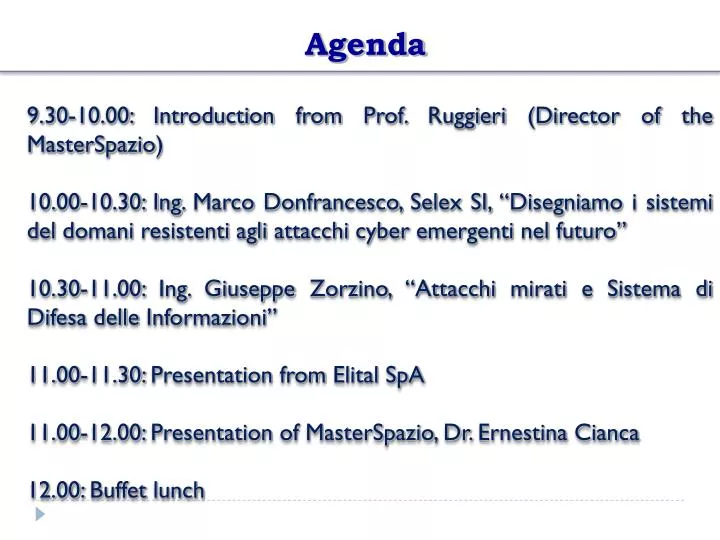
Agenda. 9.30-10.00: Introduction from Prof. Ruggieri ( Director of the MasterSpazio ) 10.00-10.30: Ing. Marco Donfrancesco , Selex SI, “Disegniamo i sistemi del domani resistenti agli attacchi cyber emergenti nel futuro”

E N D
Agenda 9.30-10.00: Introductionfrom Prof. Ruggieri (Directorof the MasterSpazio) 10.00-10.30: Ing. Marco Donfrancesco, Selex SI, “Disegniamo i sistemi del domani resistenti agli attacchi cyber emergenti nel futuro” 10.30-11.00: Ing. Giuseppe Zorzino, “Attacchi mirati e Sistema di Difesa delle Informazioni” 11.00-11.30: PresentationfromElital SpA 11.00-12.00: PresentationofMasterSpazio, Dr. Ernestina Cianca 12.00: Buffet lunch
Opening Presentation Master in Advanced Satellite Communication and NavigationSystems Director: Prof. Marina Ruggieri Coordinator: Dr. Ernestina Cianca Casa dell’Aviatore,Roma December 10, 2012
The Master of Science • The M.Sc. in AdvancedCommunication and Navigation Satellite Systems is: • Master Degree (II Level) • according to the Decreto Rettorale n° 2545 del 11.8.2003. • The title is released according to: • D.M. 509/99 (Autonomy of University and Change on the University Study) • D.M. 270/04 (successive modification)
WhySpace? • Italy has alwayy played an important international role in the space sector • Medium-long terms project less influenced by the economical cycles • Space research in Horizon 2020, Recommendations of the FP7 Space Advisory Group (SAG), June 2011: • “The conclusions of the Space Advisory Group's deliberations..... is that Space must be a major and well-funded theme of the Horizon 2020, commensurate with the strategic importance of this major industry sector, scientific discipline and human endeavour”
WhySpace? Earth Observation Navigation Entertainment Earthquake prediction? Homeland security Telecommunications Disaster Management Telemedicine Surveillance Fleet management AIS
Organization NEWS • Seminars on Cybersecurity • 15 hours dedicated to Earth-Observation • More focus on Integration of NAV-COM-Earth Observation and on interdisciplinary in ICT • More focus on the Ground-Segment
Organization Project work 10 CFU Face-to-facelecturers 35 CFU + 10 optional CFU Visittolabs Stage 15 CFU Case studies seminars 60 CFU CFU: Crediti Formativi Universitari
Organization 1500 hours 60 CREDITs 7 TeachingModules (35 CFU) 1 Project work (10 CFU) Stage (15 CFU):375 hoursof Stage • - 350 hoursof face to face Lecturers/Labs • 525 hoursofindividual work - 40hoursof face to face Lecturers/Labs - 210 hoursofindividual work
Organization: teachingmodules Fundamentals ofSpaceSystems Project and SpaceSystems Management ElectronicsofSpaceSystems Principlesof Satellite Navigation Principlesof Satellite Communications Advanced Satellite NavigationSystems Advanced Satellite CommunicationSystems LabView National Academy ElementsofSignalTheory and Processing
Organization: labs-orientedactivities 5 CFU course ability to use the SW LabView for developing HW modules
Organization: labs-orientedactivities Laboratories exercises in the HASCON Labs at Tor Vergata - SoHaPen • Satellite Compass • GPS-basedlocalization system for a fleetof mobile units • Smart Pointer (NavComfor Cultural Heritage) MySmart Pointersaysthese are the statuesof Canopo in Villa Adriana
Organization: labs-orientedactivities Laboratories exercises in the HASCON Labs at Tor Vergata • SoHaPen • Abilitazione geo-referenziata tramite interfaccia HW/SW progettata ad hoc di robot in modalità di funzionamento sciame per una data applicazione (ad esempio sminamento). • Satellite Compass • La differenza con una bussola magnetica è che tale informazione è calcola sfruttando esclusivamente il sistema satellitare GPS e non il campo magnetico terrestre. • Ambito applicativo: • Marino, su natanti per scopi di navigazione • ferroviario, su treni al fine di orientare le antenne utilizzate per la connessione ad internet
Organization: labs-orientedactivities Laboratories exercises in the HASCON Labs at Tor Vergata • GPS-basedlocalization system for a fleetof mobile units • Trasmissione di dati da unità mobili verso un centro di controllo mediante tecnologia XBee (banda 868 MHz)/ZegBee (banda 2,4 GHz) all’interno di aree di copertura organizzata in celle. • Ambito applicativo: • Corse automobilistiche • Smart Pointer (NavComfor Cultural Heritage) • Si tratta si un dispositivo in grado identificare nello spazio l’oggetto verso cui si sta puntando e rendere disponibile su terminali mobili (smartphone, tablet, ecc.) ai quali lo smartpointer è connesso mediante connessione bluethooth, i contenuti multimediali collegati allo stesso. • Ambito applicativo: • - Turistico
Teaching Staff People fromindustry Academic staff Basic courses Advanced courses
ExternalTeaching Staff Ing. Stefano Lagrasta Appointed “Navigation Technologies & Signal Processing Specialist”: staff role supporting the head of GNSS-Infomobility, Business Unit at Telespazio. Module on: Advanced Navigation Satellite Systems Ing. Elio Ligato Telespazio Module on: Project and Space Systems Management Ing. Sergio Gerosa Thales Alenia Space Italia, Supply Chain Director Module on: Project and Space Systems Management Book: Sergio Gerosa, Roberto Somma, Tecniche e metodologie di project management, La gestione di programmi complessi con particolare riferimento al settore spaziale, ARACNE EDITRICE
ExternalTeaching Staff Ing. Paolo De Vincenti Consultant, around 30 years spent at Eutelsat France, first as antenna design and then vice director of multimedia department, responsaible for developing telecommunications networks for added value services. Module on: Advanced Com. Sat. Systems Ing. Guido Vingione SERCO European Agency (SEA), GMES Space Component Data Access (GSCDA) System Project Leader. Responsible for the overall technical coordination of a large number of ESA projects including: management of sub-contractors and Integrated Teams coordination in an international environment. Module on: Advanced Com. Sat. Systems Ing. Francesco Morganti Consultant, previosuly employed at Thales Alenia Space, Sistematica. Module on: Fundamentals of Space Systems
ExternalTeaching Staff Ing. Marcello Spagnulo He is employed at the Italian Space Agency ASI, in Rome, as staff within the ASI President Office. Module on: Fundamentals of Satellite Systems Book: Marcello Spagnulo, Elementi di Management dei Programmi Spaziali, Springer Editrice Ing. Roberto Capua Sogei Spa Responsabile progetto Galileo di Sogei Module on: Advanced Navigation Satellite Systems
ExternalTeaching Staff • Special thanks to: • Business Segment Observation Systems & Radar of Thales Alenia Space • Centro Interforze per il Telerilevamento Satellitare (CITS), Pratica di Mare • Business Segment Payload TLC of Thales Alenia Space
Organization: teachingmodules MondayWednesdayFriday from 9.30 a.m. to 12.00 a. m. -> 1° TeachingUnit from to 1.00 p. m. to 3.30 p. m. -> 2° TeachingUnit from 3.30 p. m. to 4.00 p. m. -> Tutoring Assessment: Final test (written and oral) Teaching material: Handouts and slidesprovidedby the teacher All the recommendedbooks are alsoavailable in the library
Organization: project work • The project work will start after the threebasicscourses are over (end of March) • Work in teams • Manage a “small” missionforwhichtheywillhave first to: • estimate the budget, • estimate the timefor the work, • solve the problems.
Organization: stage Opportunitytoverify the acquiredknowledgebyworking on a selected project relatedtocommunication and navigation satellite systems in oneof the company/institutionthatis partner of the master. Stage/Training: from end of August 2013 to end ofJanuary, 2014 FinalExam: February 2014
PARTNERS (1/5) Welcome to our two new partners
Deadlines • Pre-enrollment via email: by21° ofDec., 2012 • Test togetoneof the fundedgrants: Within 10° ofDec. 2012 • Oralteststobeadmittedto the Master : before15 January 2013 • Listofadmittedstudentsforscholarshipspubblished on the website and in the Universitynoticeboardby18 January 2013 • Enrollment: up to25 January 2013 • FrontalLecturerswill start: 28 January 2013
AFCEA Student Project Internet of Things: Enabling Technologies and Smart Devices to improve Quality of Life • The Internet of things concept is based on the interaction of different independent systems through the Internet and can be considered as a “System of Systems Interconnected Through Internet”. • The project work concerns the realization of a smart integrated system including a smartphone and new secure low-power wireless standards (as DASH7, 6LoPAN, Bluetooth Low Energy) to support innovative and advanced applications in the fields of healthcare, fitness and homeland security. • to develop a smart integrated system for healthcare applications (including e.g. a pulse oximeter, glucose and blood pressure monitoring, etc.) • to develop a smart integrated system for homeland security applications
Organization: project work • Examplesof project works: • Integrationofsensorsformedical/safetyapplications and a gateway thatsends data to a control center for data processing. The integrationforesees the useofprotocolsfor Low PowerWSNs and the implementationof a HW/SW interfance at low powerconsumption and hence, based on newstandardssuchas DASH7, 6LOWPAN, Bluetooth Low Energy.Position estimation o train via GNSS. Eachvagonhasitsunitboardthatestimates the position with high accuracythankstocorrections sent byrefernecesstationsdesignedforthatpurposewhihcdoesnothaveitsownaugmentation network (suchas in Australia) Data willbe sent via a TETRA link.