Download
1 / 22
220 likes | 365 Views
New Orleans Hurricane Storm Damage Risk Reduction System Tour March 23-24, 2012. Host: Falcolm E. Hull, Vice President/Technical Expert, ARCADIS, U.S. Inc. Attending: Cherie Coffman, Coastal Projection Project, TAMUG Bill Merrell, George P. Mitchell Chair, Marine Sciences, TAMUG

E N D
New Orleans Hurricane Storm Damage Risk Reduction System TourMarch 23-24, 2012 Host: Falcolm E. Hull, Vice President/Technical Expert, ARCADIS, U.S. Inc. Attending: Cherie Coffman, Coastal Projection Project, TAMUG Bill Merrell, George P. Mitchell Chair, Marine Sciences, TAMUG Jerry & Winkie Mohn, West Galveston Island Properties Owners Association Dan Seal, Executive Director, Bay Area Houston Economic Partnership Helen Young, Deputy Commissioner, Texas General Land Office
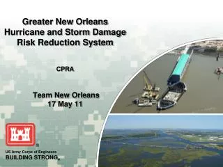
On Friday morning, March 23, we began the day with an overview presentation of the Hurricane Storm Damage Risk Reduction System and Inner Harbor Navigation Canal (IHNC) Lake Borgne Barrier.
We toured the IHNC Floodwall, Sector Gate, Barge Gate and Bayou Bienvenue Vertical Lift Gate. The IHNC-Lake Borgne Surge Barrier is the largest design build civil works project in the history of the Corps. It consists of a bypass barge gate and a flood control sector gate (each 150 feet wide) at the GIWW, a 56 foot wide vertical lift gate at Bayou Bienvenue, floodwalls that tie into the New Orleans East risk reduction system on the north end and the St. Bernard risk reduction system on the south end, and a concrete barrier wall across the Mississippi River Gulf Outlet and the Golden Triangle March. The entire structure is built to an elevation of 25 and 26 feet above sea level.
The IHNC Barrier – large pilings driven to 150ft, support pilings to 300ft – It’s 2 miles long with 3 gates – lift gate and attaching arm for barge gate shown
A tour of the West Closure Complex concluded Friday’s “day in the field”. The Gulf Intracoastal Waterway -West Closure Complex, located approximately one half mile south of the confluence of the Harvey and Algiers canals on the Gulf Intracoastal Waterway, is a risk reduction feature that reduces risk to residences and businesses in three parishes on the west bank of the Mississippi River: Orleans, Jefferson, and Plaquemines. The structural features being built by the Corps will reduce the risk associated with a storm surge event that has a one percent chance of occurring in any given year, or a 100-year storm surge. The total construction value for the West Closure Complex is an estimated $1 billion. Largest pumping station in the world,
Up early Saturday to see Seabrook Floodgate Complex Lake Ponchartrain Seabrook Bridge Inner Harbor Navigation Channel
The purpose of this navigable floodgate is to provide a barrier in the IHNC near the shore of Lake Pontchartrain that can be closed during storm events to keep surges from entering the IHNC and potentially overtopping the existing levees and floodwalls along the canal.
On Saturday, we also visited the St. Bernard Polder and the LPV-149 Sector Gate and Appurtenances.The risk reduction system in St. Bernard Parish, often referred to as the Chalmette Loop or St. Bernard System, consists of approximately 23 miles of floodwall, from Bayou Bienvenue's intersection with the MR-GO in the northeast to the Caernarvon Canal's confluence with the Mississippi River near the Plaquemines Parish line. In addition, work consists of constructing sector gates at Bayou Dupre and Caernarvon and a vehicular floodgate at Highway 46 in Verret.These floodwalls and gates will reduce risk to residents and businesses of St. Bernard Parish from a storm that has a 1 percent chance of occurring in any given year.
Actually seeing the structures completed and ready to protect New Orleans drove us to believe that Galveston and the 5 other counties along the upper Texas Gulf coast can be protected against storm surge and that it could be completed in a few years.
Deltaworks, Ike Dike, New Orleans • All shorten the perimeter as much as possible • All keep the surge out of internal waters • All use gates to accomplish this
A coastal spine with gates shortens the protection needed in Texas Houston Ship Channel High Island Bolivar Peninsula Bolivar Roads Existing Seawall Galveston Island Intracoastal Waterway •San Luis Pass
Greater New Orleans is now protected by a 133 mile parameter of levees, flood walls and gated barriers. The total cost of Greater New Orleans Hurricane and Storm Risk Reduction System so far is 14.5 billion dollars. The strategy is to keep massive surges from entering the system by shortening the outer protection needed by using 4 gated passages. The System was started in 2008 and achieved 100-yr surge event protection in June 2011.
USA Surge Protection Systems Greater New Orleans Ike Dike - Galveston Bay • 75 mile coastal spine 17ft high with 10,000yr protection • 2 gated barriers – largest passage 530ft • 2-mile water barrier with many gates – Bolivar • Pumping not needed • Depends - beach or highway use • Significantly fewer or none • Significantly fewer or none • 133 mile parameter up to 31.5ft high with 100yr protection • 4 gated barriers – largest passage 225ft • 2-mile water barrier with 3 gates – Inner Harbor Navigation Ch • Pumping Stations - 4 federal (world’s largest) and 73 local • Land acquisition • Wetlands issues • River and canal issues
Background – Other Studies • LA and MS hit by Katrina • Upper TX hit by Rita and Ike • LA – Greater NOLA has completed studies and SPENT $14.5B on Surge Protection • MS - Awarded $10M without local match for Comprehensive Coastal Study (3 counties)
Status USACE 6-County Study • Upper TX coast much more strategically important to US • Yet, to date, Upper TX Coast Study has received minimal funding ($75K for expanded scoping) with about $200K now available toward the actual study • Unlike MS, 50% local match required for the study and strict cost/benefit requirements
What’s Needed USACE Study • For the USACE to do an adequate study of the Sabine and Galveston Bay Complexes, considerably more $ as well as study flexibility is needed
Next Steps • Obtain MS study legislation – DONE - see next slide • White Paper developed for Texas delegation including what a reasonable Texas request should be • Find Heroes to propose legislation – House and Senate • Develop local/state leadership • Form citizen’s group • Rally local support • Visit DC
Department of Defense Appropriations Act, 2006 (P.L. 109-148) 30 December 2005, which states: “For an additional amount for “investigations” to expedite studies of flood and storm damage reduction related to the consequences of hurricanes in the Gulf of Mexico and Atlantic Ocean in 2005, $37,300,000 to remain available until expended: Provided, that using$10,000,000 of the funds provided, the Secretary shall conduct an analysis and design for comprehensive improvements or modifications to existing improvements in the coastal area of Mississippi in the interest of hurricane and storm damage reduction, prevention of saltwater intrusion, preservation of fish and wildlife, prevention of erosion, and other related water resource purposes atfull Federal expense; Provided further, that the Secretary shall recommend a cost-effective project,but shall not perform an incremental benefit-cost analysis to identify the recommended project, and shall not make project recommendations based upon maximizing net national economic development benefits; Provided further, that interim recommendations for near term improvements shall be provided within 6 months of enactment of this act with final recommendations within 24 months of this enactment.”
Levee System Ship Channel Gate
SSPEED Concept – Galveston County • Increases surge in non-diked areas – east of Hwy 146, Bolivar, west Galveston island, mainland west of Texas City dike • May cause Texas City Dike to be topped • Local match for Galveston City ring dike difficult • General access to and fresh water flows into Galveston Bay from upper county compromised • Coastal Recreation Area – tax base issues