SAROPS EDS Environmental Data Server
SAROPS EDS Environmental Data Server. . Art Allen United States Coast Guard – Office of Search & Rescue. Eoin (Owen) Howlett ASA. USCG Area of SAR Responsibility. CG wide SAR Statistics. Search & Rescue Problem. Create a SAR case when alerted. Search & Rescue Problem.

SAROPS EDS Environmental Data Server
E N D
Presentation Transcript
SAROPSEDS Environmental Data Server . Art Allen United States Coast Guard – Office of Search & Rescue Eoin (Owen) Howlett ASA
Search & Rescue Problem • Create a SAR case when alerted
Search & Rescue Problem • Create a SAR case when alerted • Gather information about case
Search & Rescue Problem • Create a SAR case when alerted • Gather information about case • Get environmental data & uncertainties
Search & Rescue Problem • Create a SAR case when alerted • Gather information about case • Get environmental data & uncertainties • Use model to determine search area
Search & Rescue Problem • Create a SAR case when alerted • Gather information about case • Get environmental data & uncertainties • Use model to determine search area • Estimate resource availability and capability
Search & Rescue Problem • Create a SAR case when alerted • Gather information about case • Get environmental data & uncertainties • Use model to determine search area • Estimate resource availability and capability • Plan, promulgate & perform the next search
Search & Rescue Problem • Create a SAR case when alerted • Gather information about case • Get environmental data & uncertainties • Use model to determine search area • Estimate resource availability and capability • Plan, promulgate & perform the next search • Evaluate the completed search
Search & Rescue Problem • Create a SAR case when alerted • Gather information about case • Get environmental data & uncertainties • Use model to determine search area • Estimate resource availability and capability • Plan, promulgate & perform the next search • Evaluate the completed search • Repeat above until survivors are found and rescued
USCG Data Parameters Currents - Sea Surface
USCG Data Parameters Surface Wind Speed (10m)
Environmental Data Server (EDS) • Access to global/regional current and wind data • Data from NOAA, NAVY, Regional Associations, Universities and commercial providers • Aggregation Services (temporal and spatial) • Redundancy and Backup • Objective Analysis Tools • Web Services Protocols
SAROPS EDS Data • Operational Forecast Model Data • Observation Data (NDBC buoys, satellite, drifters, Sea Surface Radar, etc.) • Seasonal data • Tidal databases (harmonic databases)
EDS Services SLDMB’s Surface Radar Global Product Coastal Product Aggregated Product Regional Product
EDS Services SLDMB’s Surface Radar NAVY Global NCOM Served via EDS Data Service Global Product Coastal Product Aggregated Product Regional Product
EDS Services SLDMB’s Surface Radar Tidal AdCIRC served via EDS Data Service Global Product Coastal Product Aggregated Product Regional Product
EDS Services SLDMB’s Surface Radar Global NCOM and ADCIRC via EDS Aggregation Service Global Product Coastal Product Aggregated Product Regional Product
EDS Services SLDMB’s Surface Radar Great Lakes Regional Model Global Product Coastal Product Aggregated Product Regional Product
EDS Services SLDMB’s Aggregation of short and long range CODAR Surface Radar Global Product Coastal Product Aggregated Product Regional Product
EDS Services Objective Analysis on Drifting Buoy Data SLDMB’s Surface Radar Global Product Coastal Product Aggregated Product Regional Product
Example EDS Data Sources • Winds • FNMOC NOGAPS • FNMOC COAMPS • NOAA NCEP NAM • NOAA NCEP GFS • NOAA NDFD* • NOAA NDBC • Regional Models (e.g GLERL) Other… commercial • Currents • NAVO Global NCOM • NOAA NCEP HYCOM • NOS Regional • ADCIRC • CODAR • Regional Models Other… Bluelink, Satellite Data (AOML), commercial
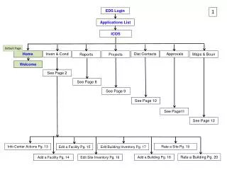
Catalog Server Winds Currents Drifters Weather THREDDS OPeNDAP EDS Catalog DB
Catalog Server Winds Currents Drifters Weather THREDDS OPeNDAP EDS Catalog DB Internet SAROPS Client Web Client
Catalog Server Winds Currents Drifters Weather THREDDS OPeNDAP EDS Catalog DB Web Services Web Service XML Request Internet SAROPS Client Web Client
Catalog Server Winds Currents Drifters Weather • Data Service • Spatial Aggregation Service • Temporal Aggregation Service • Objective Analysis THREDDS OPeNDAP EDS Catalog DB Web Services NetCDF Data Internet SAROPS Client Web Client
Catalog Server Winds Currents Drifters Weather THREDDS OPeNDAP EDS Catalog DB Web Services OGC WMS/WFS/SOS/WCS Internet SAROPS Client Web Client
Catalog Server Winds Currents Drifters Weather THREDDS OPeNDAP EDS Catalog DB Web Services JMBL Internet SAROPS Client Web Client
Temp NWS NDBC CO-OPS E. GOM HABS BULLETIN Color Currents Winds D A T A C O N T E N T S T D Salinity O G C W F S - W C S - W M S Currents PACOOS IEA NOS CO-OPS All 7 Level Color NHC SLOSH CI MODEL Winds Waves Level NESDIS Coastwatch Winds HIF PROGRAM Temp Winds Waves Waves GML/CSML & NetCDF Decision Status Months 0-12 Month 18 Month 24 Month 36 Test & Evaluation Benchmarked Integration Transport • Metrics • Efficiency • Speed • Resolution • Accuracy • Length • Economics scheduled Feb 2008 Aug 2008 Feb 2009 Feb 2010 actual May 2008 Aug 2008 Feb 2009 Feb 2010
Davis/ CODE drifterSelf-Locating DatumMarker Buoys (SLDMB) 30 minute GPS positions via Argos
Conclusions • SAROPS - operational in the USCG since January 2007 • Use of open standards allows for interoperability • Adding improved regional coastal data • Need for uncertainty measurements and dispersion coeff’s • Researching new Lagrangian techniques
Questions Art Allen Arthur.A.Allen@uscg.mil Eoin Howlett ehowlett@asascience.com