
Understanding Plate Tectonics: The Dynamic Nature of Earth's Crust
This overview of plate tectonics explores the lithosphere, consisting of the Earth's crust and the rigid upper mantle, and the astenosphere's role in plate movements. It distinguishes between oceanic and continental crust, their properties, and historical geological theories, including Wegener's continental drift and Pangaea. The mechanisms behind plate movements, including thermal convection and sea-floor spreading, are examined alongside the types of plate boundaries—constructive, destructive, and passive. Discover how these processes shape our planet's landscape through mountains, earthquakes, and volcanic activity.

Understanding Plate Tectonics: The Dynamic Nature of Earth's Crust
E N D
Presentation Transcript
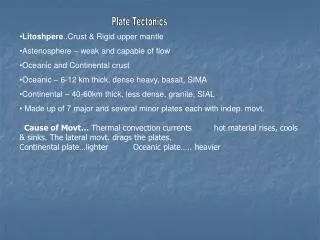
Plate Tectonics • Litoshpere..Crust & Rigid upper mantle • Astenosphere – weak and capable of flow • Oceanic and Continental crust • Oceanic – 6-12 km thick, dense heavy, basalt, SIMA • Continental – 40-60km thick, less dense, granite, SIAL • Made up of 7 major and several minor plates each with indep. movt. • Cause of Movt… Thermal convection currents hot material rises, cools & sinks. The lateral movt. drags the plates. • Continental plate…lighter Oceanic plate….. heavier
Continental Drift.. • Wegener 1912.. • Pangaea.. One super continent. 225 million yrs ago • 200m yrs ago split…. • Laurasia.. Europe, Nth America & Asia. • Gondwanaland.. Sth. Am, Africa, India, Australia, Antartica. • 1963 (Harry Hess) Theory accepted… discovered Mid Atlantic Ridge which was proof of ocean floor spreading. • Proof: Continental Fit .. Like a jigsaw, • Matching fossils; • matching rocks (structure & type) • Mt. ranges…Appalachion Mts of U.S. & Caledonian of Irl & Br. • both fold mts. • Matching glacial deposits in S. America, Africa and Australia • Sea floor spreading and Age of ocean floor: oil drilling shows edge of ocean rock 200m yrs older than the Mid Atlantic ridge. • Satellite measurements show Sth Am. & Africa moving 2.5cm apart each year.
Plate Boundaries: Constructive • Diverge.. Move apart causes cracks fills with magma. • Result: (i) New ocean floor… • (ii) Mt. range/ridge e.g. Mid Atlantic Ridge … cont. move apart. • (iii) Islands form…. e.g. Iceland. • East African Rift Valley • 6000km long • 2 new African plates – Nubian Plates & Somali Plates • Red Sea is a part of the Rift Valley • Western and eastern Rift Valley • Contains some of the deepest lakes in the world • Lake Tanganyika – 1,470 metres deep • Lake Victoria – 2nd largest lake in the world
Africa Eastern Africa- divergent plates Eurasian & African plates collided 25m yrs ago -- fractures. Magma plumes warped the surface upwards, making it brittle. It fractured and moved apart. This gave rise to 3 active rift zones Gulf of Eden East African Rift Red Sea The Arabian Peninsula split off from Africa & opened up the Red sea and the Gulf of Eden. East Africa in 50m yrs will detach itself and form a new continent & sea.
Destructive • B) Converge.. Meet one plate sinks = subduction zone…. Crust destroyed. • Oceanic & Oceanic … older heavier plate descends under lighter plate • (i) Narrow trench e.g Mariana Trench where Pacific & Phillipinnesplates meet. • (ii) Volcano … Crust melts & produces magma. • (iii) Island arcs…hotspots as magma melts the crust…plates move eg. Japan. • (iv) Earthquakes… caused by collision stress
2.Oceanic & Continental… collide oceanic sinks Result trench, volcano, earthquake, E.g. Andes Mts. (Sth. Am.) • Continental & Continental….. Collide buckle & fracture. • Result Mts. & earthquakes e.g. Himalayan mts. Where Indian and Eurasian plates met…. Contain sea fossils… proof that they were once in the sea. Passive Plates slide past each other (sheer) -- (i) transform fault… San Andreas Fault… Pacific & American plates. (ii) Earthquakes
Constructive • Rising current of magma splits continent • Move apart – water rushes in – ocean • Mid-ocean ridge above plume of magma • Volcanoes along ridge • Some islands e.g. Iceland might appear
Destructive • Ocean-ocean – subducted plate melts and rising magma creates line of volcanoes called island arc • Ocean-continent – heavier ocean plate sinks, buckles and folds, islands, extinxt volcanoes pushed against continent edge making it wider • Sinking magma creates volcanoes
Continent- continent- Large Fold Mts • Passive- Mostly along mid ocean ridges • Sometimes on dry land – San Andreas fault • Earthquakes
Ireland on the move Irelands past shows evidence of desert & tropical climates. Geology: Croagh Patrick, Mayo Quartzite… Sugarloaf, Wicklow formed at opposite ends of an ocean. Limestone…. Central plain - formed at bed of tropical ocean. Fold Mts. Nth west they run sw/ne Munster they run e/w Why? Different rock types. Plates have drifted from 30˚ south of equator to 54˚ north ... Drifted 9,000 miles in 500 million years.
Million Years ago • 400 Nth & sth Irl join(20˚ sth) …. Causing folding and faulting. • 380 Move Nth… desert area… only nth. section above sea level • Erosion & deposition in sth. - old red sandstone, Munster • Rise in sea level- Irl. submerged in tropical seas. • Result in limestone of the Burren. • European & African plates collide - Fold mts. Of Munster. • Erosion & marine sediments form into oil & gas. • 100 Uplift… land rises above sea level-- more limestone & chalk • 65 Volcanic bursts & rifting-- detach from America & form Atlantic ocean & Antrim Plateau.


