Chapter 5: Other Major Current Systems
Chapter 5: Other Major Current Systems. Key Points: Summary of Chapter 5. Components of the equatorial current system include: westward flowing N,S equatorial currents (driven by trades and geostrophy) eastward flowing counter current (surface/subsurface), and undercurrent
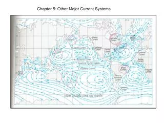

Chapter 5: Other Major Current Systems
E N D
Presentation Transcript
Key Points: Summary of Chapter 5 • Components of the equatorial current system include: • westward flowing N,S equatorial currents (driven by trades and geostrophy) • eastward flowing counter current (surface/subsurface), and undercurrent • Equatorial Current System best defined in the Pacific (basin size, ITCZ) • ITCZ is north of the equator, as SE Trades cross hemispheres create divergence just south of the equator and convergence around 4o N • Prevailing easterly winds slope the sea surface up to the western end of the basin, creates an eastward directed pressure gradient, counter currents flow eastward in regions of low wind stress (doldrums) • This pressure gradient force also drives the Equatorial Undercurrent (wind stress at the surface around the equator is strong but at depth, baroclinic conditions are sufficiently strong to drive the fast flowing current to the east) Coriolis constrains the flow to the equator (meanders can exist)
Key Points Continued: Summary of Chapter 5 In the Pacific and Atlantic surface divergence south of the equator associated with the South Equatorial Current (SEC) produces regions of upwelling. Upwelling is also produced by Trade Winds blowing along the eastern side of the basins. This can be seasonal in regions where the ITCZ migrates The Asian Monsoons influence the circulation of the Indian Ocean. The Equatorial Undercurrent is seasonal, and the surface Somali Current reverses direction becoming an intense western boundary current during the Southwest Monsoon. The North Equatorial Current also reverses direction and become the South-West Monsoon Current Disturbances in the ocean (such as Monsoons, ENSO, etc..) in part, propagate as Kelvin and Rossby waves both at the surface (barotropic waves) and along density boundaries (baroclinic waves) Kelvin waves travel eastward along the equator or along the coast (NH coast on right side, SH coast on left side) Rossby waves (Planetary waves, conservation of potential vorticity) travel westward along lines of latitude (slower)
Keep In Mind: Coriolis Force on the Equator is zero Coriolis Force by 0.5o influences flow of water Currents To Know: North Equatorial Current (NEC) South Equatorial Current (SEC) Equatorial Counter Current (ECC) Equatorial Under Current (EUC)
Migration of the ITCZ • NE and SE Trade Winds cross the equator • Seasonal • Variations in the magnitude and presence of equatorial currents, in each basin • Equatorial current system best defined in the Pacific Ocean (trade winds blow over longer distances, less migration of the ITCZ)
Refined Picture of the Equatorial Current System: Improved Measuring Techniques Variability in magnitude NEC, SEC are driven by wind and geostrophy NECC, pressure gradient, Coriolis adds to the convergence at 4o N associated with the SEC NECC, SECC flow in regions of weak winds ‘doldrums’ Subtropical counter-currents -------- horse latitudes?
Equatorial Undercurrent (EUC) & Eastward Directed Pressure Gradient Wind driven water from the surface mixed layer piled on the western side of the basin Wind stress balances the pressure gradient (Coriolis Force ~= 0 at equator) Adjustment (depression) of the thermocline on the western end Baroclinic conditions at depth drive a jet-like current eastward eventually balance by friction (eddy viscosity)
Equatorial Undercurrent (EUC) & Eastward Directed Pressure Gradient Core of EUC around 200m water depth Velocity can approach 1.5 m/s
ECC EUC North Subsurface Counter Current westward
Think About Recirculation in the Equatorial Current System Cromwell current (EUC) water originates primarily from the SEC Once reaching the eastern basin EUC water feeds the NEC and the SEC
‘doming’ isotherms Thermocline: 17o C Thermostads - pycnostads Remember: sea surface slope – pressure gradient in the surface mixed layer is opposite the slope of the thermocline
Upwelling In Low Latitudes: Eastern Tropical Atlantic Seasonal variation, migration of ITCZ, strength of SE Trades More permanent upwelling regions associated with westward directed wind stress
Monsoonal Circulation: winds that change seasonally • Northeast Monsoon in winter • surface circulation of the northern Indian Ocean most closely resembles that of the Atlantic and Pacific • Southwest Monsoon in summer • stronger of the two
Indian Ocean Surface Circulation Somali Current 180o reversal becomes an intense western boundary current during southwest monsoon.
Chlorophyll concentrations (orange/yellow): illustrating the effects of upwelling associated with the southwest monsoon Low level jet drives water away from the coast producing regions of more intense upwelling as well as the fast flowing Somali Current. Note the Somali Current is an intense western boundary current but is not derived from the same balance of forces as the Gulf Stream.
Agulhas Current: is the next most powerful western boundary current, second only to the Gulf Stream. Its retroflection off the tip of southern Africa is a source of eddies, many of which are carried into the Atlantic. Think about: basin land boundaries, strength of coriolis etc.
Waves: the ocean can respond to the winds in distant places by means of large-scale disturbances that travel as waves. Barotropic: surface waves Baroclinic: density surface (thermocline) Rossby (Planetary Waves) Kelvin
Examples of barotropic and baroclinic waves propagating through the ocean Most tides are barotropic ‘Kelvin’ waves Think about what would happen if the wind stress was dramatically reduced or changed directions in the case of the Asian Monsoon
Kelvin Waves Travel eastward along the equator as a double wave ‘equatorial wave guide’ Travel along coasts (coast on right in the NH and on the left in the SH) Balance between pressure gradient force and coriolis force.
Kelvin Waves • Surface equatorial kelvin waves travel ~200 m/s • Rossby radius of deformationL = c/f • High latitudes smaller eddies closely trapped to the coast (increase in planetary vorticity) • Low latitudes larger radius
Kelvin waves in the thermocline can have dramatic effects, particularly in low latitudes where the mixed surface layer is thin. Northward migration of ITCZ in western Atlantic generates disturbance that propagates eastward Splits into two coastal Kelvin waves when hits the eastern boundary The region of the disturbance where the thermocline bulges upward cold nutrient rich sub-thermocline water can reach the surface 4-6 week travel time
Rossby Waves: Propagate from east to west across basin Travel along lines of latitude Move slower than Kelvin waves Conservation of Potential Vorticity Example: Waves in the jet-stream
Modeled Propagation of Equatorial Kelvin Wave At mid latitudes - western sides of ocean basins are more connected to mid ocean disturbances because Rossby Waves can communicate the information At the equator the ocean can respond quicker to disturbances because both Kelvin and Rossby waves can propagate
ENSO: El Nino – Southern Oscillation “Interest in the phenomenon of El Nino goes back to the mid-19th century but it was the El Nino event of 1972-73 that stimulated large-scale research into climatic fluctuations, which began to be seen as a result of the interaction between atmosphere and ocean.”
El Nino events are perturbations of the ocean-atmosphere system Disturbance – a depression in the thermocline accompanied by a slight rise in sea-level propagates eastwards along the Equator as a pulse or series of pulses (Kelvin Waves)
SO Index and Multivariate ENSO Index Atmospheric pressure at sea level, zonal and meridional winds, sea-surface temperature, surface air temperature, and the overall cloudiness
Satellite altimetry data for the 1997-98 ENSO event At the eastern boundary, the equatorial Kelvin waves split into northward – and – southward traveling coastal Kelvin waves Some energy is reflected back as a Rossby wave/s
Circulation At High Latitudes The Arctic Sea: Relatively enclosed basin (connection to the Pacific through the Bering Strait and to the Atlantic through the Greenland and Norwegian Seas) Enclosed nature influences ice cover Circulation: was originally deduced from ice flows and drifting ships, supplemented with direct current measurements and geostrophic calculations
Seasonal change in ice cover for northern and southern high latitudes ~10% of Arctic ice leaves annually through the Fram Straits between Greenland and Spitsbergen
The Great Salinity Anomaly 1973 – 1981 “The Day After Tomorrow” omg Low salinity plume of water circulates on the surface and disrupts deepwater formation
Antarctic Circumpolar Wave (from Wikipedia) The Antarctic Circumpolar Wave is a coupled ocean/atmospherewave that circles the Southern Ocean in approximately eight years. Since it is a wave-2 phenomenon (there are two ridges and two troughs in a latitude circle) at each fixed point in space a signal with a period of four years is seen. The wave moves eastward with the prevailing currents. Note that although the "wave" is seen in temperature, atmospheric pressure, sea ice and ocean height, the variations are hard to see in the raw data and need to be filtered to become apparent. Because the reliable record for the Southern Ocean is short (since the early 1980s) and signal processing is needed to reveal its existence, some climatologists doubt the existence of the wave. Others accept its existence but say that it varies in strength over decades. The wave was discovered simultaneously by Warren White and R G Peterson; and Jacobs and Mitchell; in 1996. Since then, ideas about the wave structure and maintenance mechanisms have changed and grown: by some accounts it is now to be considered as part of a global ENSO wave.
References: White, W.B. and R.G. Peterson (1996): An Antarctic circumpolar wave in surface pressure, temperature and sea-ice extent. Nature380:699–702. Jacobs, G. A., and J. L. Mitchell (1996): Ocean circulation variations associated with the Antarctic Circumpolar Wave. Geophysical Research Letters23(21):2947–50