Download
1 / 5
50 likes | 195 Views
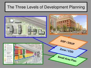
The Three Levels of Development Planning . DSP / DSUP . Zone / CDD. Small Area Plan.

E N D
The Three Levels of Development Planning DSP / DSUP Zone / CDD Small Area Plan
The Consolidated Master Plan is comprised of fifteen Small Area Plans (SAPs) that describe the vision for every neighborhood in the City. It also includes chapters on topics of citywide relevance, such as Transportation, Open Space, Historic Preservation, and Urban Design. The Consolidated Master Plan was adopted by the City Council on June 24, 1992. Thirteen of the fifteen SAPs have been amended and/or updated in the past decade. The Alexandria West SAP in which the vast majority of the Beauregard Corridor Planning Area is located is one of the two oldest SAPs still in effect, having last been amended in 1999. These fifteen SAPs describe the aspirations for land use, commercial and retail services, transportation, residential income mix, building scale, road net, open space, mixed-use development, etc., for every neighborhood in the City. As such, SAPs serve as a guide for zoning. Small Area Plans
ZONES: Every parcel of land comprising the City of Alexandria is located in either a (1) Residential; (2) Commercial, Office and Industrial; (3) Mixed Use; or (4) Special Use Zone. Detailed descriptions of what uses and structures can and cannot be located in the numerous sub-categories of each of these zones are contained in the Zoning Ordinance that was enacted by City Council “to promote the health, safety and welfare of the residents of the City of Alexandria and to implement the Consolidated Master Plan of the city.” CDDs: The Coordinated Development District (CDD) is a type of Mixed Use Zone that is used in areas of of the City that are of such size or situation “as to have significant development related impacts on the city as a whole or major portions thereof and in order to promote development consistent with the Master Plan. A site zoned CDD is intended for a mixture of uses to include office, residential, retail, hotel and other uses with appropriate open space and recreational amenities to serve the project users and residents of the city. A CDD zone is intended to encourage land assemblage and/or cooperation and joint planning where there are multiple owners in the CDD zoned area.” There are currently 18 CDDs in the City. Virtually all of the land in the BCPA west of I-395 is in CDD #4 (Winkler Tract). Zones & CDDs
DEVELOPMENT SITE PLAN (DSP): A DSP is required in all zones for any development that contains three or more dwelling units, a building or addition that is 3.000 sq. ft. or larger, parking lots with five or more parking spaces, a building addition that is 1/3 or more of the existing gross square footage of the building, or development that meets other criteria listed in Section 11-400 of the Zoning Ordinance. DSPs contain specific information about building location and elevations, landscaping, lighting, open space, and other site amenities. DSPs are approved or denied by the Planning Commission. DSPs do not require review by the City Council. DEVELOPMENT SPECIAL USE PERMIT (DSUP): A DSUP is required in all zones for any development that requires a site plan and specifically requires a DSUP for the type of land use requested; and for development that is requesting a parking reduction; a modification to the yard, landscape, or open space requirements; increased building height; increased Floor Area Ration (FAR); or meet other special criteria listed under the applicable zone in the Zoning Ordinance. DSUPs contain information similar to that found in DSPs, but in greater detail. The Planning Commission considers requests for DSUPs at public hearings and forwards a recommendation for approval or denial to the City Council. The City Council then considerd that recommendation and either approves or denies DSUPs. DSPs & DSUPs
The final “layer” of the development process is comprised of five Phases. Phases 1, 2, and 3 involve the conceptual, preliminary and final reviews of the DSP/DSUP. These three Phases involve extensive interaction with the community and can take from 12 to 18 months to complete. Phases 4 and 5 involve City Departments and can take anywhere from several months to many years to complete. From DSP/DSUP to Completion