Download
1 / 16
160 likes | 298 Views
An alternative analysis of the probabilistic seismic hazard for Las Vegas Valley, Nevada. B arbara L uke W anda j. T aylor. Active Faults in and near Las Vegas Valley. sources of M>6 earthquakes since 1.6 Ma distant sources Sources within Las Vegas Valley

E N D
An alternative analysis of the probabilistic seismic hazard for Las Vegas Valley, Nevada Barbara Luke Wanda j. Taylor
Active Faults in and near Las Vegas Valley sources of M>6 earthquakes since 1.6 Ma distant sources Sources within Las Vegas Valley • Las Vegas Valley fault system and Frenchman Mtn fault 100 km radius
Las Vegas Valley fault system • EF splay - MRE 2245 BCE • VVF splay – MRE14,500 14C BP (dePolo et al., 2006)
Las Vegas Valley well data 1400+ well logs Sediment ranges from fine to coarse Alluvial fans around basin Interfingered grain sizes near LVVFS
Las Vegas valley basin fill at depth • Well data show that ~2/3 of the basin-fill is > ~5 Ma • <5 Ma basin has less paleorelief along its base, is broader and more symmetric • Shape difference and depocenter shift caused by E-dipping LVFS < ~5 Ma >~5 Ma bedrock
Superimposed basins Non-planar faults Upper basin controlled by LVVFS and FMF
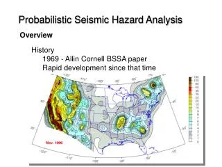
Our seismic hazard according to uSgs (2008) Hypothetical bedrock outcrop * 0.2-s spectral acceleration 2% PE in 50 years ~ 2500 year return period • Probabilistic seismic hazard analysis (PSHA): Combined hazard due to multiple earthquake sources • 3 ground shaking parameters • Peak Ground Acceleration (PGA) • 0.2-s spectral acceleration • 1.0-s spectral acceleration • 10%, 5%, 2%probability of exceedance (PE) in 50 years • Uses logic tree formalism • Fault parameters • Fault recurrence • Ground motion relations Acceleration, g 0.35 – 0.65 g http://earthquake.usgs.gov/hazards/products/conterminous/2008/maps/ * Does not address effects of basin-fill sediments Model does not explicitly consider most of Las Vegas Valley Fault System (LVVFS)
Usgs Fault class “B” Not considered explicitly as fault source in PSHA
new psha- SuchanLamichhane, Ph.D. Lamichhane, S., Luke, B. Taylor, W. 2014. An alternative analysis of the probabilistic seismic hazard for Las Vegas Valley, Nevada. Bulletin of the Seismological Society of America 104:741-768. • All known sources within 200 km • 29 Latest Quaternary • 1 Late Quaternary (Frenchman Mountain) • What is different from USGS (2008)? • Faults added:Cashman, Decatur, Valley View, Whitney Mesa, Rock Valley, West Specter Range, Pahrump Valley, Yucca Mountain – up toM7.2 • Faults characteristics modified: • Eglington: slip rate • Black Hills: magnitude and slip rate Added USGS 2008 Heavy outlines: strike-slip; otherwise normal
Faults 200 km Added Added WMF: Whitney Mesa Fault VVF: Valley View Fault CF: Cashman Fault DF: Decatur Fault USGS quaternary fault and fold database http://earthquake.usgs.gov/hazards/qfaults/google.php October 2011
Psha uses Logic tree Addresses uncertainties due to lack of knowledge and understanding (“epistemic”) Ground motion prediction equation Weight Different with this analysis
Psha outcome Total hazard curves • Reference location EZ-FRISK v. 7.62 10% PE in 50 years 2% PE in 50 years Uniform hazard spectra 72 % 5% damping 69 % 71 % 2% PE in 50 years: ~70% increase Period (s)
Psha outcome • 441 locations, ~ 3 km grid Deaggregations • PGA LVVFS Background & gridded sources 0.15 – 0.55 g Peak ground acceleration Distant faults Reference location Long period (4 s) 4 seconds period 2% PE in 50 years
PGA 2% PE in 50 years 5% PE in 50 years 10% PE in 50 years ~ 0.2 - 0.6 g ~ 0.1 - 0.3 g ~ 0.07 - 0.1 g • Compare to USGS 2008 • PGA is: • Consistently higher • Maximum increase ~150% • Greatest impact in north-central, least in south News: USGS next iteration maps (2014 preliminary): Hazard increases by ~ 30%
We acknowledge • SuchanLamichhane • Technical contributions from Woody Savage, Jeff Wagoner, Alex Goya • Funding from DOE, UNLV PRELIMINARY http://earthquake.usgs.gov/hazards/2014prelim/