Download
1 / 36
360 likes | 465 Views
Join us to discuss the purpose, development, and implementation of the LYNX Blue Line Extension Station Area Plans, with updates on the BLE Project and feedback opportunities. Learn about the comprehensive planning process and key milestones.

E N D
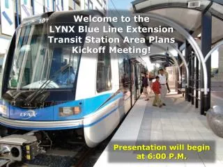
Welcome to the LYNX Blue Line Extension Transit Station Area Plans Kickoff Meeting! Presentation will begin at 6:00 P.M.
Why Are We Here? • Discuss the Purpose of Station Area Plans • Introduce the Station Area Planning Initiative • Provide an Update on the BLE Project • Describe the Plan Development Process • Describe Plan Implementation and the Northeast Corridor Infrastructure Program (NECI) • Receive Feedback on the Station Area Plan Development Concepts
Staff Team • Charlotte-Mecklenburg Planning Department • Charlotte Area Transit System (CATS) • Engineering & Property Management • Corporate Communications • Charlotte Department of Transportation (CDOT) • Mecklenburg County Park and Recreation • Neighborhood & Business Services • Charlotte-Mecklenburg Utilities (CMU) • Charlotte Fire Department • Charlotte-Mecklenburg Police Department • Solid Waste Services • Stormwater Services • Land Use and Environmental Service
Background November 2001 January 2010 August 2011 September 2011 June 2012 Existing Conditions Report Station Area Principles NoDa Vision Plan Environmental Impact Study New Starts Application
Asking Questions • Four ways to ask a question: • Submit a question form during the presentation • Ask your question during the open house portion • Line up behind microphone to ask your question • Email your question to: kcornett@charlottenc.gov • Questions and answers will be posted to • the project web page at CHARMECK.ORG • and summarized at the October 18 meeting.
Blue Line Extension (BLE) Project Update • LYNX Blue Line Extension (BLE) • 9.3 miles • Implementation in 2017 • +25,000 daily riders • Connects UNC Charlotte campuses • Major Achievements • FTA issued Record of Decision in December 2011 • FTA approved entry into Final Design in July 2012 • FTA Full Funding Grant Agreement in October/November 2012
BLE Profile • 11 Stations (7 walk-up / 4 park-and-ride) • Accommodates 3-car trains • Approximately 3,100 parking spaces • Congestion-free commute • Connecting bus services • Convenient and safe station amenities for customers • Security features • Bicycle parking • Public art • Shelters, garbage cans, benches • Trees • Lighting • Ticket vending machines (TVMs) • Maps and schedules
BLE Update *Schedule subject to change
What is a Station Area Plan? • Policy Guide that Provides a Framework for Future Growth and Development • Provides Detailed Land Use and Community Design Recommendations for each Station Area • Identifies Public and Private Investments and Strategies Needed to Realize the Plan Vision • Updates the Centers, Corridors and Wedges Boundary for the Plan Area • Provides Building Setback and Streetscape Standards for Properties with Urban Zoning Districts • Represents a Shared Vision for the Future
What is a Station Area Plan? • Elements Typical of Area Plans • Vision • Land Use/Transportation/Community Design Recommendations • Recommended Infrastructure Improvements • Implementation Section with Recommended Zoning Changes • Street Cross-sections that Identify Future Curb Lines • Identifying Setbacks from Back-of-Curb Lines
What Happens After Plan Adoption?
Plan Areas • Red lines show station area boundaries. • Criteria Used to Determine Plan Boundaries: • Properties within ½ mile of the transit station. • Includes some properties in neighborhoods zoned single family. • Uses “natural” boundaries where possible (streets, rear property lines, etc.).
Policy Context • Activity Centers • Center City • Mixed Use Center • Industrial Center • Growth Corridors • Established Neighborhood Areas • Transit Station Areas • Interchange Areas • General Corridor Areas • Wedges
What Can You Expect From a Station Area Plan? Clarify the Vision for the Area Identify and provide policies to address development opportunities and issues Identify public and private investments needed to achieve vision Possibly recommend zoning changes in appropriate locations Guide more appropriate development Create regulations or laws Provide funding and implementation means overnight Rezone property Halt development But not . . . But not . . . But not . . . But not . . .
Plan Development Process Public Workshop No. 2 October 18, 2012 Public Workshop No. 1 October 4, 2012 Public Workshop No. 3 November 1, 2012 Review and Adoption Spring 2013 Wrap-Up Public Meeting January 2013 Data Collection and Analysis Summer 2012
Transit Station Area Principles Guidelines that address: Land Use Community Design Mobility
Transit Station Area Principles Transit Oriented Development: A compact neighborhood with housing, jobs and neighborhood services within easy walking distance of a transit station.
What is the Concept Plan? • Considers the vision and goals • Illustrates the recommended development pattern • General in nature and to provide guidance for policies
Types of Character Areas Park/ Open Space Neighborhood Retail/Office Transit Oriented Mixed Use School Neighborhood Preservation Employment
Types of Character AreasParks, Open Space and Schools • Purpose: Why do we need Parks, Open Space, and Schools? • Provide amenities to the community • Character of Uses: • Parks • Passive and Active Recreation • Community Services • Facility Types: • Schools • Playgrounds • Athletic courts, fields and gymnasiums • Greenways and Trails • Stormwater facilities
Types of Character AreasNeighborhood Preservation • Purpose: Why do we need Neighborhood Preservation? • To strengthen and enhance existing residential • Support neighborhood amenities and retail nodes • Character of Uses: • Residential (varying densities) • Building Types: • Single family detached homes • Townhomes
Types of Character AreasNeighborhood Retail and Office Purpose: Why do we need Neighborhood Uses? Provide moderate office with some neighborhood-scale retail services to support the community Character of Uses: Retail Office Limited residential • Building Types: • Include mixed-use blocks or mixed-use buildings with ground-floor retail and office or residential above
Types of Character AreasTransit Oriented Mixed-Use • Purpose: Why do we need Transit Oriented Mixed-Use? • Support transit stations with appropriately intense land uses • Character of Uses: • Intense mix of residential and non-residential uses • Building Types: • Include mixed-use buildings • Mixed-use blocks with small to medium building footprints • Pedestrian scale with connected streets and walkable block sizes even when building footprints are larger
Types of Character AreasEmployment Uses • Purpose: Why do we need Employment Areas? • Provide concentrations of employment and tax base for the community • Provide jobs for people. • Character of Uses: • Single-use office and industrial, with limited supporting retail uses • Building Types: • Manufacturing Facilities • Warehouses • Flex Space • Large-Floorplate Offices • Supporting retail
Asking Questions • Four ways to ask a question: • Submit a question form during the presentation • Ask your question during the open house portion • Line up behind microphone to ask your question • Email your question to: kcornett@charlottenc.gov • Questions and answers will be posted to • the project web page at CHARMECK.ORG • and summarized at the October 18 meeting.
Visioning Exercise • Instructions • Select your Transit Station Area(s) on the wall • Review maps and post your comments on the wall using Post-it notes. • Discuss any questions you have with City staff person at the wall • Notes • You are encouraged to talk to your neighbors about your comments. • Time • 30 Minutes
Plan Development Process Public Workshop No. 2 October 18, 2012 Public Workshop No. 1 October 4, 2012 Public Workshop No. 3 November 1, 2012 Review and Adoption Spring 2013 Wrap-Up Public Meeting January 2013 Data Collection and Analysis Summer 2012