Download
1 / 37
370 likes | 489 Views
CHAPTER 9 AIR MASSES AND FRONTS. Air masses. What’s an air mass? A large body of air with similar temperature and humidity characteristics Where do these air masses come from? (Source Regions) P = polar T = tropical A = Arctic m = maritime c = continental.

E N D
CHAPTER 9 AIR MASSES AND FRONTS
Air masses • What’s an air mass? • A large body of air with similar temperature and humidity characteristics • Where do these air masses come from? (Source Regions) • P = polar • T = tropical • A = Arctic • m = maritime • c = continental
Continental Polar (cP) air masses • cP: cold, dry, stable • Extreme case: cA - Cold air rushes down into central U.S. from Canada: “arctic high” • Impacts: • Citrus crop damage in southeast • Lake-effect snows near Great Lakes when cold air moves over warmer water
Maritime Polar (mP) air masses • mP: cool, moist, somewhat unstable • Air from Pacific is lifted by mountains on west coast, producing rain & snow
Continental Tropical (cT) air masses • Hot and dry, stable aloft but unstable near surface • Only really occurs in U.S. in summer in southwest • Few clouds and minimal precipitation • Impacts: • drought if a cT air mass remains in place for a long time July 2005 heat wave
Maritime Tropical (mT) air masses • Warm, moist, unstable • Flow northward from Gulf of Mexico provides fuel for thunderstorms in the eastern U.S. • Flow from Pacific into California • Impacts: • Severe weather in the central and eastern U.S. • Flooding in California The “Pineapple Express”
Maritime Tropical air ahead of a tropical cyclone 6 9 0000 UTC 16 Aug 2007
250 hPa h (dam), 700 hPa (105 s1), precipitable water (mm) 850–500 hPa mean wind (kt) 6 9 0000 UTC 17 Aug 2007
6 9 250 hPa h (dam), 700 hPa (105 s1), precipitable water (mm) 850–500 hPa mean wind (kt) 0000 UTC 18 Aug 2007
6 9 250 hPa h (dam), 700 hPa (105 s1), precipitable water (mm) 850–500 hPa mean wind (kt) 0000 UTC 19 Aug 2007
6 9 250 hPa h (dam), 700 hPa (105 s1), precipitable water (mm) 850–500 hPa mean wind (kt) 1200 UTC 19 Aug 2007
Identify air masses? mP cP mT
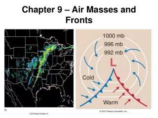
Fronts A Front - is the boundary between air masses; normally refers to where this interface intersects the ground (in all cases except stationary fronts, the symbols are placed pointing to the direction of movement of the front Warm Front Cold Front Stationary Front Occluded Front
How to find a front • Sharp change in temperature • Sometimes, though… • Sharp change in dew point • Shift in wind direction • “Kink” in isobars
Fronts – Real World http://www.hpc.ncep.noaa.gov/sfc/namussfcwbg.gif
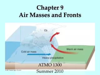
Cold fronts • “Dome” of dense cold air is replacing warm air • Leading edge of the cold front is steep – often leads to strong upward motion
Warm fronts • Warm air replacing cool air • Relatively gentle slope – leads to broad area of upward motion • Warm fronts usually move slower than cold fronts
Stationary fronts • Name is self-explanatory: doesn’t move much • In some cases where air is moist on both sides, stationary fronts can lead to flooding – rain forms along front and persists for many days
EXTREME WEATHER • Warm Fronts and Ice Storms • Warm front with wave like shape in Southeast • Shallow layer of cold air • Known as “Cold Air Damming” • Rain freezes
FRONTS • Occluded Front • Cold front “catches up to” and overtakes a warm front • Purple line with purple triangles and semi-circles • Cold occlusion, warm occlusion
FRONTS • Upper-Air Fronts • Front aloft • Tropopause dips downward and folds under the Polar jet • Impacts surface weather
Other boundaries • Dryline: Boundary between really hot, dry air and warm, moist air (separates cT and mT) • Sets up in southern Plains very regularly • Severe storms often form on dryline • Pressure trough: There’s a “kink” in the isobars, but very little temperature gradient