Download
1 / 14
140 likes | 238 Views
Detailed regulations & requirements for property development on SW 46th Ave in City, adhering to street safety standards. Appeal process & zoning info included.

E N D
Infiltration is very unlikely in this area. • There is no storm-only sewer in front of the property. • Stormwater flows north. • The closest storm sewer and most likely disposal point is at the intersection of SW Garden Home and SW 45th. Public Stormwater
Code/Administrative Rule being appealed: 17.88.020 A. No single family, multiple dwelling, industrial or commercial building shall be constructed, or altered so as to increase its number of occupants, or make significant alterations to a building without resulting in increased occupancy, on property that does not have direct access by frontage or recorded easement with not less than 10 feet width of right‑of‑way to a street used for vehicular traffic. B. If such street or any other street adjacent to the property used for vehicular access for said property does not have a standard full width improvement, including sidewalks, the owner as a condition of obtaining a building permit, conditional use, zone change, land partition or adjustment, shall provide for such an improvement or a portion thereof as designated by the City Engineer, in accordance with provisions elsewhere in this Title. C. Based on findings that a standard improvement is not feasible, the City Engineer may allow a temporary improvement appropriate for the circumstances, on the condition that the City will not maintain said temporary improvement and the owner will provide the City with a notarized document, approved as to form by the City Attorney, to be filed with the County in which property is located, stating that the present and future owners will be counted in favor of any proposed standard improvement of said street. Fee for said filing and any other expense of the City incidental to accomplishing the temporary improvement shall be paid by the owner.
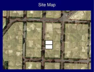
Bureau Requirements and Findings At this location SW 46th Ave is classified as a Local Service Street for all modes. It is a 50-ft wide ROW. It is improved with approximately 16-ft of paving not maintained by the City. Dedications cannot be required for the southern lot with the replacement residence. A 2-ft dedication will be required for the newly created vacant lot on the north. Standard frontage improvements will be required for each lot. The improvements will have to be modified for the southern lot to fit within the existing ROW. The improvement will include a minimum 20-ft or roadway, curb 13-ft from the ROW centerline, 8-ft public stormwater swale, 5-ft sidewalk, and a 0.5-ft frontage zone between the back of the sidewalk and the property line. The site and block are zoned single-family (R7). SW 46th does not connect to SW Multnomah approximately 1,000 feet to the north. There is an indirect connection to SW Multnomah via SW 45th Avenue one block to the east. The closest sidewalk segments are located on SW Multnomah Ave.
Appellants Alternative • Construct a 6-ft sidewalk within the existing right-of-way
The appellant has raised concerns that the City’s requirements may not meet the Nolan and Dolan nexus and rough proportionality tests. In our review of the requirements the dedications required by the City appear to be roughly proportional to the traffic impacts the development will place on the local transportation system. For projects with replacement homes the new home will continue to provide impacts on the transportation system that have not been mitigated to date. Construction costs related to the individual frontage improvements along the transportation corridor appear to be proportional to the improvements that would be required of other lots along the corridor based on our analysis. Essentially, PBOT is not asking for the appellant to make improvements beyond the appellants site frontage. At this time however, a concept stormwater disposal design has not been prepared and submitted for review by the City and we are unable to assess whether those elements may include off-site improvements. Without a concept to consider it is difficult to assess whether those improvements would be roughly proportional to the impact of the appellants project.
Summary of Regulatory Framework for Requiring Street Improvements Oregon’s Statewide Planning Goals & Guidelines, Goal 12: Transportation Provide and encourage a safe, convenient and economic transportation system. The Transportation Planning Rule and Metro’s Regional Transportation Plan requires local jurisdictions to provide for safe and convenient pedestrian, bicycle and vehicle circulation. Goal 6 of the City’s Comprehensive Plan and Transportation Element (TE) supports this goal through policy language.Within Goal 6 are sets of street classification maps, which guide the use of the transportation system. (Street Improvements include all needed public infrastructure including, but not limited to, roadways, curbs, sidewalks, street trees, street lighting, water, sanitary and storm water systems.)
The following is a partial list of codes, manuals other documents used in the street design process: Title 17 of the City Code – Public Improvements (City of Portland) Creating Public Streets and Pedestrian Connections through the Land Use and Building Permit Process (City of Portland) Pedestrian Master Plan (City of Portland, 1998) Pedestrian Design Guide (City of Portland, 1998) Portland Bicycle Plan for 2030 (City of Portland, 2010) Design Guide for Public Street Improvements (City of Portland, 1993, Updates expected in 2011) Stormwater Management Manual (City of Portland, 2008) Freight Master Plan (City of Portland, 2006) A Policy on Geometric Design of Highways and Streets (American Association of State Highway and Transportation Officials) AASHTO Guide for Design of Pavement Structures (American Association of State Highway and Transportation Officials) Manual on Uniform Traffic Control Devices (Federal Highway Administration) Standard Construction Specifications (City of Portland) Various street master plans and design district plans
Decision for Panel • The question before the Panel is whether the bureaus’ decisions: • Are inconsistent with or contrary to City Code, rules, standards or policy; or • The bureau has misapplied or misinterpreted City Code, rules, standards, or policy. • The Panel can: • Approve the requested relief, • Approve the requested relief with conditions, or • Deny the requested relief, • provided that any decision made must be consistent with applicable City Code, rules, standards and policies. • The motion must include the basis of the Panel’s decision. • Decision:


![[Project Name] Site Map version xx-xx-xx](https://cdn1.slideserve.com/3222395/slide1-dt.jpg)