Download
1 / 1
10 likes | 89 Views
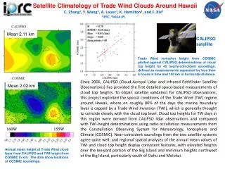
Study compares CALIPSO cloud top heights with Trade Wind Inversion heights around Hawaii, with consistent findings regarding cloud levels over the region. The analysis leverages satellite data since 2006 to validate CALIPSO observations.

E N D
Satellite Climatology of Trade Wind Clouds Around Hawaii C. Zhang1, Y. Wang1, A. Lauer1, K. Hamilton1, and F. Xie2 1IPRC, 2NASA JPL Mean 2.11 km CALIPSO satellite Trade Wind inversion height from COSMIC plotted against CALIPSO determinations of cloud top height for 45 nearly-coincident soundings, defined as measurements separated by less than 6 hours in time and 100 km in horizontal distance. Since 2006, CALIPSO (Cloud-Aerosol Lidar and Infrared Pathfinder Satellite Observations) has provided the first detailed space-based measurements of cloud top heights. To obtain satellite validation for CALIPSO observations, this project exploited the special conditions of the Trade Wind (TW) regime around Hawaii, where on roughly 80% of the days the marine boundary layer is capped by a Trade Wind Inversion (TWI), which is generally thought to coincide closely with the cloud top level. Cloud top heights for TW days in this region were derived from CALIPSO lidar observations and compared with TWI-height determinations using radio occultation measurements from the Constellation Observing System for Meteorology, Ionosphere and Climate (COSMIC). Near-coincident soundings from the two satellite systems agree quite well, and regional spatial analyses of the annual mean values of TWI and cloud top height display consistent features, with elevated heights over the leeward portion of the Big Island and minimum heights northwest of the Big Island, particularly south of Oahu and Molokai. Mean 2.02 km Annual mean height of Trade Wind cloud layer from CALIPSO and TWI height from COSMIC in km. The dots show locations of COSMIC soundings.