Download
1 / 39
430 likes | 843 Views
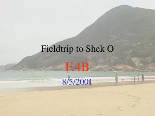
OXE1002/1003 Cwm Idwal Fieldtrip. Y Garn. Cwm Clyd. Cwm Cywion. Llyn Bochlwyd. Cwm Idwal boundary. Nant Ffrancon. Route followed around Llyn Idwal. Cwm Idwal. Tryfan. Carneddau. Llyn Ogwen.

E N D
Y Garn Cwm Clyd Cwm Cywion Llyn Bochlwyd Cwm Idwal boundary Nant Ffrancon Route followed around Llyn Idwal Cwm Idwal
Tryfan Carneddau Llyn Ogwen The aim of the Cwm Idwal fieldtrip is to introduce students following Earth Science modules OXE1002 and OXE1003 to the mountainous landscapes of Snowdonia and, specifically, to observe a range of geological, geomorphological and pedological (soils) features which illustrate principles covered in these modules. These features include rocks and structural features associated with subduction zones in the distant geological past, including explosive volcanism, orogenesis (mountain building), tectonism (folding); landscape features associated with glaciation in the recent geological past ; and different soil types which illustrate the influence of geology and geomorphology on pedogenesis.
Cwm Idwal is a National Nature Reserve and therefore has high conservation status. The reasons why this locality has such importance are: 1. botanical, 2. geological and 3. geomorphological. In addition, Cwm Idwal has been visited, and has influenced, the developing ideas of many of the most significant individuals in the history of natural science. For natural scientists, Cwm Idwal is a site of international importance.
Headwall ledges in Cwm Idwal support communities of arctic-alpine species, such as the Snowdon lily (Lloydia serotina), and species of saxifrage, which have flourished here since the end of the last cold (glacial) stage, 11,500 years ago. The reason that these plants have been able to survive in this environment is that these ledges, with their poor thin soils and restricted space, have never been colonised by warmth-demanding shrubs and trees in the temperate climate since the last Ice Age. The arctic-alpines have therefore not been out-competed by shading, to which these plants are particularly susceptible, as they have in less inaccessible habitats.
In the early 1800’s geologists all over Britain and in parts of continental Europe started to map the surface distribution of rocks following the pioneering work of the engineering geologist William Smith (see Winchester, 2002). In North Wales, the Revd. Adam Sedgwick, the first Professor of Geology in the University of Cambridge, started to map the rocks to the north of Cwm Idwal in the late 1820’s and early 1830’s. He coined the term Cambrian to describe the age of these rocks; the absolute age of these rocks (which we now know to be over 500 million years old) was unknown to Sedgwick because techniques of radiometric dating did not develop for well over another hundred years. These Cambrian rocks include the famous slates which outcrop around the northern flank of Snowdonia and which have been quarried here for roofing materials for several centuries. The term Cambrian, now used globally to denote the period between 510 and 543 Ma, was therefore first proposed in this area.
At the same time that Sedgwick was mapping in North Wales, his colleague Sir Roderick Murchison (later Director of the Geological Survey) was mapping in the Welsh borderlands with England. He introduced the term Silurian (from an ancient Iron Age tribe, the Silures, who formerly lived in the region) to describe the age of the rocks in his area. Murchison, as he mapped westwards into North Wales, realised from the stratigraphy of the different beds that the rocks were becoming progressively older. In Snowdonia he described the rocks as Lower Silurian. Sedgwick, conversely, realised that as he mapped southeastwards, the rocks were becoming progressively younger and described the sequences in the vicinity of Cwm Idwal as Upper Cambrian. Sedgwick and Murchison fell out over this semantic controversy; the situation was only resolved some years later by the intermediary Lapworth (first Professor of Geology in the University of Birmingham) who proposed the separate term Ordovician (again from an ancient tribe, the Ordovices) to describe the overlapping rock series. All three basal periods of the Palaeozoic Era, the Cambrian, Ordovician and Silurian (in age order) were therefore first described in the 1800’s in this area.
The Ordovician rocks in Cwm Idwal are predominantly felsic (silicic) extrusive igneous in origin, consisting of alternations of rhyolite, volcaniclastic ash beds and ignimbrites. The rhyolites are fine-grained (extrusive) and light-coloured (felsic). Ignimbrites are ash-flow pyroclastic rocks formed when still partially molten glass shards and other ejecta fall to the ground, fuse, collapse and weld together to give a pseudo-laminated appearance. rhyolite ignimbrite rhyolite The felsic extrusive igneous and volcaniclastic rocks found in Cwm Idwal are typical of destructive plate margins. Such rocks are associated with violent eruptions of highly viscous acid lava through volcanoes situated above subduction zones in which magma has been produced through the melting of both oceanic (mafic) and continental (silicic) crust. In the Ordovician, an oceanic plate associated with the Iapetus Ocean was subducting beneath the adjacent continental plate in this area.
This is the tectonic setting for the Ordovician sequences observed in Cwm Idwal. The Cambrian slates which outcrop to the north of Cwm Idwal represent low grade metamorphism of marine muds which accumulated on the floor of the closing Iapetus Ocean.
This diagram shows the position as Iapetus gradually closed as a result of continued subduction. The continent to the left is moving towards the continent to the right. Iapetus has now disappeared through continued subduction beneath the continent to the right, and the continents have collided. This causes deformation and metamorphism of the Iapetus sediments (e.g. Cambrian slates) and mountain building (orogenesis). Snowdonia was first uplifted through this process during the Ordovician and would have resembled a mountain chain such as the Himalaya prior to weathering and erosion. The existing uplands represent the eroded remnants of these earlier mountain ranges.
Devil’s Kitchen syncline The syncline (down-fold) exposed in the headwall at Cwm Idwal is an example of the folding and deformation that occurred in the continent-continent collison as Iapetus disappeared. This synclinal structure, the Snowdon Syncline, is a major tectonic featurewith an axis which trends from NE to SW through Snowdonia, plunging to the NE. The axis of the syncline in Cwm Idwal is marked by the Devil’s Kitchen. In the Snowdon group it is exposed towards the summit of Snowdon itself.
Devil’s Kitchen Idwal slabs
The Idwal slabs mark the left hand (southeast) limb of the syncline. The dip of the rocks to the right is clear. Note size of climbers for scale.
On a mapping visit to North Wales in August 1831, Sedgwick was assisted by a young student from Cambridge eager to learn the practical skills of field geology and mapping. This student was Charles Darwin. They worked together in the mountains for some days before Sedgwick had to depart for a prior engagement in Dublin. Presumably Sedgwick travelled by stage coach down the new road constructed by Thomas Telford to link London with Holyhead (now known as the A5) and crossed the Menai Strait by way of the new Suspension Bridge (opened in 1826). Darwin returned on his own to Cwm Idwal and recorded observations of the rocks and structures in his notebook. He then walked to Barmouth overland to meet up with friends who were having a house party there. On returning to his parents’ home in Shrewsbury after this visit he found a letter waiting for him from John Stevens Henslow, Professor of Botany in the University at Cambridge, containing the suggestion that he accept an invitation to join HMS Beagle and accompany the Captain, Robert FitzRoy, on a voyage to South America and, ultimately around the world. Darwin eventually accepted this invitation which took him away from Britain from 1831 until 1836. It was on this voyage that Darwin recorded many of the observations of the natural world that laid the foundations for what was to become possibly the most important and controversial book on natural science ever published - The Origin of Species (1859). But Darwin was to return to Cwm Idwal after the voyage...
While Darwin was away on the Beagle, a quiet revolution had occurred in geology. Prior to the 1830’s, the accepted explanation for the form of the earth’s surface and for unconsolidated surficial sediments was that they had been fashioned by Noah’s Flood - the Diluvial Theory. But in the 1830’s a Swiss geologist - Louis Agassiz - based on observations from Alpine valleys, suggested that glaciers were not fixed in space and had at some point in the recent geological past been much more extensive. He attributed many features in the Swiss landscape to erosion and deposition by glaciers in a recent Ice Age. This became known as the glacial theory. Agassiz travelled all over Europe in pursuit of fresh observations to substantiate his hypothesis. He introduced Britain to the glacial theory in 1840, and soon Cwm Idwal was visited by some of the most important British geologists of the day, including Dean Buckland and Sir Andrew Ramsay, eager to compare the British evidence with the features that Agassiz had described. At first many remained sceptical, or even hostile to the new theory. Darwin returned in 1836 to an atmosphere of feverish debate about this new glacial theory. This resonated with his new first -hand experiences and observations of glaciers in and around the Beagle Channel in southernmost Patagonia. As he reminisced about his 1831 tour in his autobiography written at the end of his life: “On this tour I had a striking instance how easy it is to overlook phenomena, however conspicuous, before they have been observed by anyone. We spent many hours in Cwm Idwal, examining all the rocks with extreme care, as Sedgwick was anxious to find fossils in them; but neither of us saw a trace of the wonderful glacial phenomena all around us; we did not notice the plainly scored rocks, the perched boulders, the lateral and terminal moraines. Yet these phenomena are so conspicuous that, as I declared in a paper published many years afterwards in the Philosophical Magazine, a house burnt down by fire did not tell its story more plainly than did this valley. If it had still been filled by a glacier, the phenomena would have been less distinct than they now are“. He set to work to write up his Cwm Idwal observations in the light of the glacial theory and this became his first published scientific paper, in 1842. As you walk around Cwm Idwal you are following in the footsteps of one of the greatest of scientists. Furthermore, it is a place which had a profound influence on his thinking at the most formative time in his life. Cwm Idwal therefore ranks as one of the most important sites in the history of natural science.
What, then, are the features indicative of former glaciation in and around Cwm Idwal which so impressed Darwin? The glacial landforms which make up this glaciated landscape fall into two main categories: landforms of glacial erosion and landforms of glacial deposition. Landforms of erosion occur where processes of glacial erosion, such as abrasion, have created distinctive forms in the bedrock, and landforms of deposition occur where glaciers have deposited material transported by the glacier. These occur at a variety of scales, from microscale features such as striations, to macroscale features such as the glaciated trough of Nant Ffrancon (U-shaped valley); the smaller scale features are nested within the larger scale features.
nunatak - Y Garn Macroscale features Directions of ice flow cwm (corrie) - Cwm Clyd cwm (corrie) - Cwm Idwal cwm (corrie) - Cwm Cywion rock basin (occupied by Llyn Idwal) arête trough (U-shaped valley) - Nant Ffrancon rock step (separating Cwm Idwal from Nant Ffrancon) Landforms of glacial erosion
Nunataks are pyramidal peaks of bedrock left unglaciated at elevations above the regional ice sheet surface. They have not been subject to glacial erosion but extreme physical weathering through frost-heave, usually generating highly angular clastic debris as can been at the summits of Y Garn and on the Glyderau. This modern example is from Alaska.
Cwms (corries) are glacially eroded rock basins in mountainous areas representing the sites of snow accumulation and early ice growth. They are often located on east or northeast facing slopes because this is where snow, blown by prevailing southwesterly winds, accumulates in the lee of ridges. These slopes are also most shaded from the sun; this minimises snow melting and so enhances glaciation.
The southwest (northeast facing) side of Nant Ffrancon features eight cwms (corries) extending from Cwm Idwal in the southeast to Cwm Ceunant in the northwest. No such cwms are found on the northeast (southwest facing) side of the valley. The glacial erosion of these cwms has been facilitated through the joint and discontinuity patterns in the underlying rock masses which has made the western side more susceptible to erosion than the eastern side.
Pen-yr-Ole-Wen The northeastern side of Nant Ffrancon has not been sculpted into a series of corries, due to prevailing wind, aspect (slope orientation) and geological structure NANT FFRANCON Corries on the southwestern side of Nant Ffrancon as viewed from the Glyderau
The rock-step separating the basin of Cwm Idwal from the trough of Nant Ffrancon
The glaciated trough (U-shaped valley) of Nant Ffrancon The floor of Nant Ffrancon is flat - rather than forming a perfect U-shaped cross-profile - because two ribbon lakes filling shallow basins in the valley floor, which formed as soon as the glacier filling the trough melted, have filled up with sediment over the last 14,000 years. Surface of infilled lake sub-lake cross-profile
This view of the Kaskawulsh Glacier in Alaska is a good analogue for how Nant Ffrancon would have appeared 21,000 years ago
This view of the Llanberis valley to the west illustrates how Nant Ffrancon would have appeared before the ribbon lakes filled in. These lakes in Llanberis (Llyn Peris and Llyn Padarn) are much deeper than either of the two lakes that formerly existed in Nant Ffrancon explaining why they have not yet disappeared.
Mesoscale features Whaleback features and roches moutonnées on the rock-step Landforms of glacial erosion
Direction of ice flow Smooth, streamlined, up-glacier surfaces Fractured, irregular, plucked lee-side surfaces Roche moutonnée on the rock-step
Microscale features of glacial erosion - striations Striae are not well exposed in Cwm Idwal but these excellent examples are from the rock floor of Llyn Peris when it was drained during the construction of the Dinorwig Power Station
The hummocky moraine delineates the margins of a former glacier restricted to the area between the moraine and the cwm headwall. This cwm glacier clearly post-dated the Last Glacial Maximum (21,000 years ago) since these landforms of deposition would have been destroyed by a major ice cap. hummocky moraine Landforms of glacial deposition
Views of the Cwm Idwal hummocky moraine belt. These features were the focus of Darwin’s 1842 paper.
This diffuse moraine ridge on the slope marks the maximum position of the cwm glacier and subsequent ridges its retreat phases Limit of moraine belt
… but the outer part of Llyn Idwal remained unglaciated During the cwm glaciation this area, including the inner part of Llyn Idwal, were covered in ice
Landforms of glacial deposition Sediment cores from the inner part of Cwm Idwal indicate active lake sedimentation after 11,500 years ago... The Younger Dryas Event was caused by a ‘shutdown’ in the North Atlantic meridional overturning circulation (thermohaline circulation). One suggestion for the cause of this shutdown was the cessation of convective sinking of cold, dense, water north of Iceland because of the discharge of huge quantities of light freshwater into the North Atlantic from the rapidly melting Laurentide Ice Sheet covering North America. The Younger Dryas saw the most recent glaciers in the British Isles, including a small ice cap in Scotland. This cold event followed a phase of rapid warming which had caused the total disappearance of ice from Britain after 16,000 years ago. The linkage between the glaciation of Britain and the circulation of the North Atlantic demonstrates how sensitive our climate is to ocean heat transport. …whereas cores from the outer part of Llyn Idwal have a much longer sequence, extending back beyond 14,000 years. This helps to confirm that the Idwal moraines date to the Younger Dryas Event, a cold ‘blip’ lasting about 1,000 years, from 12,600 to 11,500 years ago.
BUT, WHAT IS THIS…? Gley soils, also acidic, characterise alluvial fans draining into Llyn Idwal. These characteristically grey-orange mottled soils form in response to cyclic waterlogging (winter) and drainage (summer). Iron oxidises to orange during drainage, but reduces to grey during saturation Brown podsols, also acidic, are confined to the moraine belt because groundwater is able to drain freely through the sediments forming the moraine Acidic peaty ranker soils occur on bare bedrock and grade into peat in waterlogged areas. These soils are largely organic and consist of humus which has accumulated on bare rock surfaces Soils in Cwm Idwal Soils in Cwm Idwal are profoundly influenced by parent materials and geomorphology...
The soils on this particular alluvial fan are not acid gleys, like the neighbouring fan, because they are continuously replenished with base-rich minerals by a stream eroding mafic igneous rocks exposed in the Devil’s Kitchen in the core of the Snowdon Syncline. The neighbouring stream drains exclusively over acidic rhyolites, ashes and ignimbrites. It’s a mole-hill, which means there must be moles, which means there must be earthworms, which means that the soil must be neutral or base-rich. Yes, this is a Brown Earth, occuring as an island within a sea of acidic soil. Why…?
Written by James Scourse (2003) With acknowledgements to: David Roberts, David Jenkins, Peter Coxon and Tonya O’Donnell for photographs, and to the Countryside Council for Wales for the photograph of Lloydia serotina. Some figures from Press and Siever (Understanding Earth, 3rd. Ed., 2000) FURTHER READING Addison, K. 1997. Classic glacial landforms of Snowdonia. GA, BGRG, 60pp. Addison, K., Edge, M.J. & Watkins, R. 1990. North Wales. Field Guide. Quaternary Research Association, London, 190pp. Darwin, C. 1842. Notes on the effects produced by the ancient glaciers of Caernarvonshire, and on the boulders transported by floating ice. Philosophical Magazine 21, 180-188. Winchester, S. 2002. The map that changed the world. HarperCollins Paperback.