Download
1 / 5
50 likes | 190 Views
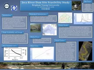
The Team:. Joca River Dam Site Feasibility Study Brigham Young University in collaboration with INDRHI. Logan Palmer Stephen Bolster Lindsey Cahoon Garrett Frame Erick Conde Sandra Jose Clases Australia Ramirez Garcia Dr. Nelson. Watershed Characteristics:. Introduction:.

E N D
The Team: Joca River Dam Site Feasibility Study Brigham Young University in collaboration with INDRHI Logan Palmer Stephen Bolster Lindsey Cahoon Garrett Frame Erick Conde Sandra Jose Clases Australia Ramirez Garcia Dr. Nelson Watershed Characteristics: Introduction: Using WMS we were able to determine the area of our watershed to be 220 km2 . Using the data provided to us we determined that the yearly average precipitation for this watershed is 82 mm. The River Joca in the Dominican Republic runs through the South Western portion of the country near to the border of Haiti. For our project, we worked together with the Dominican Republic’s national water agency, INDRHI, to determine whether or not it would be feasible to put a dam in the river that would provide irrigation water, hydroelectric power, and flood protection. Storm Models To create a model for the watershed WMS and HEC-HMS was utilized. Inputs for this model included a 30 meter DEM, Shape files of Land Use, and Soil Type. These were used to develop a curve number for the basins. The watershed was divided into 8 sub basins to more accurately route runoff to the outlet. The model was run using the precipitation return periods as well as the PMP storms. When run in HMS the hydrographs in the figure above were developed. Water Availability and Storage The yield for the reservoir requires a monthly average of 7 cms. This comes from 3.6 cms that would be required for irrigation for the desired 2000 hectares in SabanaMula, 3 cms for the 80% normal flow-rate out of the dam from the flow duration curve, and .4 cms from evaporation and other factors. Hydro Power: Using the turbine output equation we determined the output energy to be 5.7 GW-hr./year. Flood Control: A GSSHA model was utilized to provide flood data for the inhabited area downstream of the dam. The stream channel cross-sections between the dam and the cities of Pedro Santana and Banica were determined using Google Earth. A fixed discharge at different levels was released from the dam until significant flooding occurred in the cities at 100 cms. A dam failure was simulated with the same GSSHA model. The maximum flooding in the cities from this flood is depicted in the figure to the right. Flow Duration Curve: Mass Curve