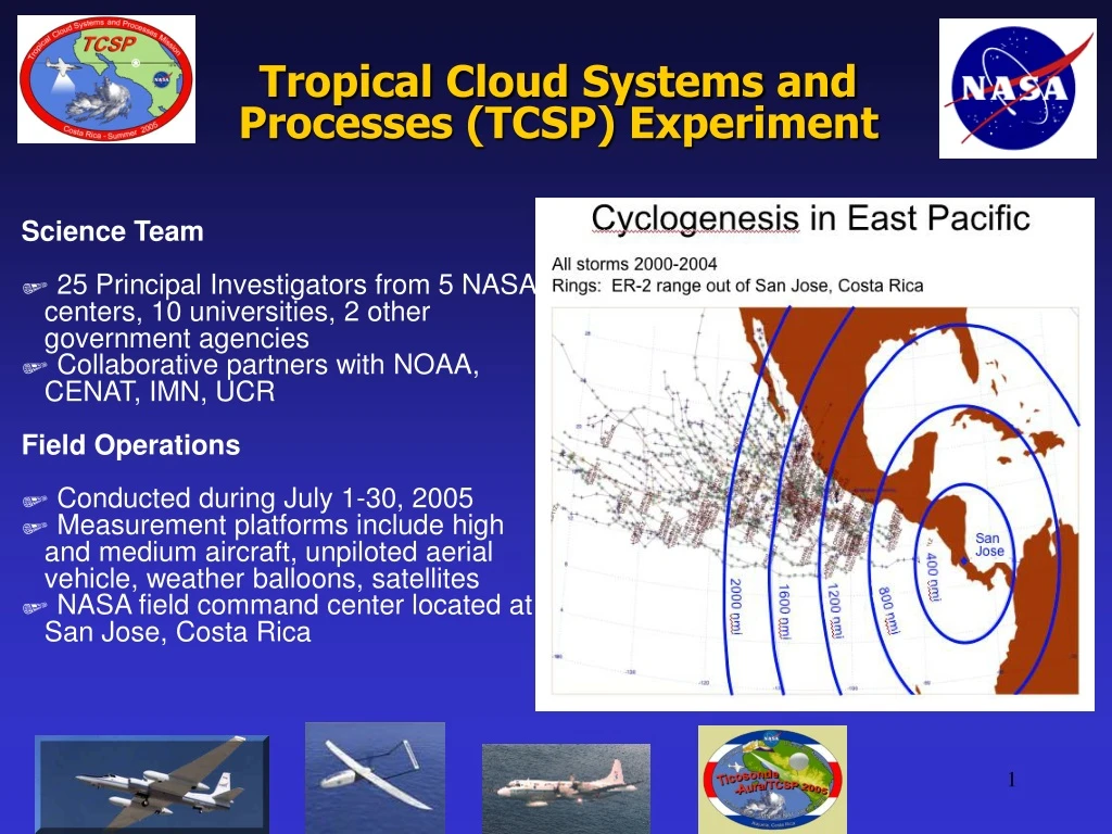
Tropical Cloud Systems and Processes (TCSP) Experiment
70 likes | 84 Views
The TCSP Experiment aims to improve our understanding and prediction of tropical cyclones by using remote and in-situ sensing to study genesis, intensity, motion, rainfall potential, and landfall impacts. With a team of 25 Principal Investigators from NASA, universities, and government agencies, the experiment was conducted in July 2005 using various measurement platforms including aircraft, balloons, and satellites.

Tropical Cloud Systems and Processes (TCSP) Experiment
E N D
Presentation Transcript
Tropical Cloud Systems and Processes (TCSP) Experiment Science Team 25 Principal Investigators from 5 NASA centers, 10 universities, 2 other government agencies Collaborative partners with NOAA, CENAT, IMN, UCR Field Operations Conducted during July 1-30, 2005 Measurement platforms include high and medium aircraft, unpiloted aerial vehicle, weather balloons, satellites NASA field command center located at San Jose, Costa Rica
CAMEX-3 Inner core dynamics Synoptic flow environment Landfalling intensity change Genesis environment CAMEX-4 Rapid intensification Storm movement Structure and dynamics Scale interactions Remote sensing techniques Evolution of TCSP Research Goals Improve the understanding and prediction of tropical cyclone genesis, intensity, motion, rainfall potential, and landfall impacts by remote and in situ sensing of three phases of water from spaceborne and airborne platforms
NASA Hurricane Science: Three Prongs 1. Satellite Remote Sensors 2. Field Campaigns to Investigate Hurricanes 3. Numerical Models NOAA P3 NASA ER-2 Aerosonde
NASA Satellites: TRMM Hurricane Isabel, Atlantic, 2003 Composite of TRMM VIRS, TMI, PR
NASA Satellites: QuikSCAT Hurricane Howard, EPAC, 2004
Advanced Microwave Precipitation Radiometer NASA ER-2: Virtual Satellite Lightning Imaging Sensor MODIS TRMM Microwave Imager Precipitation Radar ER-2 Doppler Radar AMSR-E
NASA Hurricane Science: Three Prongs 1. Satellite Remote Sensors 2. Field Campaigns to Investigate Hurricanes 3. Numerical Models NOAA P3 NASA ER-2 Aerosonde