Download
1 / 12
140 likes | 362 Views
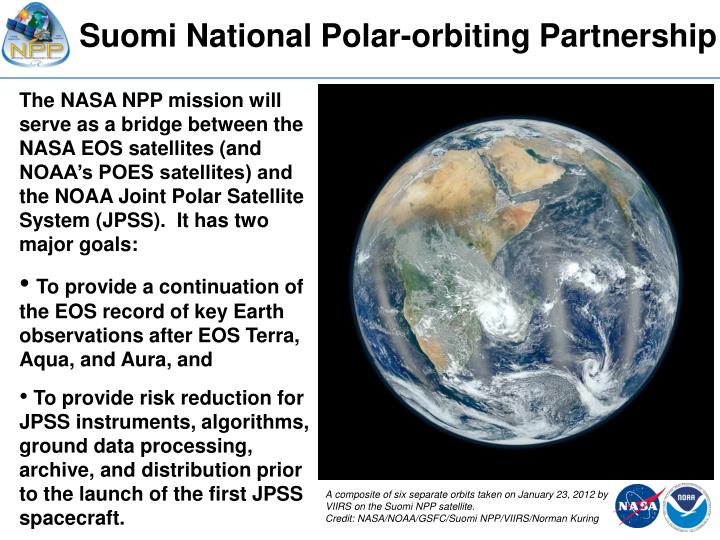
Suomi National Polar-orbiting Partnership. The NASA NPP mission will serve as a bridge between the NASA EOS satellites (and NOAA’s POES satellites) and the NOAA Joint Polar Satellite System (JPSS). It has two major goals:

E N D
Suomi National Polar-orbiting Partnership • The NASA NPP mission will serve as a bridge between the NASA EOS satellites (and NOAA’s POES satellites) and the NOAA Joint Polar Satellite System (JPSS). It has two major goals: • To provide a continuation of the EOS record of key Earth observations after EOS Terra, Aqua, and Aura, and • To provide risk reduction for JPSS instruments, algorithms, ground data processing, archive, and distribution prior to the launch of the first JPSS spacecraft. A composite of six separate orbits taken on January 23, 2012 by VIIRS on the Suomi NPP satellite. Credit: NASA/NOAA/GSFC/Suomi NPP/VIIRS/Norman Kuring
Suomi NPP: Development, Launch and Activation Phases • NASA NPP Project • Project Management • Spacecraft & Integration • ATMS • CERES • Launch Vehicle • Science Data Segment • Mission Systems Engineering • Mission Integration • JPSS Program • VIIRS • CrIS • OMPS • Ground System • Mission Operations • NOAA • Archive & Distribution Segment (ADS) • NPOESS Data Exploitation (NDE)
Suomi NPP: Responsibilities Post Commissioning • JPSS Flight Project • S/C Post Delivery Support (PDS) • VIIRS, CrIS, ATMS, OMPS PDS • JPSS Ground Project • Mission Management • Mission Systems Integration • C3S Sustainment/Enhancement • IDPS Sustainment/Enhancement • FVS Sustainment/Enhancement • Cal/Val and Algorithm Updates • Mission Operations • NASA GSFC, LaRC • CERES PDS & Product Generation • OMPS Limb Product Generation • Science Data Segment Ops/Sustainment • Science Support • NOAA • Archive & Distribution Segment (ADS) / CLASS • Operations Management (post on-orbit risk reduction)
JPSS Ground System Evolution and Suomi NPP – On Orbit Mission Phases NPP LRD NPP EOL Transition to Routine Ops Operations Block 1.5 Risk Reduction Block 1.2.2 Block 1.2.3 Block 1.3 Commissioning De-Commissioning • Block 1.2.1 Launch L+3 mos L+7 mos L+15 mos L+24 mos L+30 mos L+5 yrs Commissioning LEO S/C Activation Instrument Activation Sat Maneuver Verification Sat On-orbit Perf Evaluation Risk Reduction Fixes / Enhancements Intensive Cal/Val Algorithm Fixes Cal / Characterization Maneuvers Operations Team Integration CGS PerformanceTuning CGS Performance Eval Tech Refresh Security Updates Separate Operating Environs Operations Nominal Operations Security Monitoring / Maintenance Ops Sustainment Long Term Monitoring & Trending Routine Cal Updates Periodic Cal Maneuvers De-commissioning Sat Health & Propellant Monitoring De-orbit Planning / Script Controlled De-orbit
Suomi NPP: NASA Science Team (36 members) • The Suomi NPP Science Team was re-competed in ROSES-2010; its research is focused on supporting work to ensure the continuity of scientific data records started in the EOS era. • The Suomi NPP Science Team’s work on data products will focus on SDR and EDR evaluation and, if needed, improvement.* Science Team recommendations for algorithm improvement will forwarded to JPSS/NOAA through the NPP Project Science Office. • The Suomi NPP Science Team has 5 subgroups working together: -- VIIRS Cloud/Aerosol -- Ozone -- VIIRS Land -- Sounder -- VIIRS Ocean • A few Suomi NPP Science Team members are working on cal/val support activities or the conceptual basis for new products. • * Exceptions: CERES data products will be produced and archived by existing CERES team and OMPS Limb data products will be developed, produced, and archived by NASA/NOAA Ozone Team.
NOAA and NASA Data Activities for Suomi NPP • NOAA JPSS Algorithm Cal/Val Teams and Comprehensive Large Array-data Stewardship System (CLASS) • Scientific support for operational generation of NPP/JPSS sensor data records (SDRs) and Environmental Data Records (EDRs) • Cal/val of the Interface Data Processing Segment (IDPS) generated SDRs and EDRs and ownership of the algorithms for future upgrades, and provides long-term science maintenance (validation and improvements). • Infrastructure: GRAVITE (mini – IDPS, local archive, subscription services to cal/val teams) and CLASS for permanent archive. • NASA Suomi NPP Project Office, Science Team, and Science Data Segment (SDS) • Evaluation of the IDPS-generated SDRs and EDRs as to their suitability as Earth system / climate data records. • If warranted, the Suomi NPP Science Team will develop, test, and recommend algorithm improvements. • Infrastructure: SDS includes mini-IDPS, local archive, and Product Evaluation and Analysis Tool Elements (PEATEs).
Suomi NPP: NASA PEATES As part of its Science Data Segment (SDS), NASA has developed several disciplinary Earth science Product Evaluation and Analysis Tool Elements (PEATEs) to support Suomi NPP Science Team members and the NPP Project staff in their evaluation of the EDRs and SDRs The PEATEs provide functions for the Suomi NPP Science Team and the NPP Instrument Calibration Support Element (NICSE) in support of their goals to evaluate SDR and EDR performance and to assess the suitability of operational EDRs for use in climate analyses. The PEATEs also support development and testing of improvements to the operational algorithms which generate SDR and EDR products in the IDPS.
NPP Instrument Calibration Support Element (NICSE) NASA SDS Element Architecture Overview Government Resource for Algorithm Verification Independent Testing & Evaluation (GRAVITE) Ozone Limb Community Sounder Product Evaluation & Analysis Tool Element (PEATE) Archive & Distribution Segment (ADS) / CLASS SDS Data Distribution & Depository Element (SD3E) Limb SDR (EV+CAL) and EDR Ozone Product Evaluation & Analysis Tool Element (PEATE) Interface Data Processing Segment (IDPS) Atmosphere Product Evaluation & Analysis Tool Element (PEATE) OMPS Limb RDRs Land Product Evaluation & Analysis Tool Element (PEATE) Data flow OMPS Limb Data Flow NPP Science Team Ocean Product Evaluation & Analysis Tool Element (PEATE) VIIRS Cal/Val Interaction EDR assessment CERES RDR, VIIRS SDR, AOT Earth Radiation Budget Climate Analysis Research System (ERBCARS) Science Data Segment CERES Science Community LaRC DAAC The Suomi NPP Science Data Segment is a System of Systems distributed amongst: 9 facilities located at GSFC, JPL, U of Wisconsin, & LaRC 8
NASA Data Policy • NASA promotes the full and open sharing of all data with the research and applications communities, private industry, academia, and the general public (the term 'data' includes observation data, metadata, products, information, algorithms, including scientific source code, documentation, models, images, and research results). • Relevant information excerpted from NASA’s statement at: http://science.nasa.gov/earth-science/earth-science-data/data-information-policy/ • Full and open sharing of Earth science data obtained from NASA Earth observing satellites, sub-orbital platforms and field campaigns with all users as soon as such data become available. [NOTE: This applies to any type of product!] • No period of exclusive access to NASA Earth science data. • NASA will enforce a principle of non-discriminatory data access so that all users will be treated equally. • NASA will make available all NASA-generated standard products along with the source code for algorithm software, coefficients, and ancillary data used to generate these products. [NOTE: At present, NASA has no commitment to generate any Suomi NPP standard products.]
Suomi NPP Data Coordination: Summary • Initial NASA and NOAA roles and responsibilities are fairly clear. • NOAA: Suomi NPP data processing, production, distribution, and archive of SDRs and EDRs; cal/val; consideration of recommended algorithm improvements (this is not anticipated to change through mission life) • NASA: SDR & EDR evaluation; recommend algorithm improvements; scientific support of cal/val; extend EOS time series climate-quality data records • For NASA, mid-term (L + 18 mos.) responsibility is assessment of EDRs and recommendations for improvements and decision(s) on next steps for NASA during prime mission • For NASA, longer term responsibilities are “tbd;” we are expecting to have some, but what they are and • how they will be provided are to be determined
NASA Suomi NPP Earth-Observing Mission • Suomi NPP provides data continuity for NASA, and NOAA, and risk reduction for JPSS instruments, algorithms, ground system, and archive. • Suomi NPP Instruments • Visible Infrared Imaging Radiometer Suite (VIIRS) • Cross-track Infrared Sounder (CrIS) • Advanced Technology Microwave Sounder (ATMS) • Ozone Mapping and Profiler Suite (OMPS), and • Clouds and the Earth's Radiant Energy System (CERES) Only CERES has flown in space before, the other four instruments are new designs. Suomi NPP will continue critical climate and weather data from polar orbit: NASA EOS NOAA POES • AIRS > CrIS • AMSU > ATMS • MODIS > VIIRS • OMI > OMPS • CERES > CERES • HIRS > CrIS • AMSU > ATMS • AVHRR > VIIRS • SBUV2 > OMPS • Anticipated Benefits Tracking Our Changing Climate (measurements to understand climate and the health of our planet) A Vigilant Eye on Ozone (daily measurements to assess recovery of the ozone layer) A Sentinel When Disaster Strikes (wildfires, volcanic eruptions, snowstorms, droughts, floods, hurricanes) Watching the Weather (soundings of atmospheric temperature and moisture, cloud cover) Launch: October 28, 2011