
SURFER
E N D
Presentation Transcript
JEM 209-Doc.Dr. G.Kavusan SURFER WORKING WITH SURFER
Some Features in Surfer 8.0 ========================== - Color rendered 2- and 3- dimentional surface maps. - Overlay raster and vector maps on surface maps. - Grid Mosaic to combine adjacent grids into a single grid file. - Cross-validation to assess the quality of a gridding method. - Map Delaunay Triangles used by Triangulation and Natural Neighbor gridding methods. - Use up to 1 billion data points in the worksheet and when gridding, subject to memory and Windows version requirements. - Generate data and grid statistics reports. - Rotate and tilt raster maps (bitmap base maps, image maps, shaded relief maps). - SRF files are compressed with new bitmap compression routines. - New gridding methods: Moving Average, Local Polynomial. - Data Metrics to calculate spatial data statistics. - Specify Z scale factor in volume calculations when Z units differ from XY units. - Faster loading for large data files by postponing sorting and duplicate checking until gridding begins. - Working with formats: Enhanced Metafile EMF, Golden Software Interchange GSI, ESRI Arc/INFO Export E00. - Exporting in formats: Enhanced Metafile EMF, Golden Software Interchange GSI, MapInfo Interchange Format MIF, Golden Software Boundary GSB. - ANOVA statistics in gridding and variogram reports. JEM 209-Doc.Dr. G.Kavusan SURFER
JEM 209-Doc.Dr. G.Kavusan Installation of Surfer 8.0 • - Windows 98, Me, 2000, XP or higher. • - Windows 95 and NT are not specifically disallowed, but are no longer supported. • - 800 X 600 or higher monitor resolution with support for at least 256 colors • - 20 MB of free hard disk space in the Windows drive. • - 13 MB of free hard disk space. • - At least 8 MB RAM above the Windows requirement for simple data sets. • At least 128 MB of RAM above the Windows requirement for large bitmaps and surface maps recommended. • System Requirements
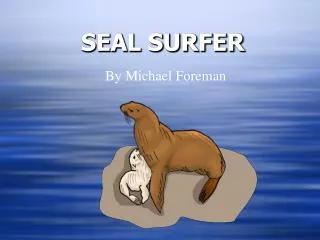
JEM 209-Doc.Dr. G.Kavusan Surfer-overview and examples 3-D modelling of any area, This image of Telluride Colorado It was created in surfer 8
JEM 209-Doc.Dr. G.Kavusan Here is an hydrological example that Interaction of Groundwater and Surface Water
JEM 209-Doc.Dr. G.Kavusan An another 2-D application of surfer, oceanographic mapping of Gulf of Alaska
JEM 209-Doc.Dr. G.Kavusan Surfer-opening page
JEM 209-Doc.Dr. G.Kavusan Surfer-Commands Main frame of surfer program commands 1-plot menu commands on PLOT FILE 2-data menu commands on WORKSHEET FILE 3-node editor commands on PLOT FILE
JEM 209-Doc.Dr. G.Kavusan Surfer –Commands-plot file menu • File Menu Commands • New Creates a new plot document or worksheet • Open Opens a file in a plot document, worksheet, or grid node editor • Close Closes the active document • Save Saves the active document • Save As Saves the active document window in the specified format • Import Imports graphics files • Export Exports graphics files • Page Setup Formats the page for printing • Print Prints the active document • Preferences Sets selected Surfer defaults • Exit Closes Surfer
JEM 209-Doc.Dr. G.Kavusan Surfer –Commands-plot file menu • Edit Menu Commands • Undo Undo the last action • Redo Redo the previously undone action • Cut Cut the selected object to the clipboard • Copy Copy an object to the clipboard • Paste Insert clipboard contents into the document • Paste Special Insert clipboard contents with formatting options • Delete Delete the selection • Select All Select the entire document • Deselect All Deselect selected objects • Invert Selection Reverse the selection • Object ID Changes the name of the selected object • Reshape Move, delete, or insert vertices in a polygon • PropertiesDisplays the properties for the selected object(s)
JEM 209-Doc.Dr. G.Kavusan Surfer –Commands-plot file menu • View Menu Commands • Fit to WindowScale the screen so that all objects are visible • PageShow the full page on screen • Actual SizeView plot at the actual size • Full ScreenFill the entire screen with the document • ZoomZoom realtime, in, out, with rectangles, or on selected objects • Pan RealtimeScroll the window by "grabbing" the contents of the dragging them • RedrawRefresh the image on screen • Auto RedrawTurn redraw on and off • Rulers Show or hide the rulers • Drawing Grid Show or hide the drawing grid • ToolbarsShow or hide toolbars • Status BarShow or hide the status bar • Object ManagerDisplays a list of all objects for editing
JEM 209-Doc.Dr. G.Kavusan Surfer -Commands • Draw Menu Commands • TextCreates a text block • PolygonCreates a polygon • PolyLineCreates a polyline • SymbolCreates a symbol • RectangleCreates a rectangle • Rounded RectCreates a rectangle with rounded corners • EllipseCreates an ellipse
JEM 209-Doc.Dr. G.Kavusan Surfer -Commands • Arrange Menu Commands • Order ObjectsArrange drawing objects with Move to Front, Move to Back, Move Forward, and Move Backward. • Order OverlayArrange an overlay in a composite map with Move to Front, Move to Back, Move Forward, and Move Backward. • Align ObjectsAlign objects horizontally or vertically • Combine Combine selected objects into a single object • Break Apart Break a combined object into multiple objects • Rotate Rotate an object by specific degrees • Free Rotate Rotate an object with the mouse • Transform Move, size, and scale objects, as well as removing transformations with transform
JEM 209-Doc.Dr. G.Kavusan Surfer –Commands-plot file menu • Grid Menu Commands • Data Create a grid from irregularly spaced XYZ data • Variogram Create and save a variogram • Function Create a grid from a user-specified function • Math Provides grid-to-grid and grid-to-constant math operations • Calculus Performs calculus operations on an existing grid file • FilterFilter an existing grid by applying a moving matrix filter • Spline Smooth Smooths an existing grid using cubic splines • Blank Blank grid nodes inside or outside a boundary • Convert Convert between various grid formats • Extract Extract a subset of a grid from an existing grid file • Transform Scale, offset, mirror, or rotate an existing grid file • MosaicCombine a series of compatible input grids into a single output grid • Volume Compute the volume under or over a grid surface • Slice Compute a cross section of data through a grid surface • Residuals Compute the difference between XYZ data and a grid surface • Grid Node Editor Change the values of individual nodes in a grid
JEM 209-Doc.Dr. G.Kavusan Surfer –Commands-plot file menu • Map Menu Commands • Contour Map Create a new contour map, edit labels, export 3D contour lines • Base Map Import a base map filePost MapCreate a new post map or classed post map • Image Map Create a new image map • Shaded Relief Map Create a new shaded relief mapVector Map Create a new vector map from a single grid (aspect and gradient are calculated) or from two grids (X,Y or direction, magnitude) • Wireframe Create a new wireframe • SurfaceCreate a new 3D surface • Scale Bar Add a scale bar to the currently selected map • Digitize Display the coordinates of the selected map in map units and collect data points from the map • TrackballRotate and zoom the selected map in 3D • Stack Maps Align two or more selected maps • Overlay Maps Combine selected maps into the same coordinate system • Break Apart Overlay Break a selected overlay out of a composite map
JEM 209-Doc.Dr. G.Kavusan Surfer –Commands-plot file menu • Window Menu Commands • New Window Opens a duplicate window of the active document. • Cascade Arranges the windows so they overlap. • Tile Horizontal Arranges windows horizontally so there are no overlapping tiles. • Tile Vertical Arranges windows vertically so there are no overlapping tiles. • Arrange Icons Arranges icons at the bottom of the application window.
JEM 209-Doc.Dr. G.Kavusan Surfer –Commands-worksheet file menu • Worksheet File Menu Commands • New Creates a new plot window or worksheet window • OpenOpens a file in the plot window, worksheet window, or grid node editor • Close Closes the worksheet file • Save Saves the active worksheet file • Save As Saves the active worksheet file with a new name • New Worksheet Opens a new worksheet window • Import Combines a worksheet file with the existing worksheet • Page Setup Controls page formatting and printing options • Print Prints the worksheet file contents • Exit Exits Surfer
JEM 209-Doc.Dr. G.Kavusan Surfer –Commands-important and selected worksheet file menu commands • Format Menu Commands • Cell Properties Sets the numeric format, alignment, and background color for the selected cells • Column Width Set column widths for selected cells • Row Height Sets row height for selected cells
JEM 209-Doc.Dr. G.Kavusan Surfer –Commands-important and selected worksheet file menu commands • Data Menu Commands • Sort Sort selected cells • Transform Apply a mathematical transform to columns • Statistics Compute statistics on selected cells
JEM 209-Doc.Dr. G.Kavusan Surfer –Commands-grid node editor menu commands • File Menu - Grid Node Editor • New Creates a new plot document or worksheet • Open Opens a file in a plot document, worksheet, or grid node editor • Close Closes the active document • Save Saves the active document • Save As Saves the active document window in the specified format • Exit Closes Surfer
JEM 209-Doc.Dr. G.Kavusan Surfer –Commands-grid node editor menu commands • View Menu - Grid Node Editor • Fit to Window Scale the screen so that all objects are visible • Zoom In Magnify an area • Zoom Out Minimize an area • Redraw Refresh the image on screen
JEM 209-Doc.Dr. G.Kavusan Surfer –Commands-grid node editor menu commands • Options Menu - Grid Node Editor • Show Contours Show or hide contour lines • Contour Levels Change the display of contour lines • Show Nodes Toggle the display of node symbols • Blank Node Blank the selected grid node • Unblank Node Restore the last blanked grid node • Grid Info Display information about the current grid
JEM 209-Doc.Dr. G.Kavusan Surfer –creating XYZ files • Creating an XYZ Data File • An XYZ data file is a file containing at least three columns of data values. The first two columns are the X and Y coordinates for the data points. The third column is the Z value assigned to the XY point. Although it is not required, entering the X coordinate in Column A, the Y coordinate in Column B, and the Z value in Column C is a good idea. Surfer looks for these coordinates in these columns by default.
JEM 209-Doc.Dr. G.Kavusan Surfer –creating XYZ files
JEM 209-Doc.Dr. G.Kavusan Surfer –creating XYZ files • Opening an Existing Data File • To look at an example of an XYZ data file, you can open TUTORWS2.DAT into a worksheet window: • 1. Choose the File | Open command, to select the XYZ data file. • 2. Double-click on the SAMPLES folder. In the list of files, click TUTORWS2.DAT and then click the Open button to display the file in the worksheet window. • 3. Notice that the X coordinate (Easting) is in Column A, the Y coordinate (Northing) is in Column B, and the Z value (Elevation) is in Column C. Although it is not required, the header text (the text in row 1) is helpful in identifying the type of data in the column, and this information is used in dialog boxes when selecting worksheet columns.
JEM 209-Doc.Dr. G.Kavusan Surfer –creating XYZ files • Saving the Data File • When you have completed entering all of the data: • 1. Choose the File | Save command, or click the button. The Save As dialog is displayed if you have not previously saved the data file. • 2. In the Save as type list, choose the Golden Software Data (*.DAT) option. • 3. Type the name of the file into the File name box. • 4. Click Save and a GSI Data Export Options dialog opens. • 5. Accept the defaults in the GSI Data Export Options dialog by clicking the OK button. • The file is saved in the Golden Software Data [.DAT] format with the file name you specified. The name of the data file appears at the top of the worksheet window.
JEM 209-Doc.Dr. G.Kavusan Surfer -Creating a Grid File • Grid files are required to produce a grid-based map. Grid-based maps include contour maps, image maps, shaded relief maps, 1-grid vector maps, 2-grid vector maps, wireframes, and surfaces. Grid files are created using the Grid | Data command. The Data command requires data in three columns, one column containing X data, one column containing Y data, and one column containing Z data. We have included a sample XYZ data file (sondaj.DAT) with Surfer for you to see how to produce a grid file. After completing the tutorial, if you need to produce an XYZ data file of your data for your work
JEM 209-Doc.Dr. G.Kavusan Surfer -Creating a Grid File • To produce a grid file from .DAT: • 1. If you have the worksheet window open, click on the Window menu and choose Plot1. Alternatively, you can create a new plot window with File | New (select Plot Document and then click OK). • 2. Choose the Grid | Data command. • 3. In the Open dialog, click the file sondaj.DAT (located in your working folder). The name appears in the File name box below the list of data files. • 4. Click Open and the Grid Data dialog is displayed. Alternatively, you can double-click the data file name to display the Grid Data dialog.
JEM 209-Doc.Dr. G.Kavusan Surfer -Creating a Grid File • 5. The Grid Data dialog allows you to control the gridding parameters. Take a moment to look over the various options in the dialog. Do not make changes at this time, as the default parameters create an acceptable grid file. • The Data Columns group is used to specify the columns containing the X and Y coordinates, and the Z values in the data file. • The Grid Line Geometry group is used to specify the XY grid limits, grid spacing, and number of grid lines (also referred to as rows and columns) in the grid file. • The Gridding Method group is used to specify the interpolation method and interpolation options. • The Output Grid File group is used to specify the path and file name for the grid file. • The Grid Report option is used to specify whether to create a statistical report for the data.
JEM 209-Doc.Dr. G.Kavusan Surfer -Creating a Grid File • 6. Click OK. In the status bar at the bottom of the window, a display indicates the progress of the gridding procedure. By accepting the defaults, the grid file uses the same path and file name as the data file, but the grid file has a [.GRD] extension. • 7. By default, a message appears after gridding the data. Click OK in the grid file has been created message box. • 8. If Grid Report is checked, a report is displayed. You can minimize or close this report.
JEM 209-Doc.Dr. G.Kavusan Surfer -Creating a Contour Map • The Map | Contour Mapcommand creates a contour map based on a grid file. • To create a contour map of the TUTORWS.GRD file created in the previous lesson: • 1. Choose the Map | Contour Map | New Contour Map command, or click the button. • 2. The Open Grid dialog is displayed. The grid file you just created (sondaj.GRD) is automatically entered in the File name box. If the file does not appear in the File name box, select it from the file list. • 3. Click the Open button to create a contour map. • 4. The map is created using the default contour map properties. • 5. If you want the contour map to fill the window, choose the View | Fit to Window command.
JEM 209-Doc.Dr. G.Kavusan Surfer -Creating a Contour Map • Opening Map Properties • After creating a map, you can change the map properties. There are several ways to open an object's properties. The most common method is to double-click on the object. Refer to Properties for alternative methods of opening properties.
JEM 209-Doc.Dr. G.Kavusan Surfer -Creating a Contour Map
JEM 209-Doc.Dr. G.Kavusan Surfer -Creating a Contour Map • Changing Contour Levels • After you create a contour map, you can easily modify any of the map features. For example, you might want to change the contour levels displayed on the map. • To change the contour levels of the map you just created: • 1. Place the pointer inside the limits of the contour map and double-click to display the contour map properties dialog. • 2. In the contour map properties dialog, click the Levels page to display the contour levels and contour line properties for the map. In this example, the contour levels begin at Z = 20. Click on the scroll bar at the right to scroll to the bottom. You can see that the maximum contour level is Z = 105 for this map and that the contour interval is 5.
JEM 209-Doc.Dr. G.Kavusan Surfer -Creating a Contour Map • 3. To change the contour range and interval, click the Level button and the Contour Levels dialog is displayed. This shows the Minimum and Maximum contour level for the map and the contour Interval. • 4. Double-click in the Interval box and type the value 10. Click the OK button and the Levels page is updated to reflect the change. • 5. Click OK in the contour map properties dialog and the map is redrawn with the new contour levels.
JEM 209-Doc.Dr. G.Kavusan Surfer -Creating a Contour Map • To change contour line properties: • 1. Double-click the contour map to open the map properties. • 2. On the Levels page, double-click the line sample for the contour level at Z = 70 to open the Line Properties dialog. • 3. You can select the line color, style, or width for the selected line in the Line Properties dialog. In the Width box, click the up arrow, and change the width value to 0.030 in. (A width of 0.000 in is equivalent to one pixel width.) • 4. Click OK in the Line Properties dialog, and the Levels pageis updated to reflect the change. • 5. Click OK in the map properties dialog and the map is redrawn. The contour line at Z = 70 is drawn with a thicker line.
JEM 209-Doc.Dr. G.Kavusan Surfer -Creating a Contour Map • Adding Color Fill between Contour Lines • Color fill can be assigned to individual levels in the same way as line properties. Alternatively, you can assign colors based on a gradational spectrum between two colors. • The Levels page in the contour map properties dialog shows a correspondence between a level (under the Levelbutton) and a color (under the Fill button). The colors are used to fill in the space between the corresponding level and the next higher level. For example, if the contour levels are 20, 30, 40, ..., etc., then the color corresponding to level 20 is used to fill in the space between the level 20 contour and the level 30 contour.
JEM 209-Doc.Dr. G.Kavusan Surfer - Creating a Contour Map • To change color fill: • 1. Double-click the contour map to open the contour map properties dialog. • 2. Click the Fill Contours check box on the General page. • 3. On the Levels page, click the Fill button to open the Filldialog. • 4. Click the Foreground Color button to open the Color Spectrum dialog. This dialog allows you to select colors to assign to specific Z values. Click on the left anchor point button above the spectrum, click on the color blue in the color palette, and then click OK. The Foreground Color button is now displayed as a gradation from blue to white in the Fill dialog. • 5. Click OK and the fill colors on the Levels page are updated to reflect the change. • 6. Click OK and the contour map is redrawn with color fill between the contours.
JEM 209-Doc.Dr. G.Kavusan Surfer - Creating a Contour Map • Add, Delete, and Move Contour Labels • Contour label locations can be changed on an individual basis. Labels can be added, deleted, or moved. • To add, delete, and move contour labels: • 1. Right-click on the contour map and choose the Edit Contour Labels option. You can also edit labels of a selected contour map using the Map | Contour Map | Edit Labels command. The pointer changes to a black arrowhead to indicate that you are in edit mode.
JEM 209-Doc.Dr. G.Kavusan Surfer - Creating a Contour Map • 2. To delete a label, click on the label and press the DELETE key on the keyboard. For example, click on a 70 label and then click the DELETE key on your keyboard. • 3. To add a label, press and hold the CTRL key on the keyboard and click on the location on the contour line where you want the new label located. Add a 60 contour label to the lower left portion of the map. • 4. To move a contour label, click on the label, hold down the left mouse button, and drag the label. Move the 70 contour label on the right portion of the map to the north. • 5. To exit the Edit Contour Labels mode, press the ESC key.
JEM 209-Doc.Dr. G.Kavusan Surfer - Creating a Contour Map • Exporting 3D Contours • When you have completed a contour map in the plot window, you can export the contour lines with associated Z values to an AutoCAD DXF file.
JEM 209-Doc.Dr. G.Kavusan Surfer - Creating a Contour Map • To export contour lines: • 1. Select the map by clicking on the map in the plot window or by clicking on the word "Contours" in the Object Manager. • 2. Choose Map | Contour Map | Export Contours. • 3. In the Save As dialog , type sondaj into the File name box. • 4. Click Save and the file is exported to the current directory. This creates a file titled sondaj.DXF which can be opened in any program with an AutoCAD DXF import option.
JEM 209-Doc.Dr. G.Kavusan Surfer - Creating a Wireframe • Wireframes are 3-dimensional representations of a grid file. Wireframes are block diagrams generated by drawing lines representing the grid X and Y lines (the grid columns and rows). At each intersection of a column and row (i.e. at each grid node), the height of the surface is proportional to the grid Z value at that point. The number of columns and rows in the grid file determines the number of X and Y lines drawn on the wireframe.
JEM 209-Doc.Dr. G.Kavusan Surfer - Creating a Wireframe
JEM 209-Doc.Dr. G.Kavusan Surfer - Creating a Wireframe
JEM 209-Doc.Dr. G.Kavusan Surfer - Creating a Wireframe • To create a new wireframe: • 1. Select the File | New command, or click the button. • 2. Select Plot Document in the New dialog and click OK. A new empty plot window is displayed. • 3. Select the Map | Wireframe command or click the button. • 4. Choose the grid file sondaj.GRD from the list of files in the Open Grid dialog, click Open, and the map is created.
JEM 209-Doc.Dr. G.Kavusan Surfer - Creating a Wireframe • Changing the Orientation of a Wireframe • Although this example uses a wireframe to illustrate rotation and tilt, you can perform this operation on most map types in Surfer.
JEM 209-Doc.Dr. G.Kavusan Surfer - Creating a Wireframe • To change rotation and tilt: • 1. Click on the map once to select it. • 2. Click the Map | Trackball command or click the button. • 3. Click the left mouse button and hold it while moving the mouse to the left and right. This changes the rotation of the wireframe. The rotation is listed in the status bar. • 4. Click the left mouse button and hold it while moving the mouse up and down. This changes the tilt of the map. The tilt is listed in the status bar. • 5. Once you have rotated and tilted the map, click the ESC key on your keyboard to end trackball mode. • Changing the rotation, tilt, field of view, and projection can also be accomplished by double clicking the wireframe and using the options on the View page.
JEM 209-Doc.Dr. G.Kavusan Surfer - Creating a Wireframe • Changing the Scaling of a Wireframe • You can change the scaling of wireframes and surfaces in three dimensions. In this example, the Z scaling is changed, and the wireframe becomes somewhat exaggerated in the Z dimension.