Download

1 / 20
210 likes | 370 Views
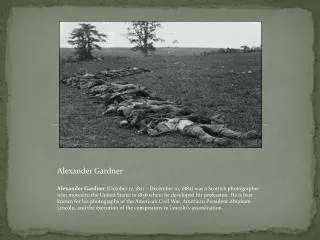
Photos by Alexander Gardner Courtesy of the Kansas State Historical Society. Sept. 1, 2010. These photographs, taken in and around Tonganoxie by Alexander Gardner in 1867, are presented courtesy of the Kansas State Historical Society.

E N D
Photos byAlexander GardnerCourtesy of the Kansas State Historical Society Sept. 1, 2010
These photographs, taken in and around Tonganoxie by Alexander Gardner in 1867, are presented courtesy of the Kansas State Historical Society.
Alexander Gardner’s wet-plate prep / developing mobile darkroom, Kansas 1867. Kansas Memory.org, Kansas State Historical Society, Copy and Reuse Restrictions Apply
A rare specimen found on hill above Fort Riley, Kansas. 420 miles west of St. Louis Mo. One side of a stereograph showing two unidentified men looking at a plant specimen near Fort Riley, Geary County, Kansas. The men are next to Alexander Gardner's photographic outfit. Kansas Memory.org, Kansas State Historical Society, Copy and Reuse Restrictions Apply
Depot Tonganoxie on branch road between Lawrence & Leavenworth, Kansas. 300 miles west of St. Louis Mo. One side of a stereograph showing the railroad depot at Tonganoxie, Leavenworth County, Kan. Visible in the photograph are people standing on the depot platform and stacks of wooden railroad ties.. Kansas Memory.org, Kansas State Historical Society, Copy and Reuse Restrictions Apply
Ox team at Tonganoxie, on branch road between Leavenworth and Lawrence, Kansas 1867 Kansas Memory.org, Kansas State Historical Society, Copy and Reuse Restrictions Apply
Tonganoxie, on branch road between Leavenworth and Lawrence, Kansas 1867 Kansas Memory.org, Kansas State Historical Society, Copy and Reuse Restrictions Apply
View at Tonganoxie, on branch road between Leavenworth and Lawrence, Kansas 1867 Kansas Memory.org, Kansas State Historical Society, Copy and Reuse Restrictions Apply
Tonganoxie farn, on branch road between Leavenworth and Lawrence, Kansas 1867 Kansas Memory.org, Kansas State Historical Society, Copy and Reuse Restrictions Apply
View of prairie near Tonganoxie, on branch road between Leavenworth and Lawrence, Kansas 1867 Kansas Memory.org, Kansas State Historical Society, Copy and Reuse Restrictions Apply
House and well where Jim L:ane shot Capt. Jenkins, Lawrence, Kansas. 323 miles west of St. Louis, Mo. 1867. Kansas Memory.org, Kansas State Historical Society, Copy and Reuse Restrictions Apply
Moore's Summit, Kansas, on branch road between Leavenworth and Lawrence, Kansas 309 miles west of St. Louis Mo. 1867. Kansas Memory.org, Kansas State Historical Society, Copy and Reuse Restrictions Apply
View from Moore's Summit, Kansas, on branch road between Leavenworth and Lawrence, Kansas 309 miles west of St. Louis Mo. 1867. Kansas Memory.org, Kansas State Historical Society, Copy and Reuse Restrictions Apply
View of prairie from Moore's Summit, Kansas, on branch road between Leavenworth and Lawrence, Kansas 1867. Kansas Memory.org, Kansas State Historical Society, Copy and Reuse Restrictions Apply
Cattle yard at Moore's Summit, Kansas, on branch road between Leavenworth and Lawrence, Kansas 1867. Kansas Memory.org, Kansas State Historical Society, Copy and Reuse Restrictions Apply
View embracing 12 miles of prairie from Moore's Summit, on branch road between Lawrence & Leavenworth 1867 Kansas Memory.org, Kansas State Historical Society, Copy and Reuse Restrictions Apply
Leavenworth, Kansas. 309 miles west of St. Louis, Mo. 1867. Kansas Memory.org, Kansas StateHistorical Society, Copy and Reuse Restrictions Apply
View from Moore's Summit, on branch road between Lawrence & Leavenworth, Kansas 1867. Kansas Memory.org, Kansas State Historical Society, Copy and Reuse Restrictions Apply
View in Salt Creek Valley, near Leavenworth, Kansas. 309 miles west of St. Louis, Mo. 1867 Kansas Memory.org, Kansas State Historical Society, Copy and Reuse Restrictions Apply