Download
1 / 36
360 likes | 448 Views
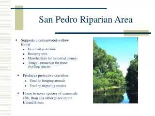
Understanding the Attributes and Processes that Constitute Riparian Function within Wetland (Lentic) Systems. San Pedro Riparian National Conservation Area St. David Cienega October 18, 2011 Mark Gonzalez National Riparian Service Team. Outline: Function of Lentic Systems.

E N D
Understanding the Attributes and Processes that Constitute Riparian Function within Wetland (Lentic) Systems San Pedro Riparian National Conservation Area St. David Cienega October 18, 2011 Mark Gonzalez National Riparian Service Team
Outline: Function of Lentic Systems • What is a Lentic System • Hydrogeomorphology • Vegetation • Soils • Water Quality • Potential and Capability; Sustainability and Trend
Lentic Systems • Lentus (Latin) means sluggish • Contrast “lotus,” past participle from “lavere,” meaning to wash; used for moving water systems • Lentic denotes “still” water systems • Lakes, ponds, sloughs, wet meadows, bogs, fens, marshes, swamps, vernal pools, springs, and cienegas Evanson allotment, Sheyenne National Grassland, ND
Hydrogeomorphology Perched systems: surface-water source Restrictive layer Saturated zone Direction of water movement Restrictive layer: (e.g., clay, silt) Bedrock or basin fill
Hydrogeomorphology Perched systems: surface and ground water sources Impermeable layer Saturated zone Direction of water movement Unsaturated zone Bedrock or basin fill Impermeable layer
Hydrogeomorphology Groundwater discharge systems (groundwater dependent ecosystems) Water table Water table Direction of water movement
Hydrogeomorphology Groundwater pumping: Surface and Ground water connected • Cone of depression • Recharge rate vs. extraction rate GW well Water table Direction of water movement Water table GW well
Hydrogeomorphology Disconnected ground and surface waters Saturated zone Direction of water movement Bedrock or basin fill Unsaturated zone Impermeable layer GW well
Hydrogeomorphology • Frequency Inundation characteristics • Depth • Duration FAC-FACU FACW OBL (em) AQU Open Water
Hydrogeomorphology Fluctuations/Decline in Water Table • Net drop • Rate of decline • Seasonality • Survivorship • Establishment • Regeneration • Dormancy • Invasive species • Upland species • New fire regime Capillary fringe
Hydrogeomorphology Management Concerns • Altered Flow Patterns • Dewatering • Loss of riparian habitat West I allotment, Sheyenne National Grassland, ND East A allotment, Sheyenne National Grassland, ND
Hydrogeomorphology Management Concerns • Dewatering -- loss/contraction of riparian habitat Pinedale Field Office, BLM, Wyoming
Vegetation • Shade the ground • Trap sediment Insert photo herbaceous shading in lentic area
Vegetation • Protect shorelines • Rooting strength Allotment 1-4, Little Missouri Nat. Grassland, ND Loss of riparian sponge due to lack of protective shoreline vegetation Little Missouri National Grassland, ND Williams allotment, Little Missouri National Grassland, ND
Vegetation: Drop in water table • Loss of riparian vegetation • Loss of vigor • Invasion by upland plants Whitetail Cr., Little Missouri National Grassland, ND Pinedale Field Office, BLM, Wyoming
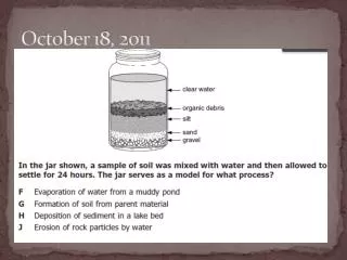
Soils Cobble- Gravel • The Sponge Silt Clay Sand Porosity = Hyd. Con. = 33% 2-20 m/day 33% 0.1-1 m/day 45%-60% 0.01-0.1 m/day 65%-90% 0.001 - 0.01 m/day Surface area (1g) = 0.01 m2, 5 m2, 150 m2
Soils • Depth to water Oi Oe NRCS, 2010 Winema NF, Oregon Army Corps of Engineers
Soils Evidence of saturation • Aerobic/anaerobic conditions • pH/nutrient availability Courtesy University of Idaho
Soils: Management Concerns • Alkalinity • pH Smith Allotment, Grand River National Grassland, SD
Soils: Management Concerns • Compaction • Pedestalling • Dewatering Carlson Slump, Idaho, by Steve Smith Pinedale Field Office, Wyoming Sloping Wetland, central Nevada, by M. Manning
Water Quality • Water Chemistry • Dissolved oxygen • Fecal coliform • Suspended sediment • Total sediment
Water Quality • Industrial waste • Point-source pollution • Waste-treatment plants • Nitrification
Decision Space NF FAR DFC PNC PFC ? Fisheries / Wildlife Time Recreation / Birding Watershed Values Livestock Values Values
Potential: greatest condition possible w/no constraintsCapability: best possible condition given political, social, and economic constraints (i.e., limiting factors) Direction of water movement Saturated zone Unsaturated zone Bedrock or basin fill Impermeable layer
Potential and Capability • Degree of Alteration? • Sustainable? • PFC = Sustainable Direction of water movement Saturated zone Unsaturated zone Bedrock or basin fill Impermeable layer
Potential and Capability • Degree of Alteration? • Sustainable? Direction of water movement Saturated zone Unsaturated zone Bedrock or basin fill Impermeable layer Former water surface
Potential and Capability • Does the change matter? How much change is too much? • E.g., Southwestern Willow Flycatcher habitat? Width Width
Potential and Capability • Does change matter? …For a Spike dace, speckled dace, or Gila chub?
Potential and Capability • Degree of Alteration? • Sustainable? Private lands SPRNCA (federal public lands) GW well Water table Direction of water movement Water table GW well Former water table
Potential and Capability • Degree of Alteration? • Sustainable? Private lands SPRNCA (federal public lands) Water table Water table Direction of water movement GW well Former water table
Potential and Capability What if incision was due to natural event? …Or human activity (e.g., artificial drainage)? Impermeable layer Direction of water movement Saturated zone Unsaturated zone Bedrock or basin fill Impermeable layer
Summary • Assessments of lentic systems based on: • Hydrogeomorphic attributes and processes; (Water sources, amount, depth, duration, frequency) • Vegetational attributes and processes; (Type, diversity, age distribution, root strength/stability, adaptation to saturation and anaerobic conditions) • Soil attributes and processes; (Saturation, water retention, chemistry)
Summary • Management Concerns • Alteration of hydrologic cycle • Alteration of water quantity • Surface and groundwater withdrawals • Minimum stream flows • Water rights • Vegetation vigor, type, and extent • Soil compaction, pedestalling, and dewatering
Summary • Potential and Capability • Potential is best possible condition • Proper functioning is minimum acceptable condition for long-term sustainability • Have current activities changed potential? • Do current activities affect sustainability?