Download

1 / 18
180 likes | 302 Views
The Oceanic Weather PDT is dedicated to improving aviation safety and efficiency in remote oceanic regions. Through the detection and forecasting of hazardous weather conditions, the workshop in Boulder, CO, focused on critical topics like cockpit display of weather products, volcanic ash detection, improved inflight winds, and turbulence forecasting. The collaboration with United Airlines and ARINC emphasizes timely delivery of crucial weather data to pilots. The initiative aims to enhance situational awareness and provide vital information about volcanic ash and severe weather, ensuring safer flights.

E N D
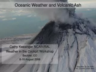
Oceanic Weather and Volcanic Ash Cathy Kessinger NCAR/RAL Weather in the Cockpit Workshop Boulder, CO 8-10 August 2006 Augustine, 12 Jan 2006 M.L.Coombs, USGS-AVO
Oceanic Weather PDT Primary mission: To improve aviation safety and efficiency within remote oceanic regions through the detection and forecasting of hazardous weather conditions. Oceanic Flight Information Regions • Long flight times of oceanic flights means pre-flight weather information becomes quite old • Weather into the cockpit is beneficial
Scientific Areas • Cockpit Display of Weather Products – Gary Blackburn • Volcanic Ash – Paul Herzegh • Improved Inflight Winds – Ted Tsui • Turbulence (CAT and CIT) – Bob Sharman • Convection Diagnosis and Nowcasting – Cathy Kessinger • Icing (FIP and CIP) – Marcia Politovich • Domains: • Pacific • North Pacific • Gulf of Mexico • North Atlantic - later
A little history… • NASA AvSP/AWRP Oceanic Convective Nowcasting Demonstration (OCND) Project • Purpose: demonstrate delivery of weather information in graphical form into the cockpit • ~1999-2001 • Workshops, user interactions and feedback to determine needs • AWRP Oceanic Weather PDT formed 2001 • OCND experience was basis
CTOP on Experimental ADDS Gulf of Mexico Pacific North Pacific • Experimental ADDS • Satellite page • http:weather.aero
Cockpit Display of CTOP • Collaboration with United Airlines and ARINC • Aircraft-relative display of cloud top altitude • Ascii format via thermal printer • ‘/’ = 30kft – 39kft and ‘C’ = >40kft • Pilot receives a “heads up” for approaching Wx. • Dispatcher also receives cockpit display • Common situational awareness • UAL testing on limited US-Aus flights • Favorable feedback, esp. unsolicited information Future Positions Cloud Top Height (CTOP) Current Position UAL 839
Web-based Pilot Feedback Form • Pilot feedback form…
OW Volcanic Ash Plans • Goal: Provide detection/warning/forecast capability of volcanic ash and gas plumes to aviation community • Requested by Users: • Five minute span from detectability to warning • Graphic of ash plume/cloud showing horizontal and vertical extent with frequent updates (inc. in the cockpit) • Current conditions & forecast (1 to 24h and beyond)
Volcanic Ash Advisory Center (VAAC) • Once eruption is reported (PIREP, Volcano Observatory, satellite), VAACs issue advisory to Met Watch Offices Meteorological Watch Offices issue VA SIGMET - AAWU, AWC, Guam, Hawaii - Dispatch, Airlines
Oceanic Weather Volcanic Ash Product • Build an expert system using: • Satellite remote detection – GOES, POES • A few NEXRADs near volcanoes • Seismic information • Dispersion models • Products: Detection and Forecast • Volcanic Ash Coordination Tool (VACT) is path to operations • AF PDT Development • Gives VAAC, AAWU, CWSU, Volcano Observatory common situational awareness to generate time-critical ash SIGMETS/forecasts • Anchorage first; Washington later
Getting a VA Product into the Cockpit… • After Advisory/SIGMET is ready for dissemination, then • Select specific aircraft that may intercept the ash cloud • Send graphical information directly to the aircraft via uplink • Human first, automation later • Within VACT • Do this within 5 minutes of receiving the advisory
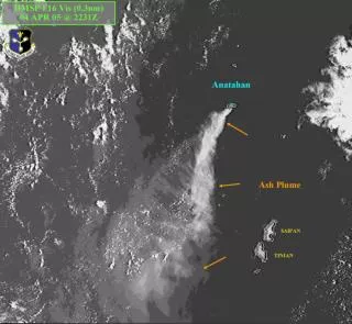
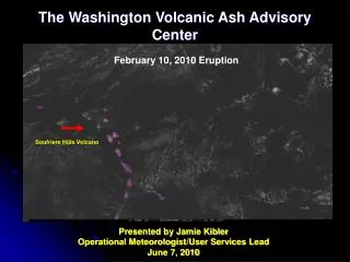
Soufriere Hills Eruption – 20 May 2006 • ~1100 eruption occurred • Stratospheric ash cloud • 1115 eruption cloud is visible on satellite • 1140 first Volcanic Ash Advisory (VAA) issued by Washington VAAC with few details • 1201 PIREP of ash to FL550, moving west • 1215 second VAA issued with details
Soufriere Hills Eruption, 20 May 2006, 1045-1445 Volcanic Ash Detection Visible Cloud Top Height Infrared
Washington VAAC Advisory Uplinked Product • Create graphical product to uplink to at-risk aircraft
Other Possible Uplinked Products for Oceanic Flights • Flight level winds from numerical model • Flight level temperature (fuel gel) from numerical model • Turbulence, both CAT and CIT sources • Hazardous convection and nowcasts • Icing