Download

1 / 26
260 likes | 412 Views
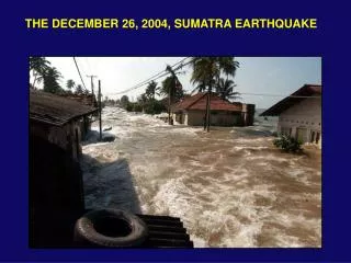
At 00:58:53 UTC on 26 December 2004 , Great earthquake off northeast coast of Sumatra, Indonesia. . Location map of Indonesia from the National Earthquake Information Center (http://neic.usgs.gov/neis/bulletin/neic_slav_l.html).

E N D
At 00:58:53 UTC on 26 December 2004, Great earthquake off northeast coast of Sumatra, Indonesia. Location map of Indonesia from the National Earthquake Information Center (http://neic.usgs.gov/neis/bulletin/neic_slav_l.html)
Earthquake caused by subduction of Indian plate beneath the Burma microplate Relative motion of Indian plate to Burma microplate = 0.06 m per year (2.4 inches per year) • Other tectonic elements in region: • Yangtze Plate • Eurasia Plate • Sunda Trench • Sunda Plate • Australian Plate • Ninety East Ridge Tectonic Setting of Earthquake of 26 December 2004 from United States Geological Survey (http://earthquake.usgs.gov/eqinthenews/2004/usslav/)
Mw = 9.0 Hypocenter = 30 km depth Focal mechanism = thrust Largest quake since 1964 Good Friday event, Alaska Large magnitude quakes at subduction zones are often tsunamigenic Local tsunamis propagate toward nearest shoreline Teletsunamis spread out across ocean basins Map showing epicenter (star) of earthquake from the National Earthquake Information Center (http://neic.usgs.gov/neis/bulletin/neic_slav_l.html)
Seismicity 1900-2004 Star is 26 Dec 2004 event Well-defined Benioff Zone associated with subduction of Indian plate beneath Burmas microplate Thus, main event occurred in seismically active area Many earthquakes annually Many have Mw > 6.5 (damaging magnitudes) Map showing historical seismicity (1900 - 2004) from the National Earthquake Information Center(http://neic.usgs.gov/neis/bulletin/neic_slav_l.html)
Est. rupture length = 1200 km Est. rupture width = 100 km Est. thrust fault offset = 15m Est. seafloor uplift = m? Uplift of seafloor is responsible for excitation of tsunamis Map showing historical seismicity (1900 - 2004) from the National Earthquake Information Center(http://neic.usgs.gov/neis/bulletin/neic_slav_l.html)
Areas potentially affected by tsunami inundation and run-up in yellow (i.e. shore zones < 20 m above sea-level) Areas Potentially Affected by Tsunami of 26 December 2004 from UNOSAT(www.unosat.org)
Areas potentially affected by tsunami inundation and run-up in red Map showing areas potentially inundated by tsunami on 26 December 2004 from UNOSAT.(http://cern.ch/unosat/freeproducts/Tsunami/JRC/Asia_Tsunami_07January_landcover.pdf)
Potential population affected by tsunami in red zone Potential population affected by tsunami on 26 December 2004 from UNOSAT(http://cern.ch/unosat/freeproducts/Tsunami/JRC/Asia_Tsunami_04January.pdf)
Predicted Arrival Time of First Tsunami Wave (in hours after earthquake)
Numerical simulation (computer model) of tsunami Dr. A. Piatanesi of the National Institute of Geophysics and Volcanology (INGV) in Rome, Italy.
Animation of Before and After Images of Banda Aceh, Indonesia Animation produced at the Earth Visualization Laboratory, University of Arkansas, USA By Dr. Stephen K. Boss
Countries Reporting Direct Casualties from Earthquake and Tsunami Indonesia Thailand Andaman Islands (India) Nicobar Islands (India) Myanmar Bangladesh India Sri Lanka The Maldives The Seychelles Kenya Somalia Tanzania In addition, many western nations are reporting fatalities and missing among tourists who were visiting the affected countries
Fundamental Features of Water Waves Wave Crest: is the highest portion of the wave. Wave Trough: is the lowest portion of the wave. Wavelength: is the linear distance separating wave crests (or separating wave troughs). Wave Amplitude: is the displacement of a crest or trough about the mean position or water level. Wave Height: is the total vertical distance from crest to trough (equal to twice the amplitude). Wave Period: is the time required for successive wave crests (or troughs) to pass a fixed point. from An Introduction to the World's Oceans, 8th edition by K.A. Sverdrup, A.C. Duxbury, and A.B. Duxbury (2004)
deep-water waves: water depth is greater than one-half the waves' length. shallow-water waves: depth becomes shallower than 1/20th of the wavelength Tsunamis have wavelengths ranging from 100 – 200 km! Tsunamis are, therefore, shallow-water waves (even in the open ocean)! Though tsunamis have very long wavelengths, their amplitude in the open ocean is often relatively small - commonly only a meter or two - and this amplitude is distributed over the very long wavelength so that tsunamis are quite imperceptible on the surface of the ocean. The speed of tsunamis is called celerity and is equal to: 3.31 x D0.5, where D = water depth (in meters) In the deep ocean, tsunamis travel at speeds up to 750 km per hour (465 mi/hr)!
Wave Refraction occurs when waves enter shallow water over an irregular bottom Wave traveling in shallowest water will also move with the slowest celerity Waves in deeper water continue moving with relatively greater celerity Wave crests will curve or refract as the wave moves forward
Waves spread or disperse upon passing through the gaps in barriers. This process is called "wave diffraction“ Barriers with many gaps scatter wave energy, diminish wave height and power
Numerical simulation (computer model) of tsunami Dr. A. Piatanesi of the National Institute of Geophysics and Volcanology (INGV) in Rome, Italy.
Tsunamis are waves generated by displacement of the ocean by impulsive events Events known to generate tsunamis: Submarine earthquakes Explosive volcanic eruptions Submarine landslides Terrestrial landslides that enter water bodies Impacts of large extraterrestrial objects (e.g. asteroids or comets) in the ocean
Tsunami Triggered bySubmarine Earthquake (other than 26 December 2004) The Great Chilean Earthquake and Tsunami, 1960 (largest earthquake ever recorded, Mw = 9.5) Tsunamis devastated Pacific Rim (Chile, Hawaii, Japan) Good Friday Earthquake, Anchorage, Alaska, 1964 (also an Mw = 9.2 earthquake) Tsunamis devastated coastal Alaskan communities Tsunami also devastated Crescent City, California
Tsunami Triggered byExplosive Volcanic Eruption Krakatau, Indonesia, 1883 On 26-27 August 1883, Krakatau volcano erupted Among most violent volcanic eruptions in last 200 years Tsunamis triggered by volcanic explosion and caldera collapse Destroyed 165 coastal Indonesian villages on Java and Sumatra 36,000 Fatalities Prior to 26 December 2004, most destructive tsunamis on record
Tsunami Triggered bySubmarine Landslides Storrega, Norway Series of submarine slides at ca. 35,000 and ca. 7,000 years ago Triggered by earthquake or decomposition of gas hydrate in seafloor sediment Storegga 1 (30,000-35,000 years before present) Storegga 2(approximately 7,000 years before present) Storegga 3(approximately 7,000 years before present) Largest mass movement affecting the northwest European continental margin in the last 50,000 years Tsunami deposited sediment widespread on Scottish coast
Tsunami Triggered by Terrestrial Landslide that Entered Water Body Lituya Bay, Alaska 9 July 1958 Large earthquake created massive rock avalanche into fjord in southeast Alaska Resulting impulsive wave is the highest ever recorded = 525 m (over 1,700 ft) Several eyewitnesses lived to tell about it!
Tsunami Triggered by Impacts of Large Extraterrestrial Objects Chicxulub, Mexico Asteroid impact site and tsunami trigger terminating the Cretaceous Period Asteroid believed to have had 10 km diameter (6.2 miles) Impact in shallow tropical seas Tsunami deposits widespread across Caribbean basin & Gulf of Mexico Impact event also associated with mass extinction of terrestrial and marine biota
Individuals interested in contributing to tsunami relief efforts are encouraged to contact reputable humanitarian agencies. The Andaman-Nicobar Earthquake and Tsunamis are possibly the greatest natural disasters in human history. At this time, worldwide relief efforts are underway as all nations attempt to provide comfort and aid to tsunami and earthquake survivors while also accounting for those who forever washed away. Individuals interested in contributing to tsunami relief efforts are encouraged to contact reputable humanitarian agencies.