EPO: Impact on US Weather Patterns
Learn about the East Pacific Oscillation index and its influence on US weather patterns, with insights into its correlation with other factors like NOI and its implications for upcoming winters.

EPO: Impact on US Weather Patterns
E N D
Presentation Transcript
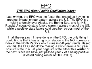
EPO THE EPO (East Pacific Oscillation index)Last winter, the EPO was the factor that ended up having its greatest impact on our pattern across the US. The EPO is a height anomaly over Alaska, the Bering Sea, and far NE Russia. A negative state favors warmth across most of the US, while a positive state favors cold weather across most of the US. In all the research I have done on the EPO, the only thing I could find is that it has a high correlation to the NOI (pressure index in the North Pacific) which runs in 6-8 year trends. Based on this, the EPO should be making a switch from a 6-8 year positive state to a 6-8 year negative state either this winter or the next, since we have just passed year 7 of it being positive. (Posted during winter of 2006-2007)
EPO • - EPO favors warmth over the U.S. • + EPO favors cold over the U.S. • During El Nino the effects of the EPO are minimal at best. • 2006-2007 outlook: Possible switch from 6-8 year positive state to 6-8 year negative state. EPO a non factor according to most UNLIKE 2005-2006 when it dictated our winter pattern.
EPO and AO • “However as long as the eastern Pacific Oscillation stays positive, and the artic oscillation does also, there is very little change for long term sustainable cold.” (JB in Jan 2007)
EPO and QBO This is a repeat in some ways of what went on last winter. I am sure I don't have to remind you that the consensus forecast from a lot of well-known private forecast services was for a cold and stormy winter 2005-06 over the eastern US. There is very low emphasis outside of my self from any other forecaster that I know about the power of the Pacific Jet last winter enhanced by a persistently positive EPO and the very negative QBO. IMO this is why most of the winter forecasts for a cold and /or stormy eastern US busted so badly in 2005-2006. DT (November 2006)
Vortex, EPO, and Pacific Jet (Jan 2007) As a result of this vortex over the North Pacific in the 2nd half of December, we have seen a very strong Pacific Jet flooding the US with warm air and record departures. -SSC-