Download
1 / 29
290 likes | 419 Views
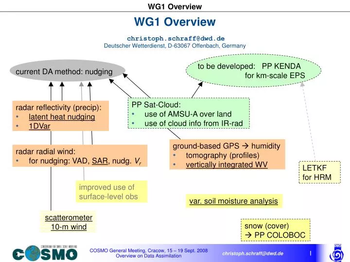
current DA method: nudging. WG1 Overview christoph.schraff@dwd.de Deutscher Wetterdienst, D-63067 Offenbach, Germany. to be developed: PP KENDA for km-scale EPS. PP Sat-Cloud: use of AMSU-A over land use of cloud info from IR-rad. radar reflectivity (precip): latent heat nudging 1DVar.

E N D
current DA method: nudging WG1 Overviewchristoph.schraff@dwd.deDeutscher Wetterdienst, D-63067 Offenbach, Germany to be developed: PP KENDA for km-scale EPS PP Sat-Cloud: • use of AMSU-A over land • use of cloud info from IR-rad radar reflectivity (precip): • latent heat nudging • 1DVar ground-based GPS humidity • tomography (profiles) • vertically integrated WV radar radial wind: • for nudging: VAD, SAR, nudg. Vr LETKF for HRM improved use of surface-level obs var. soil moisture analysis scatterometer 10-m wind snow (cover) PP COLOBOC
Use of Radar-derived Surface Precipitation:Latent Heat NudgingKlaus Stephan (DWD), Daniel Leuenberger (MetCH) • MetCH: LHN introduced operationally 20 June 2008, extensive verification done Talk: On the Value of Radar-Derived Rainfall Assimilation on High-Resolution QPF • DWD: Done: – microphysics change (2006) reduced evaporation below cloud base ratio RRsurf / RRupper-air and hence RRsurf / RRref increased (need to) revise definition of reference precipitation reduced overestimation of precipitation during LHN very small impact on forecasts • bright band detection inside COSMO model Outlook: – extend use of radar data to foreign radars • revise reference precipitation to account for (min.) radar beam height • better understand how (nature/) model develops convection (role of environment, (moisture) balance, …)
Bright Band detection (inside COSMO model) H_zero: height of freezing level in the model H_radar: height of radar beam RR_RAD: hourly sum of precip. observed by radar H_zero Ḣ_radar Bright Band criteria: • H_zero – H_radar [-300;600] RR_RAD(i,j) 2. > 8.5 <RR_RAD> Quelle: wikipedia
Synop-Regnie Radar g.pts. with BB (≥1x/day) ASS, LHN, no BB detect. ASS with BB detection ASS without LHN
Model space Background xb=(Tb, qb, psb) Initialization x=xb no MINIMIZATION x=(T, q, ps) yes Analysis xa=x Observation space Use of Radar-derived Surface PrecipitationVirginia Poli (ARPA-SMR) • ARPA-SMR: 1DVAR to retrieve T, q –profiles from RR (using linearised parameterisations of large-scale condensation and convection) then nudge T, q –profiles Poster: Assimilation of radar derived surface rain rate into the regional COSMO model through a 1D-Var+nudging scheme: analysis of results
Control run – Forecast +1 hour Experimental run – Forecast +1 hour Control run – Forecast +6 hours Experimental run – Forecast +6 hours Example of RR assimilation Very encouraging results! Assimilation of RR is able to dry off precipitation and also to create structures in the right place Shades: Radar observation Contours: COSMO-I2 forecasted RR
Simple Adjoint Retrieval (SAR) of 3-D Wind VectorJerzy Achimowicz (IMGW) (W.P.1.1.2) • input data: 3 consecutive scans of 3-d reflectivity and radial velocity at 10’-intervals, interpolated to Cartesian grid (1km x 1km x 500m , 20 levels) ‘predicted’ by • SAR method: very sensitive to errors in radial velocity input data new software package developed for QC of radar Doppler data (incl. de-aliasing, interpolation from polar to cartesian coord.) wind retrieval Doppler radial velocity
IWV gps < IWV mod qmodel ‘quality weights’ for ( ~ 1 betw. 700 – 800 hPa) : q gps Experiment • IWV from 169 Sta. every 15 min. (verify well with RS92-humidity, except for 12-UTC dry bias of RS92 in summer) • GPS assimilated like radiosonde humidity profiles, but with smaller horizontal influence ( ~120 km → ~ 50 km) • 1 – 13 June 2007, anticyclonic air-mass convection • 21-h forecasts from 0, 6, 12, 18 UTC ass cycle • comparison: ‘CNT’ : like opr (with RS + LHN) ‘GPS’ : CNT + GPS ‘noRSq : CNT – RS-humidity Use of Integrated Water Vapour (IWV) from Ground-Based GPSMariella Tomassini, Klaus Stephan, Christoph Schraff (DWD) (W.P. 1.2) IWV derived from observed TZD (with p, T from Synop or COSMO) pseudo-obs profile of specific humidity
Analysis 00 UTC 06 UTC 12 UTC 18 UTC Obs GPS 12 CNT 12 CNT 00 GPS 00 daily cycle of: IWV NoRSq CNT COSMO-DE too moist 12-UTC RS dries GPS GPS dries except at 12-UTC
CNT GPS NoRSq RS verification : BIAS (model - obs) 00-UTC runs 12-UTC runs + 0 h + 0 h + 6 h + 6 h
Synop verification 00 UTC Forecast 06 UTC Forecast 12 UTC Forecast 18 UTC Forecast Correct Cloud Cover Percent : GPS oooo CNT ****
Obs CNT GPS NoRSq + + + + + hourly mean of precipitation (forecasts compared to radar) 0.1 mm/h 0.1 mm/h increase of precip without RS-q reduction of precip by GPS 12 UTC runs 00 UTC runs 2.0 mm/h 2.0 mm/h
CNT GPS NoRSq + + + + + radar verification –ETS 0.1 mm/h 0.1 mm/h great improvement by GPS 00 UTC runs 12 UTC runs 1.0 mm/h 1.0 mm/h GPS: worse because too little strong precip in early evening
GPS – IWV : Conclusions & Outlook • GPS IWV obs from GFZ have good quality further comparison / assimilation with GPS data from ~ 1000 European stations (Eumetnet Project E-GVAP) main objects: data selection, extrapolation to 10 m, vertical + horizontal structure functions • GPS data have shown 12-UTC dry bias of RS92 (in 2007) validate new version of RS92 • GPS data useful for verification of daily cycle of humidity in the model test future development in data assimilation / physics with these data • GPS IWV assimilation reduces overestimation of precip at night and has significant positive impact in first 8 hours of 0-UTC forecasts, but tends to suppress strong precip in afternoon test again, when model physics improve daily cycle of precip, and test in winter
too strong gradient too low Assimilation of Scatterometer 10-m WindHeinz-Werner Bitzer (MetBW), Alexander Cress, Christoph Schraff (DWD) (W.P. 1.5) Experiment 28 Feb – 9 March 2008 , with QuickScat & ASCAT data no scatt with ASCAT / QuickScat COSMO-EU 9-h forecasts, valid for 6 March 2008, 9 UTC (10-m wind nudging with surface pressure correction which is in geostrophic balance with 10-m ana. incr.) pmsl (model – obs)
Soil Moisture InitialisationMartin Lange, Werner Wergen (DWD) (W.P.1.8.1) • aim: replace additional model runs by parameterized regressions to the determine the gradient of the cost function in the variational scheme (absolutely required for GME (long term dry drift), welcome for COSMO model) Cost function penalizes deviations from observations and initial soil moisture content Analysed soil moisture depends on T2m forecast error and sensitivity T2m/w current scheme: by additional model runs with slightly different w(k,0:00) new scheme: parameterised as a function of predicted latent heat flux at noon
Deutscher Wetterdienst Deutscher Wetterdienst Deutscher Wetterdienst comparison of parameterised SMA with operational SMA: experiment May – November 2006 BiasT2m on LM1 domain, avg 12:00, 15:00 RMSET2m on LM1 domain, avg 12:00, 15:00 no SMA opr. SMA param. SMA no SMA opr. SMA param. SMA T2m(12 & 15 UTC) :good performance in summer , degredation in winter
opr. SMA : top layer param. SMA: top layer opr. SMA : bottom layer param. SMA: bottom layer opr. SMA param. SMA Deutscher Wetterdienst Deutscher Wetterdienst Deutscher Wetterdienst comparison of parameterised SMA with operational SMA: experiment May – November 2006 RMS of SMA increments, at layer 4 (9-27cm) ( SMA incr. at layer 5 = 3 * (SMA incr. at layer 4) ) soil moisture content Small change in top layers, higher wetness in bottom layers • small differences in upper layers (until Nov.) • stronger moistening of lower layers (further reduces positive T2m bias in summer) parameterised SMA : almost zero increments during winter, starting mid September
sensitivity of T2m to w2 is different in operational and parameterised SMA in winter total differential: parameterised (in winter: near zero due to inactive plants) not parameterised, but how does it look like in the model (i.e. in the operational SMA)
soil water content: Lindenberg observations 15 Oct 2006 – 1 Jan 2007 (2.5 months) 5 – 7 Nov 2006 (2 days) 8 cm 15 cm 15 cm: reacts after 6 hours 30 cm: reacts after 4 days 45 cm: reacts after 2 weeks 60 cm 90 cm → expect model layer 27 – 81 cm to take about 1 week to react → expect model layer 9 – 27 cm to take few hours at most to react
soil water content: model at Lindenberg model layer 9 – 27 cm expected to take few hours at most to react → ok model layer 27 – 81 cm expected to take about 1 week to react → ok → gravitational drainage (sedimentation) appears roughly realistic in COSMO → soil moisture increments of operational SMA appear reasonable
Outlook parameterise also can be derived analytically from Richards eq. used in COSMO (TERRA) parameterisation already exists in current version of param. SMA parameterised SMA for GME: full experiment started, operational in spring 2009 parameterised SMA for COSMO: operational in 2009 (spring (?): simple version, autumn: with gravitational drainage) cheap, efficient Note: SMA parameterisation needs some maintenance to account for future changes in the parameterisation of surface fluxes e.g. modification of root water uptake include RH2m as additional obs (param. implemented, increments reasonable in first case) possible further extensions: • Analyse the top 5 soil layers separately instead of 2 aggregated layers (DWD). • Inclusion of precipitation analysis when good product is available (Suisse). • Improvement of model error statistics (Italy).
~ 1 by 1 converter simple + portable applicable to WMO or non-WMO BUFR IT section SKY / archive any kind of BUFR bufr 2 wmo_bufr WMO BUFR bufr2netcdf standard WMO templates, i.e. unique descriptors + dimensions of elements + code tables unique BUFR format for each obs type NWP section NetCDF obs 3DVar NetCDF feedback verification COSMO model Under discussion at DWD can keep AOF as alternative data input as long as needed NetCDF 2 ODB ODB monitoring DWD switches to NetCDF on 17 Sept. 2008 thereafter, DWD will no longer support AOF interface DWD plans: envisaged set-up observation formats, pre- and post-processing Advantages of NetCDF: • widely used and portable • a variety of software exists to plot, analyse and evaluate the data.
Deutscher Wetterdienst New T2mdiagnostics affects the whole PBL through SMA Bias T2m, C-EU on LM1-domain, avg12:00, 15:00 Accumulated soil moisture increments both runs done with operational version of SMA Rmse T2m, C-EU on LM1-domain, avg12:00, 15:00 COSMO-EU 20070427 00:00 +15 hours 2250 m Dew point temperature Germany 10 m analysis operational new T2m diagnostics
FORECAST FORECAST ASS ASS LHN and prognostic precipitation shows impact of LHN refinements in 2005 / 06 (reference precip / LHN restricted to ‘cloudy layers’ / grid point search / limits) mean skill scores over 32 forecast (00 and 12 UTC) AUGUST 2006 threshold 0.1 mm/h FBI ETS Stephan, K., S. Klink, C. Schraff, 2008: Assimilation of radar-derived rain rates into the convective-scale model COSMO-DE at DWD. Q. J. R. Meteorol. Soc.,134, 1315 – 1326.
New PP: Km-scale Ensemble-based Data Assimilation (KENDA) Discussion with input from Chris Snyder 18 Sept 2007 on EnKF • no new obstacles seen for the EnKF • to get a system to evaluate, need 2 people (with good background) for 2 years • do EnKF first without radar data (quality control problems), gain experiences, detect bugs / flaws in the scheme, later include radar data
Assimilation of Scatterometer Wind 29 Feb 08, 0 UTC COSMO-EU ana , no scatt COSMO-EU ana with ASCAT/QuickScat 10-m wind [m/s] ASCAT 28 Feb 08, 21 UTC ± 1.5h ECMWF analysis 29 Feb 08 984 hPa max. 30 kn ~15 m/s
Model space Background xb=(Tb, qb, psb) Initialization x=xb no MINIMIZATION x=(T, q, ps) yes Analysis xa=x Observation space Convert observations (Rain Rates - RR) in profiles of temperature and humidity and nudge them as “pseudo”-observations. Variational assimilation