Download
1 / 25
250 likes | 394 Views
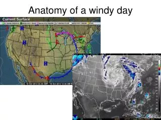
Anatomy of a windy day. What keeps a cyclone or anticyclone going? Jet Streams. Global Rivers of Air. Winds. Know affected by friction Friction is negligible a few kilometers above the surface of the earth. Allows for very high speed winds Faster winds = greater Coriolis effect

E N D
What keeps a cyclone or anticyclone going? Jet Streams Global Rivers of Air
Winds • Know affected by friction • Friction is negligible a few kilometers above the surface of the earth. • Allows for very high speed winds • Faster winds = greater Coriolis effect • Greater Coriolis effect = winds blow PARALLEL to isobars. • Called jet streams.
Jet stream characteristics • Defined: Fast moving river of air. • Few hundred KM wide, few KM thick • 120-140 km/hr • Found at the tropopause (10-15 km) • From West to East • Responsible for the convergence or divergence, at the tropopause, necessary to maintain cyclones and anticyclones
Two major jet streams: • In the North, polar jet is most important. • Marks the boundary between cold polar air in the North and warmer air in the South • Sets up a frontal zone! • In the South = subtropical jet • Both repeat in the Southern hemisphere to make a global total of four.
Severe Weather Thunderstorms & Tornadoes
Thunderstorm • Rainstorm that generates lightning and thunder! • Can also produce high winds • Hail • Heavy rain • Occasionally tornadoes • Form when warm, humid air rises in an unstable environment. • Means it will rise, and quickly!
Recall. . . • When air rises, it cools. • When air cools, its capacity decreases. • When capacity is decreased enough, the air becomes saturated. (Dew point) • Further cooling results in condensation (makes a cloud).
Where do they come from? • Beginning or Cumulus Stage • Unstable air means it will rise easily and quickly. (Low pressure) • Unstable air masses are different from their surroundings and will move vertically until they are in surroundings that are similar to them. • Stable air masses are similar to their surroundings and resist vertical movement. • Raising warm, moist air quickly will result in a cloud. • As air converges at the surface, water condenses, and latent heat is released(keeps air warm and rising) • This makes the cloud will become taller. (one hour)
Then what happens? • Mature stage • Water in the cloud becomes too much for the updraft to keep up. • Updraft = Hot air rises • It begins to rain! • Downdrafts form as air cools inside the cloud (cold air sinks) • Not that easy. . . • Stronger updrafts (severe thunderstorms) can freeze the water in the cloud(freezing warms atm). • Can also catch water (liquid/solid) as it falls and take it back upwards again. (cell) • This is very BAD for us if it is solid! HAIL!
Dissipating Stage • Water begins to cool inside the thunderhead. • Causes downdrafts to dominate the updrafts. • As the downdrafts dominate, the storm cell dies out. • Downdrafts are cutting off the “fuel” supply of warm, moist air from the updraft.
Severe Thunderstorms • As a storm front moves, new cells may fire along it as long as there is a supply of warm moist air. (Cloud/storm doesn’t move.) • Severe storms form in areas with strong vertical wind shear. (Air moving fast in opposite directions, up and down.) • Has a tilt in the updrafts and downdrafts • Allows them to be maintained for longer period of time. • High wind speeds, hail 2” or larger • May even cause rotation. . .
Tornadoes • Associated with severe thunderstorms • A spinning vortex, column of air, extending downward from the thunderhead. • Called a funnel cloud when it does NOT reach the ground. • Majority rotate counterclockwise
Tornado Formation • We don’t know everything! • Tend to happen when upper winds are blowing at a faster speed than surface winds. • Mesocyclone • Winds roll horizontally • Updraft of severe storms stand it upright.
Mesocyclone Radar signature