Download

1 / 65
750 likes | 1.37k Views
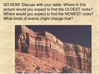
Can you find 7 Hearts in this picture here?. Next Geog Elect Class on Thursday. Bring protractor Bring calculator Bring string. Map Reading & Basic Techniques !. Read and interpret topographical maps. Mt Merapi.

E N D
Next Geog Elect Class on Thursday • Bring protractor • Bring calculator • Bring string
Map Reading & Basic Techniques! Read and interpret topographical maps
Mt Merapi • Mt Merapi is an active volcano in Indonesia that has erupted many times in the past. In 2006, it erupted again, affecting the lives of the thousands of people who live around it.
Satellite Image of Mount Merapi
Satellite Image of Mount Merapi
Large amounts of volcanic ash covered vehicles, making visibility very poor.
What other ways can we get more information about Mt Merapi’s height or geographical location?
Understanding our environment • Read and interpret physical and human features on topographical maps. • Basic techniques of interpreting and evaluating geographical data, which may be represented in various forms, such as graphs, photographs and satellite maps.
Topo Maps provide you with info such as height, distance, gradient...
Looking at the Environment through Maps Make sure you are familiar with the following components of map-reading Reading Topographical maps • Map Symbols (Legend) • Grid References • Compass Points • Scales (Large Scale/ Small Scale) 5. Reading Contour Lines
Map Symbols (Legend)
How do I find out where a particular landform is found on the map? How do I specify the location of a physical or human feature?
Northing and Easting 72 73 74 75 76 Northings are horizontal grid lines where their numbers increase from south to north. 85 84 83 Eastings are vertical grid lines that increase from west to east.
How do I determine the exact location of a place using northings and eastings? • 4 Figure Grid Reference • 6 Figure Grid Reference
To find the four figure grid reference, draw a “L” around the square
Always take the northing or easting with the smaller value! 29 28 42 41
North to South Grid Lines: Eastings East to West Grid Lines: Northings Reading Topographical mapsGrid References Four Figure Grid Reference: 1521
Six figure grid references • 180443 • 184441 • 181447 • 186448 • 188445
North to South Grid Lines: Eastings East to West Grid Lines: Northings Reading Topographical mapsGrid References Six Figure Grid Reference: 155217
Steps to deriving at the grid references • Locate the grid square where the feature is found. • Read the easting (vertical line) on the left of the grid square. • Read the northing (horizontal line) on the bottom of the grid square. • The four-figure grid reference consists of both the easting and the northing. To derive at the six-figure grid references, • Divide the grid square into ten equal parts along the easting and northing, and number them from 0 to 9. • Estimate how far the centre of the feature is from the easting and the northing, using the scale in tenths. • The six-figure grid reference consists of both the easting and the northing and an estimation of how far the feature is from the easting and the northing based on a scale of 0 to 10.
How to get to that place I want to go to on the map? Which direction should I go?
Reading Topographical mapsCompass Points N North Point
Cardinal Points 12 Intermediate Points • North East (NE) • North West (NW) • South East (SE) • South West (SW) • North-North-East (NNE) • East-North-East (ENE) • East-South-East (ESE) • South-South-East (SSE) • South-South-West (SSW) • West-South-West (WSW) • West-North-West (WNW) • North-North-West (NNW) North (N) South (S) East (E) West (W)
North NNE NNW NW NE ENE WNW West East WSW ESE SW SE SSE SSW South
Determining Directions • Bearings are compass directions, which are used to obtain the precise directions of one place or feature with another. • They are measured in degrees in a clockwise direction from the north.
How to Determine Directions using Bearings? • To measure the bearing of B from A, draw a straight line joining the two points. • Draw a line parallel to the Grid North through A. • Place the centre of the protractor over A, with the 0° on the protractor pointing to the North. • Read the bearing off the protractor where the line AB cuts the outer edge of the protractor. A 131° B N
Let’s Practice how to read bearings A A B C N N The bearing of C from A is 180° + 50° = 230° The bearing of B from A is 100°
What happens if I want to drive or take a bus to my destination? How do I find out what is the distance between the two points? So that I can estimate how much time I need to get there?
Measuring distances • Ruler • Pen • String • Piece of paper
Measuring distances • Scale: ratio of a distance on a map to the actual distance on the Earth’s surface.
Depending on the area of focus, you can choose to zoom on the area at various scales
Representing a Scale on a map • As a statement in words • For example, 1 centimetre represents 1 kilometre. • This means that 1 centimetre on a map represents 1 kilometre on the Earth’s surface. • Therefore, if the distance of a road measured on a map is 9 centimetres, the actual distance of the road is 9 kilometres.
Representing a Scale on a map 2) As a representative fraction (R.F.) • This is expressed as a ratio or fraction, for example, 1:25 000 or 1/ 25 000 may mean 1 milimetre represents 25 000 milimetres or 1 centimetre represents 25 000 centimetres and so on. • Distances can be easily calculated using the R.F. For example, if the distance of a HDB flat from a bus stop is 2 centimetres on a map (1 centimetre represents 25 000 centimetres), then the actual distance is = 2 X 25 000 centimetres = 50 000 centimetres or 0.5 kilometres
Representing a Scale on a map 3)As a line or linear scale • A linear scale consists of a line that is divided into units and sub-units such that measurements can be read off easily and accurately. • A linear scale can be easily converted into a scale using a statement or a R.F. • For example, in the diagram below, a distance of 1 kilometre on the linear scale measures 2 centimetres. This means that 2 centimetres represent 1 kilometres or 1 centimetre represents 0.5 kilometres. Metres 1000 0 1 Metres 1000 0 1 2 3 kilometres 2 3 kilometres A linear scale A linear scale
B) Reading Topographical maps 4)Scales (Large Scale/ Small Scale)
4)Scales (Large Scale/ Small Scale)


![Tell a Story! [Be the Batman]](https://cdn4.slideserve.com/7369331/slide1-dt.jpg)