Download
1 / 15
150 likes | 243 Views
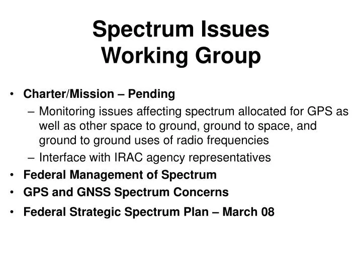
Spectrum Issues Working Group. Charter/Mission – Pending Monitoring issues affecting spectrum allocated for GPS as well as other space to ground, ground to space, and ground to ground uses of radio frequencies Interface with IRAC agency representatives Federal Management of Spectrum

E N D
Spectrum IssuesWorking Group • Charter/Mission – Pending • Monitoring issues affecting spectrum allocated for GPS as well as other space to ground, ground to space, and ground to ground uses of radio frequencies • Interface with IRAC agency representatives • Federal Management of Spectrum • GPS and GNSS Spectrum Concerns • Federal Strategic Spectrum Plan – March 08
COMMUNICATIONS ACT OF 1934 NTIA (On behalf of President) - National Defense - Law Enforcement & COORDINATION Security - Transportation - Resource Mgt Control - Emergencies - Other Services ADVISORY LIAISON INTERDEPARTMENT RADIO ADVISORY COMMITTEE (IRAC) 20 Govt Departments/Agencies as Members NTIA Chairs IRAC & Subcommittees CHECKS & BALANCES SPECTRUM MANAGEMENT SYSTEM FCC (Independent Agency) - Business - State & Local - Entertainment - Commercial - Private
GALILEO QZS GLONASS GPS Goal of Civil Interoperability Ideal interoperability provides users a PNT solution using signals from different GNSS systems • No additional receiver cost or complexity • No degradation in performance Interoperable = Better Together Than Separate
C/A C/A C/A C/A C/A C/A C/A C/A GPS M M M M M M M M M M M M M M M M M M M M M M M M P(Y) P(Y) P(Y) P(Y) P(Y) P(Y) P(Y) P(Y) P(Y) P(Y) P(Y) P(Y) P(Y) P(Y) P(Y) P(Y) P(Y) P(Y) P(Y) P(Y) P(Y) P(Y) P(Y) P(Y) Beidou/Compass ITU Filings Here ITU Filings Here ITU Filings Here ITU Filings Here L1 1575.42 MHz L5 1176.45 MHz E6 1278.75 MHz L2 1227.6 MHz GNSS Frequency Bands & Signals SBAS SBAS L2 1227.6 MHz L1 1575.42 MHz L5 1176.45 MHz GLONASS Possible future signal Possible future signal 1598.0625- 1605.375 MHz 1242.9375- 1248.625 MHz GALILEO E6 1278.75 MHz L1 1575.42 MHz E5a 1176.45 MHz E5b 1207.14 MHz QZSS L1 1575.42 MHz L5 1176.45 MHz LEX 1278.75 MHz L2 1227.6 MHz Beidou/Compass & IRNSS In S-band IRNSS
ICG Providers Forum Definition of Compatibility Compatibility refers to the ability of space-based positioning, navigation, and timing services to be used separately or together without interfering with each individual service or signal. • Radiofrequency compatibility should involve thorough consideration of detailed technical factors, including effects on receiver noise floor and cross-correlation between interfering and desired signals. The International Telecommunications Union (ITU) provides the framework for discussions on radiofrequency compatibility. • Compatibility should also involve spectral separation between each system’s authorized service signals and other systems’ signals. • Any additional solutions to improve compatibility are encouraged
Radio Frequency Compatibility • Ensures that signals do not unacceptably interfere with use of other signals • Requires thorough consideration of detailed technical factors, including • Effects on receiver noise floor • Crosscorrelation between interfering and desired signals • International Telecommunication Union (ITU) provides framework • Details are best worked bilaterally between providers
ICG Providers Forum Definition of Interoperability Interoperability refers to the ability of open global and regional satellite navigation and timing services to be used together to provide better capabilities at the user level than would be achieved by relying solely on one service or signal. • Ideal interoperability allows navigation with signals from at least four different systems with no additional receiver cost or complexity. • Common center frequencies are essential to interoperability, and commonality of other signal characteristics is desirable. • Multiple constellations broadcasting interoperable open signals will result in improved observed geometry, increasing end user accuracy everywhere and improving service availability in environments where satellite visibility is often obscured. • Geodetic reference frames and system time standards should also be considered. • Any additional solutions to improve interoperability are encouraged.
On-Line Spectrum Management Resources • NTIA Office of Spectrum Management Web Site • http://www.ntia.doc.gov • NTIA Manual of Regulations & Procedures for Federal Radio Frequency Management available for download in Adobe Acrobat Portable Document Format (PDF) http://www.ntia.doc.gov/osmhome/redbook/redbook.html Chapter 4. Allocations, Allotments and Plans Chapter 5. Spectrum Standards Chapter 10. Procedures for the Review of Telecommunication Systems for Frequency Availability and Electromagnetic Compatibility (EMC) • ITU Web Site • http://www.itu.int • Overview of the ITU Radio Regulationshttp://www.itu.int/sns/radreg.html • FCC Web Site • http://www.fcc.gov/ • FCC's Table of Frequency Allocations http://www.fcc.gov/oet/spectrum/table/fcctable.pdf
Main Benefit of Interoperability Geometry • More Satellites Better Geometry Improves: • Satellite coverage navigate where could not before • Dilution of Precision accuracy is better everywhere • Eliminates DOP holes (with open sky) • RAIM* integrity checked everywhere, all the time • Eliminates RAIM holes (with open sky) • Phase ambiguity resolution for survey and machine control applications * Receiver Autonomous Integrity Monitoring
Important for Interoperability Essential (cost driver) • Common Center Frequency • Like L5 & E5a • Same Antenna Polarization • Common Signal Spectrum • Identical receiver time delay with common spectrum • Same coherent integration period for acquisition • Usually related to symbol rate • Different symbol rates may require separate search correlators for acquiring signals Important (no time bias or filter issues) Desirable (ASIC gate count)
Other Interoperability Factors – System Time • System time offset may affect interoperability, depending on the circumstance • This is why system time offset parameters will be part of future GPS, Galileo, and QZSS messages • Permits use of only one or two extra satellites • Conversely, GPS and GLONASS receivers function well without a time offset message • Receivers compute and remember time offset, to high precision, if 2+3 or more satellites are in view • Time offset is a slowly changing solution variable • No impact with common differential corrections • From the same reference station or network