UNAVCO/GEON IT and Geophysical Research
UNAVCO/GEON IT and Geophysical Research. Data, Visualization, and Research in the Rocky Mountains Chuck Meertens and Greg Bensen UNAVCO, Boulder, Colorado www.unavco.org. UNAVCO Research contributions Acquisition, Formatting, and Delivery of Metadata, Data, and Derived Products

UNAVCO/GEON IT and Geophysical Research
E N D
Presentation Transcript
UNAVCO/GEONIT and Geophysical Research Data, Visualization, and Research in the Rocky Mountains Chuck Meertens and Greg Bensen UNAVCO, Boulder, Colorado www.unavco.org www.geongrid.org
UNAVCO Research contributions Acquisition, Formatting, and Delivery of Metadata, Data, and Derived Products Visualization of Geophysical Data and Models Rocky Mountains science research Collaboration with U. of Utah Yellowstone Database development Overview of Presentation www.geongrid.org
UNAVCO/GEON PoP Access to UNAVCO/GEON resources provided via the GEONgrid Portal www.geongrid.org
Geological Survey of Canada Chronos NASA Livermore USGS ESRI CUASI PoP node 5-node cluster 1TF cluster Partner services Partner Projects UNAVCO/GEON PoP • Provides Custom GEON Access to UNAVCO Resources • Data • Metadata • Software • Visualization • Geon research • Education and Outreach UNAVCOPOP www.geongrid.org
Data Access Methods Data Current Access Methods: http and ftp (e.g. GPS Seamless Archive, GSAC, webpages) OPeNDAP (e.g. IDV 3D Visualization) Under consideration: ODBC/JDBC SRB Arcxml Gridftp GML SCP Meta- Data UNAVCO/GEON PoP www.geongrid.org
GPS Seamless Archive (GSAC) • The GSAC helps you locate GPS data files which are archived at different GPS Data Archive Centers from a single user interface. • GSAC Clients: • The GSAC Wizard is a web-based client. • 2. The GSAC command-line client. • GSAC Retailer: • Gathers metadata and file locations from wholesalers • Organizes data into a POSTSQL relational database (same as GEON) • Provides services to GSAC Clients GEON “Instance” Of GSAC Retailer GSAC developed by Scripps and UNAVCO The GSAC will be the primary means of GPS raw data and data product discovery and access for EarthScope www.geongrid.org
UNAVCO/GEONOPeNDAP Server Unidata OPeNDAP software Unix binaries UNAVCO/GEON OPeNDAP Server - Seismic Tomography, Global Strain Rate, Geodynamic Models, Earthquakes -NetCDF format -GPSVel vectors -Free Form ASCII data Some OPeNDAP Server Software: -Free Form -netCDF -IDL -Matlab OPeNDAP data connector • Web browser • Data preview • Data download IDV Visualization Free form GPS vectors http://geon.unavco.org www.geongrid.org
Data VisualizationSame data or model => many uses …but currentlysame data + graduate students => fewer uses! www.geongrid.org
IDV VisualizationAn example of an end-to-end solution: data/models -> NetCDF -> OPeNDAP server -> Visualization & Collaboration (developed by UNIDATA using U. of Wisc. VISAD) www.geongrid.org
Data VisualizationExample: Mantle Tomography with IDV Example data on UNAVCO/GEON node and IDV xml configuration files simplify getting started with the IDV Metadata embedded in NetCDF file is returned from the OPenDAP Server in response to URI www.geongrid.org
IDV VisualizationMantle Geodynamics: Convection with geologic plate motions over 120 m.a. Purpose: "resolving multiple scale (both temporal and spatial) physics in mantle convection and lithospheric deformation" scale: "whole mantle with plates" resolution: "~40-50 -km, spherical geometry" method: "Numerical (finite element)" material_properties: "temperature and depth dependent viscosity (linear, no elasticity)" code: "CitcomS [Zhong, Zuber, Moresi and Gurnis, 2000], 5000 time steps, over 4 million nodes!" output: "normalized thermal and composition structure of the mantle from convection" credits: "McNamara and Zhong (2004) - Allen McNamara and Shijie Zhong" location: "Department of Physics at University of Colorado at Boulder, Campus box 390 Boulder Co, 80309-0390 USA" website: "http://anquetil.colorado.edu/szhong" Mantle Temperature www.geongrid.org
IDV VisualizationUNAVCO/GEON Enhancementsto UNIDATA’s Open source Java Code • UNAVCO is adding new features to UNIDAT’s IDV • (Dr. Stuart Wier, under contract to UNAVCO) • Earthquakes (done) • GPS vectors with error ellipses • Earthquake focal mechanisms • Customize for earth science (not atm) www.geongrid.org
Data Conversion Software • Java application to convert 1d and 3d gridded data to NetCDF format • Developed for UNAVCO/GEON by undergraduate student research assistant Andy Wahr (Purdue U.) • Command line interface • Forms • Documentation www.geongrid.org
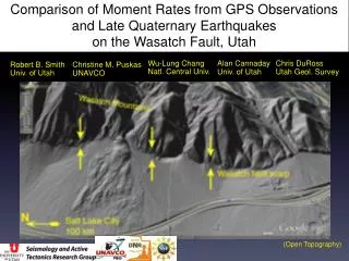
UNAVCO/GEON Rocky Mountain ResearchGRA Greg Bensen (UNAVCO, CU) with Prof. Anne Shehan (CU) and Prof. Randy Keller (UTEP) • Colorado seismology • Working with Rocky Mountain Front seismic data • Formatting database, locating local events (Colorado), calculating source mechanisms and stress drop. www.geongrid.org
Locations of local events will tell us about distribution of seismic hazards Source mechanisms (~200 new events) show magnitude and direction of the state of stress Will help to understand tectonics of the central Rocky Mountains Resulting data will be used to experiment with new visualization and serving techniques using GEON resources. Goals of Rocky Mountain Research www.geongrid.org
New Analysis of Earthquakes in the Rocky Mountain region Few Focal Mechanisms in existing Harvard CMT catalog…but earthquakes have occurred! Greg Bensen is using data collected in the Rocky Mountain Front Passcal seismic experiment to determine locations and focal mechanisms for ~200 new events recorded with IRIS PASSCAL instruments www.geongrid.org
Related Activities: Yellowstone The Yellowstone Volcanic System Database Bob Smith and Jamie Farrell, Univ. of Utah …See Poster! The purpose of the Yellowstone Volcanic System database is mainly two fold. The first is to integrate geographical, geological, and geophysical datasets into one large database. The second goal was to create an outlet for outreach and increased communication. Through this database web site, any researcher or lay person has access to the majority of Yellowstone related data at any time and virtually any place. www.geongrid.org
Yellowstone Tomography viewed with the IDV Shear wave topography of the Yellowstone plateau. The IDV allows the user to make cross-sections, probe the data, and to make 3-D isosurfaces of constant velocity anomaly. From M. Jordan and R. Smith, U. of Utah www.geongrid.org
The U. of Utah Yellowstone Volcanic System Database Examples Geography Boundaries States Yellowstone National Park Grand Tetons National Park Glacier National Park Roads States Yellowstone National Park Grand Tetons National Park Water Bodies Rivers States Yellowstone National Park Grand Tetons National Park Lakes States Yellowstone National Park Grand Tetons - wetlands Geology Idaho Montana Wyoming Yellowstone National Park Grand Teton National Park Geophysics Gravity States Greater Yellowstone Area Aeromagnetics Idaho Montana Wyoming Yellowstone National Park Earthquakes - Yellowstone Seismograph Stations in Greater Yellowstone GPS stations - University of Utah 2000 campaign www.geongrid.org
Yellowstone Volcano Observatory YVO is collaboration between the USGS, National Park Service and the University of Utah. Plans are to host the YVO data server on the U. of Utah GEON POP Sample from “Seisviewer” www.geongrid.org
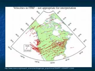
Harvard CMT solutions for Rocky Mountain region Very few focal mechanisms have been determined for the Rocky Mountain Region. www.geongrid.org