Download

1 / 2
20 likes | 118 Views
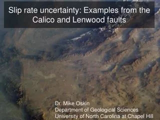
Attribute Illumination of Basement Faults Examples from Cuu Long Basin, Vietnam Ha T. Mai, Kurt J. Marfurt, University of Oklahoma, Norman, Oklahoma, USA. INTRODUCTION. DIRECTIONAL CURVATURE.

E N D
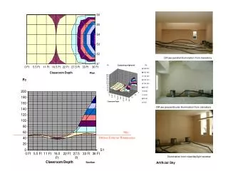
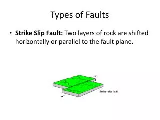
Attribute Illumination of Basement Faults Examples from Cuu Long Basin, Vietnam Ha T. Mai, Kurt J. Marfurt, University of Oklahoma, Norman, Oklahoma, USA INTRODUCTION DIRECTIONAL CURVATURE • Faults and fractures play an important role in forming effective fracture porosity for hydrocarbon traps in fractured basement reservoirs in many places, such as Venezuela, USA, Morocco, Brazil, Libya, Algeria, Russia ... and Vietnam. • Since this type of reservoir is very complicated, lack of stratified, coherent reflectors, illumination of basement faults/fractures is more problematic than illumination of faults within the sedimentary column. • In order to address these problems, it is important to carefully analyze different seismic attributes. • Seismic attribute is any measure of seismic data, related to target objects, such as time, velocity, amplitude, frequency, phase, energy … that helps us better visualize or quantify features of interpretation interest (which is faults/fractures surface in our case here). • Using proper set of seismic attributes can greatly help interpreters to delineate sweet spots, characterize fractured basement reservoirs, and better aid drilling. • In this research, we present several computation methods to enhance the signature of faults/fractures within basement zone, by taking seismic amplitude data, we generate the following seismic attributes: • Apparent dip • Amplitude gradients • Curvature • These seismic attribute volumes will then be rotated in different pre-defined directions, in order to better show the location or development of faults /fracture system in fractured basement. Curvature in 2-D is defined by the radius of a circle tangent to a curve. In 3-D, we need to fit two circles tangent to a surface. The circle with minimum radius is the maximum curvature (kmax) and the circle with maximum radius is the minimum curvature (kmin). Based on inline and crossline dip components, we calculate maximum, minimum curvature, and minimum curvature azimuth. From these three attributes volumes, we compute the apparent curvature of reflection surface for any pre-defined direction . Inline dip/grad cube Directional dip/grad cube Seismic cube AASPI processing package Crossline dip/grad cube =90 =120 =150 =30 =60 =0 DIRECTIONAL APPARENT DIP ANGLE AND AMPLITUDE GRADIENT • Dip angle is the angle of most coherence signal in a direction of analysis • Amplitude gradient is the lateral gradient of coherent amplitude along a direction of analysis • Take post-stack 3-D seismic data as input • Apply filter and smoothing methods to reduce noise and increase the coherency in the data. • Calculate dip angle and amplitude gradient for inline and crossline direction • Calculate dip angle and amplitude gradient for any defined direction. Curvature in two dimensions Curvature in three dimensions Max curvature cube Inline component Directional curvature cube Min curvature cube AASPI processing package Crossline component Chopra and Marfurt 2007 Min curvature azimuth cube METHODS APPLICATION SOFTWARE • A planar surface such as dipping horizon or faults can be presented by its true dip azimuth q and strike . The true dip can be presented by apparent dips x and y along the x and y axes • Having apparent dips at any two direction, we can reverse the calculation, and find true dip or apparent dip at any direction. • With that in mind, we expect to see planar or steeply dipping features more distinctly by viewing them perpendicular to their strike. • Base on this property, we choose to do directional analysis on three attributes: • Dip angle of reflection surface • Amplitude gradient • Curvature of reflection surface In order to demonstrate the mention methods, we will present some results from fractured basement of Cuu Long basin in Vietnam. Taking 3-D post-stack depth migrated seismic data from Cuu Long Basin as an input, using our AASPI Attribute Processing Software, we calculate directional attribute volumes, then present the results for directional dip angle, apparent amplitude gradient, and curvature at calculation directions of 0, 30, 60, 90, 120, 150 from North. Depth slices at 2750m is being shown. This is the depth right bellow basement surface. The results will show that different features will show up better in few analysis direction, and some other features will show up better in other analysis directions. Scanning though the different analysis directions, we can extract more information from seismic data. Attribute Volumes Seismic cube 3-D Seismic Volume AASPI Attribute Software http://geology.ou.edu/aaspi/ Seismic attributes such as structural dip, gradient, structure oriented filter, energy, curvatures, …
1000m 1000m 1000m 1000m 1000m 1000m 1000m 1000m 1000m 1000m 1000m 1000m =0 1000m 1000m 1000m 1000m 1000m 1000m 1000m 1000m 1000m 1000m 1000m 1000m Attribute Illumination of Basement Faults Examples from Cuu Long Basin, Vietnam Ha T. Mai, Kurt J. Marfurt, University of Oklahoma, Norman, Oklahoma, USA 2 1 2 1 2 =90 =60 =120 =30 =150 =0 =30 =150 =90 =60 =120 1 1 1 2 2 2 1 2 2 1 1 1 1 2 2 2 2 2 2 2 2 2 2 2 2 2 1 1 1 2 2 2 1 1 2 2 1 2 2 2 2 2 1 2 2 2 2 2 2 1 2 2 2 2 2 CONCLUSIONS A. DIRECTIONAL APPARENT DIP CUU LONG BASIN - INTRODUCTION 2 1 2 1 1 1 1 1 1 1 1 2 2 2 Several modern attributes, including volumetric computation of structural dip and azimuth, structural curvature, amplitude gradients, and amplitude curvature, are multi-component in nature and are thus amenable to visualization from different user-controlled perspectives. Precomputing every desired azimuthal view results in consumption of significant disk storage. However, through the use of ‘fast-batch’ spreadsheet-like attribute calculators available in several 3D interpretation software packages, such manipulation can now be put under user control. Eventually, we envision generating truly interactive azimuthal visualization software, thereby enabling the interpret to extract as much information from the data as possible. The structure of Pre-Cenozoic basement of the Cuu Long Basin is very complex, and is mainly composed of magmatic rocks. Under the influence of tectonic activity, the basement was broken into a suite of fault systems. This faulting provided favorable conditions for hydrocarbons from a laterally deeper Oligocene-Miocene formation to migrate and accumulate in the basement high. The basement is un-layered granitic rocks, such that the seismic signal appears to be very weak and noisy. We apply our workflow to enhance the faults signatures will aid our seismic interpretation, with the ultimate goal of estimating fracture location, density, and orientation We will focus on depth slice 2750m, which is right bellow top of basement, and examine the directional at 0, 30, 60, 90, 120, 150 from North. 2 1 1 1 2 2 2 2 2 1 1 1 1 =0 =30 =60 2 2 2 2 2 2 =0 =30 =60 1 1 2 2 1 2 2 2 1 1 2 1 2 2 2 1 1 1 1 1 1 1 1 1 1 1 1 2 2 1 1 1 =0 =90 =0 =90 1000m 1000m 1000m 1000m =90 =120 =150 1 1 2 =90 =120 =150 2 2 2 2 ACKNOWLEDGEMENTS 2 2 2 2 2 1 1 1 2 • We would like to thank PetroVietnam and Cuu Long JOC for providing seismic data, and allowing us to publish the results used in this report. • - The attribute seismic results are generated by a processing package developed by AASPI group at University of Oklahoma. • - The rotation of the images was achieved through the use Stanford’s SEPlib mathematic utility • The slice images are generated using of Schlumberger’s Petrel. • The Rose diagrams were generated using Dr. R. J. Holocombe’s GEOrient software. 2 1 1 1 B. DIRECTIONAL AMPLITUDE GRADIENT =0 =30 =60 REFERENCES • Barnes, A. E., 1996, Theory of two-dimensional complex seismic trace analysis: Geophysics, 61, 264-272. • Chopra, S., and K.J. Marfurt, 2007, Seismic attributes for prospect identification and reservoir characterization: Geophysical Developments 11, Society of Exploration Geophysicists. • Barnes, A. E., 2000, Weighted average seismic attributes: Geophysics, 65, 275–285. • Barnes, A. E., 2003, Shaded relief seismic attribute: Geophysics, 68, 1281–1285. • Denison, R. E., 1981, Basement rocks in Northeast Oklahoma: Oklahoma Geological Survey Circular 84. • Luza, K. V., and J.E. Lawson, 1983, Seismicity and tectonic relationships of the Nemaha Uplift in Oklahoma Part V. • Marfurt, K. J., 2006, Robust estimates of 3D reflector dip and azimuth: Geophysics, 71, 29-40. • Randen, T., E. Monsen, C. Signer, A. Abrahamsen, J. O. Hansen, T. Soeter, J. Schlaf, and L. Sonneland: 2000, Three-dimensional texture attributes for seismic data analysis, 70th International Meeting, SEG, Expanded Abstracts, 19, 668-671. • Roberts, A., 2001, Curvature attributes and their application to 3D interpreted horizons. First Break, 19, 85-99. • Singh, S. K., H. Abu_Habbiel, B. Khan, M. Akbar, A. Etchecopar, and B.Montaron, 2008, Mapping fracture corridors in naturally fractured reservoirs: an example from Middle East carbonates: First Break, 26, no. 5, 109-113. • Thorman, C. H., and M.H. Hibpshman, 1979, Status of mineral resource information for the Osage Indian Reservation, • Oklahoma :Administrative Report BIA-47, U.S. Geological Survey and Bureau of Mines. Dip Magnitude with basement top Seismic with basement top 1000m 1000m =90 =120 =150 C. DIRECTIONAL CURVATURE Most negative curvature Most positive curvature kmax kmin seismic Most negative curvature Inline Dip Inline amplitude gradient kmin azimuth Crossline Dip Variance Most positive curvature Crossline amplitude gradient