Download
1 / 32
320 likes | 341 Views
Learn how to use conditional statements in Python to extract specific bands from Landsat images based on folder names, and save them as GeoTIFF files.

E N D
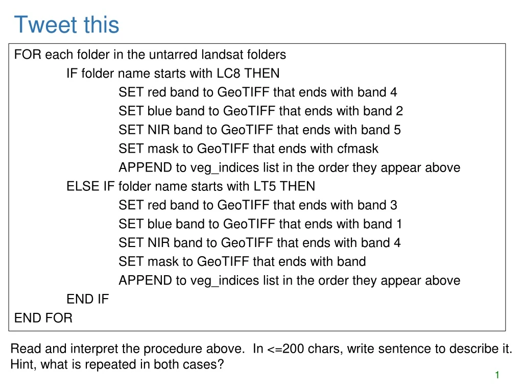
Tweet this FOR each folder in the untarred landsat folders IF folder name starts with LC8 THEN SET red band to GeoTIFF that ends with band 4 SET blue band to GeoTIFF that ends with band 2 SET NIR band to GeoTIFF that ends with band 5 SET mask to GeoTIFF that ends with cfmask APPEND to veg_indices list in the order they appear above ELSE IF folder name starts with LT5 THEN SET red band to GeoTIFF that ends with band 3 SET blue band to GeoTIFF that ends with band 1 SET NIR band to GeoTIFF that ends with band 4 SET mask to GeoTIFF that ends with band APPEND to veg_indices list in the order they appear above END IF END FOR Read and interpret the procedure above. In <=200 chars, write sentence to describe it. Hint, what is repeated in both cases?
Decision making & the Describe object Dr. Tateosian
Outline • Conditional statements • Decision-making syntax • Boolean Expressions • Logical operators • Comparison operators • Describing ArcGIS data
The anatomy of decision-making in Python • keywords if, elif, else • conditional statements • yawnCount > 5 • blocks of code • print 'I just had lunch' • print "I'm sleeping." • indentation –IDE helps • dedentation • colon • if yawnCount > 5:
Syntax for branching • if <conditional statement 1>: print ‘hi’ • elif <conditional statement 2>: print ‘ho’ • else: print ‘hey’ • if <conditional statement 1>: print ‘hi’ • else: print‘ho’ • if <conditional statement 1>: print ‘hi’ Pop quiz How many elifblocks of code can you have? How many elseblocks can go with eachifblock? Is the elseblock required? Which of these examples always print something? If conditional statement 1 is true will all of these examples print something? Give an example for conditional statements 1 and 2 so that ‘ho’ would never be printed? (answer for each box) • if <conditional statement 1>: • print ‘hi’ • elif<condition statement 2>: • print ‘ho’
Truth table review • The expression that goes behind the "if" or "elif" in Python is a Boolean expression (a statement which is true or false) • Examples: • yawnCount> 5 • It's raining • Today is Friday • It's raining and today is Friday • That last one is a compound statement using a logical operator "and" to join the two parts. • A familiarity with introductory logic is helpful in writing well formed conditional code.
Boolean Expression • Boolean expression: expression that is either true or false. • A conditional statements consist of Boolean expressions with logical and comparison operators. • 'False' in Python: • False • None • 0 • “” • () • [] • {} • All other numbers, strings, • lists, dictionaries, tuples • evaluate as True Logical operatorsand, or, and not Comparison operators >, <, <=,>= != not equal == equal
Comparison operators x > y # x is greater than y x < y # x is less than y x >= y # x is greater than or equal to y x <= y # x is less than or equal to y x != y # x is not equal to y x == y # x is equal to y Assignment (=) versus comparison (==) >>> x = 5 # assigment statement >>> y = x >>> y == x True >>> y = x + 1 >>> y == x # comparison statement False >>> print y 6 >>> print x 5
Logical Operators Gotchas 1 Logical operators: and, or, and not. • Statements must be complete on each side of operator. • Example: print when the species is salmon or tuna if species == 'salmon' or 'tuna': print species if species == 'salmon' or species == 'tuna':print species WRONG SOLUTION: true… so the entire statement is always true RIGHT SOLUTION:
Logical Operators Gotchas 2 • Beware of English language to logic statement conversions • Example: Print the species if it’s not a trout or catfish. • Test cases: cod, trout, and catfish ifspecies != 'trout' or 'catfish': printspecies if species != 'trout' or species != 'catfish': print species if species != 'trout' and species != 'catfish': print species DeMorgan’slaw: ~(p or q) ↔ ~p and ~q Solution? True all the time! If species is trout, the first statement is not true, but the 2nd one is. Solution? Solution?
Branching workflow example • kml preparation tool. Different for vector/raster/other datatypes. Different for points/lines/polygon. Different for TIFs and other formats. How can I determine what type of data I have? GET data type raster other feature class shapefile PRINT 'warning, knuckle head' GET format GET shape type point line polygon other TIF other CALL point to kml CALL polygon to kml CALL convert to TIFF CALL line to kml CALL layer to kml
Describe Object desc = arcpy.Describe(rastfile)
Creating a describe object >>> # Create geoprocessing objects>>> import arcpy >>> # Set the data element>>> rastfile = 'C:/Temp/raster1' >>> # Call describe method>>> dsc = arcpy.Describe(rastfile) >>> printdsc<geoprocessing describe data object object at 0x0092D2D0> object.method(arg1,arg2, …) describe object data element to be described
Using a describe object >>> import arcpy>>> rastfile = 'C:/Temp/raster1'>>> dsc = arcpy.Describe(rastfile) >>> print dsc.dataType'RasterDataset' >>> print dsc.format'IMAGINE image‘ See note view for demo
Selection Syntax • Convert the pseudocode to Python • Python conditional keywords: if, elif, else • Use a describe object to get the shapeType • Python • import arcpy • mydata = 'C:/Temp/data.shp' • dsc = arcpy.Describe(mydata) • shapeType = dsc.shapeType • if shapeType == ‘Polygon’: • print'Shape is polygon' • elif shapeType == ‘Polyline’: • print'Shape is line' • else: • print'Shape is not line or polygon' Pseudocode GET shapefile GET shape type IF shape type is polygon THEN PRINT shape is polygon ELSE IF shape type is line THEN PRINT shape is line ELSE PRINT shape isn’t line or polygonENDIF
Using describe with caution • More cautiously • import arcpy • mydata = 'C:/Temp/data.shp' • dsc = arcpy.Describe(mydata) • ifdsc.dataType == 'ShapeFile': • shapeType = dsc.ShapeType • if shapeType == ‘polygon’: • print'Shape is polygon' • elif shapeType == ‘line’: • print'Shape is line' • else: • print'Shape is not line \ • or polygon' • Previous slide • import arcpy • mydata = 'C:/Temp/data.shp' • dsc = arcpy.Describe(mydata) • shapeType = dsc.ShapeType • if shapeType == ‘polygon’: • print'Shape is polygon' • elif shapeType == ‘line’: • print'Shape is line' • else: • print'Shape is not \ • line or polygon'
Summing up • Topics discussed • Conditional statements • Decision-making syntax • Boolean Expressions • Logical operators • Comparison operators • Describing ArcGIS data • Coming up • Looping • Additional topics • Tools that make selections • Select by attributes • Compound vs. nested conditions • Testing conditions • Using os module to check for files
Condition with ‘not’ keyword conditional statement Pseudocode IF field name does not exist THEN CALL Add fieldENDIF CALCULATE FIELD Python code fileName = 'C:/data.shp' fieldName = 'slope' fields =['FID', 'rise', 'run'] iffieldNamenot in fields:arcpy.addField(fileName, fieldName) print 'New field created.' arcpy.CalculateField(fileName, fieldName, \ '[rise] / [run]‘) colon indent entireifcode block(code block = set of related code)
Buffer_clip… avoid argv index error • Check the list length before indexing it, give feedback, and exit if necessary • use try/except (discuss later) import sys listLength = len(sys.argv) # count the number of arguments iflistLength < 5: print'Usage: <shapefile to buffer>, <buffer distance>, <shapefile to \ clip>, <the workspace >' # explain the problem to the user sys.exit(0) # exit the program. # buffer_clip.py arguments fireDamage = sys.argv[1] park = sys.argv[2] bufferDist = sys.argv[3] arcpy.env.workspace = sys.argv[4] # Buffer and clip code below here…
Using if/elif/else • Use if alone when you only want do y if x is true, and you want to continue with the rest of the script in either case. • … • iffield_namenot in fields:arcpy.addField(filename, field_name) • # Update field values • Use elifto check another conditional statement. Follows if or elif block. • Use else to enact a default action. If none of the previous conditions are true, do what I say. Follows if or elif block. • ifshapeType == ‘polygon’: print'Shape is polygon' elifshapeType == ‘line’: print'Shape is line' else: print'Shape is not line or polygon'
Ways not to use if, elif Instead should be if x == 1: #do stuff if x == 2: #do special stuff if x == 3: #do very weird thing if x == 1: #do stuff with a elif x == 2: #do stuff with b elif x == 3: #do stuff with c elif x == 4: #do stuff with d elif x == 5: #do stuff with e elif x == 6: #do stuff with f … Don’t use repeated if to check mutually exclusive conditions. if x == 1: #do stuff elif x == 2 #do special stuff elif x == 3 #do very weird thing Don’t use a large number of ‘elif’ conditions when consistently testing the same variable’s value and performing the same operation inside. There are better ways to do this. Instead should be using Python built-in data structure called a dictionary. --Dictionaries will be discussed in a later lecture.
In class – Poor form! FIX IT • Point statistics 2. Currency conversion 3. Grader • IF average < 60 • NULL • ELSE • DO GivePassingGrade • ENDIF
FIX IT • Point statistics 2. Currency conversion 3. It is considered poor form to have a 1-sided IF stmt where the action is on the 'no' or ELSE side. This could (and should) be rewritten to eliminate the NULL 'yes' part. To do that, we change the < to its opposite: >= as follows : IF average >= 60 DO GivePassingGrade ENDIF
Polygon to raster • Purpose: If the given input is a polygon shapefile, perform polygon to raster conversion using the given field to assign raster values, otherwise inform the user that the conversion did not occur. • What will happen if the input file is… • a polygon shapefile? • convert the data to raster (success) • a point shapefile? • attempt to convert the data to raster, but will fail, since it’s not polygon input but it is a shapefile • a raster file? • attempt to check the geometry of the inputfile and fail, since raster files don’t have a geometry • When does it give a warning? • never
Polygon to raster pseudocode corrected • Instead of else if, use a compound conditional IF input file is a shapefile AND input file geometry is polygon THEN CALL convert polygon to raster using field to assign raster values. ELSE PRINT Warning: Conversion not performed. PRINT Input file data type Moral: TEST ALL CONDITIONS
Distance converter example • Convert miles to km or km to miles and handle user input of 2, 1, or 0 arguments: Arguments: 50 miles >>> 50 miles is equivalent to 80.0 kilometers. Arguments: 100 >>> Warning: No distance unit provided. Assuming input is in miles. 100.0 miles is equivalent to 160.0 kilometers. Arguments: >>> Usage: <numeric_distance> <distance_unit(miles or km)>
Distance Conversion Pseudocode GET numeric dist from args GET unit from args IF unit is miles THEN COMPUTE km PRINT results ELSE COMPUTE miles PRINT results ENDIF • Add to the pseudocode to handle case of 'no user arguments'. • Add pseudocode to part 1 to handle the '1 argument' case.
Distance conversion pseudocode Related code given in examples 9.12 and 9.13 in the book.
Buffer_clip pseudocode GET number of arguments IF number of args < 5 PRINT usage EXIT code ENDIF SET fire damage SET park SET buffer distance SET workspace GET number of arguments IF number of arguments < 4 PRINT usage EXIT code IF number of args is 4 PRINT warning SET workspace to default ELSE SET workspace to last arg ENDIF SET fire damage SET park SET buffer distance All or nothing. How could we make the last argument (the workspace) optional?