Enhancing NOAA’s Oil Spill Response with Server-Side Subsetting Using OPeNDAP Technology
This presentation discusses the integration of server-side operations for handling unstructured grid models in NOAA’s response to oil and chemical spills. It focuses on the necessity of efficient data subsetting techniques, highlighting NOAA's reliance on trajectory modeling tools like GNOME. Key advancements, such as improved interoperability between OPeNDAP and Unidata servers, aim to facilitate timely data access and support for incident responses. The role of various ocean models in addressing specific coastal hazards, such as the Deepwater Horizon spill and other critical case studies, is emphasized.

Enhancing NOAA’s Oil Spill Response with Server-Side Subsetting Using OPeNDAP Technology
E N D
Presentation Transcript
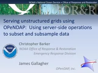
NOAA’s National Ocean Service • Office of Response and Restoration Serving unstructured grids using OPeNDAP: Using server-side operations to subset and subsample data Christopher Barker NOAA Office of Response & Restoration Emergency Response Division James Gallagher OPenDAP, inc.
NOAA Emergency Response Division • National Contingency Plan specifies NOAA’s role in supporting the Coast Guard: “Provide scientific expertise to support an incident response for Oil and Chemical Spills”
Key Role: Trajectory Modeling • Where is the oil (or chemical) going?
Primary Tool: GNOME(General NOAA Operational Modeling Environment) • Lagrangian element (particle) model • Forcing from external sources: • Winds • Currents • Currents: • In house model • External operational models
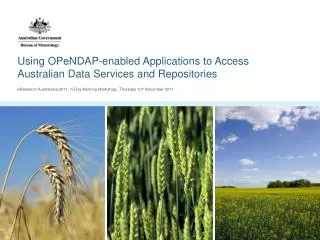
Example: Deepwater Horizon • Ocean models utilized: • NOAA CSDL: NGOM • Navy models: NCOM, HYCOM, IASNFS • USF: West Florida Shelf ROMS • TGLO/TAMU: TX shelf ROMS • NC State: SABGOM • All structured grid models
Unstructured Grid Models? • Unstructured Grids: • Allow resolution to vary spatially • Conform to boundaries • Nice for oil spills and particle tracking • Many more UGRID models coming online • Many papers at this conference
Some Models of Interest • FVCOM: • nGOMOFS (NOAA CSDL) • Gulf of Maine/Mass Bay (UMASS) • Salish Sea (PNNL) • SELFE: • Columbia River (OHSU) • Texas Estuaries models (UT) • ADCIRC: • Gulf of Mexico / Southern LA and Texas grid 9,108,128 nodes--18,061,765 elements
nGOMOFS (NOAA CSDL) V6 90,310 Nodes 174,550 Elements
What if I just need Mobile Bay? Mobile Bay, AL detail grid. About 300 m grid resolution along a 13 m deep navigation channel
FVCOM-GoM/GB for Mass Bay and Nantucket Sounds/Shoals Boston Inner Harbor
ADCIRC:Gulf of Mexico / Southern LA and Texas grid (SL18TX) • Gulf of Mexico / Southern LA and Texas grid 9,108,128 nodes--18,061,765 elements • Just surface currents: • 275 MB per time step (plus the grid specs)
Obstacles to using UGRID models: • No standard for data/results on UGRIDS: • Informal working group for (quite!) a few years • Recent draft standard (netcdf 3) • Work on JavaNetcdf lib to support it (SURA modeling test bed project) • Big Grids: • Need server side subsetting
How to get it done? • NOAA/ORR post-DWH funding: • Better able to response to large spills • We started talking to folks about server-side subsetting options • But we’re clients: • We’re not going to run a server • We needed something that would become an excepted standard/tool.
How to get it done? • NOAA/NESDIS noted assorted issues: • Netcdf/OpenDAP development funding limited • Multiple diverging implementations: “Unfunded Mandate” • NESDIS coordinated funding from: • Technology, Planning and Integration for Observations (TPIO) Program • OR&R • National Climatic Data Center (NCDC)
OPeNDAP-Unidata Linked Servers (OPULS) • NOAA/BAA grant supports this important collaboration between Unidata & OPeNDAP • First goal: conformance between OPeNDAP & Unidata servers, through which access is gained to growing amounts of NOAA & related data. Other short-term goals include: • Asynchronous modes, such as are needed for (delayed) access to near-line data, perhaps stored on tape, e.g. • Improved access (with server-side subsetting) to data organized on non-rectangular meshes, such as in coastal modeling • Work began in Boulder during October & will be influenced by an advisory committee (yet to be appointed)
OPeNDAP:the Data Access Protocol • DAP2 combines simple data model with a general set of operators. • Data Model: Atomic types (e.g., ‘Integer’); Arrays; Structures; Grids; and Sequences. • Operators: These provide ways to subset all but the atomic types. • Domain neutral: By keeping the semantics of the model clean, we ensure that it can be applied to many different types of data.
But how is it used? • DAP is generally used as a ‘web service’ • DAP requests are made using a URL • DAP responses are ‘documents’: • Text that contains metadata • Combination of text/metadata and binary data. • Applications read these responses and use them it whatever ways they see fit: • the netCDF client library makes legacy applications believe they are reading from a local file
About Array and Grid Selection • In addition to requesting a Grid or Array, the Selection can be used to subset in indicial space.
About Functions • Constraint Expression can contain functions • These functions can perform any operation that can be programmed. • Thus they provide a good way to extend a data server to perform new operations • These include operations that are not domain neutral • In Hyrax they are written in C++
Example URLs • The base URL: “http://test.opendap.org/opendap/data/nc/fnoc1.nc” • To get metadata: • Dataset variables: http://test.opendap.org/opendap/data/nc/fnoc1.nc.dds • … attributes: http://test.opendap.org/opendap/data/nc/fnoc1.nc.das • Or less readable in XML: http://test.opendap.org/opendap/data/nc/fnoc1.nc.ddx • To get data: • Just the variables u and v: http://test.opendap.org/opendap/data/nc/fnoc1.nc.dods?u,v • … in ASCII so it’s easy to read: http://…/opendap/data/nc/fnoc1.nc.asc?u,v • With subsetting: • http://test.opendap.org/opendap/data/nc/fnoc1.nc.asc?u[0][3:6][5:8] • Here’s a function: • http://…/nc/coads_climatology.nc.ascii?geogrid(SST,45,-80,20,-60,”1000<TIME<3000”) • This is an example of how functions can enable domain-specific behavior; this function will return an error if the Grid is not ‘geospatial’
Challenges • Unstructured Grids are not a specific type in DAP • We must choose a way, or set of ways, to represent these data • Datasets are often too large to download – subsetting must be done server-side. • Because the subsetting operations are complex, we will need to use server-side functions to implement them
Requirements • Must enable subsetting by polygonal regions • The result must be an unstructured grid itself • A subset must preserve the topological and geometric relationships present in the whole: • we can’t just regrid everything to a more convenient form.
Proposed Solution • Server-side function to add subsetting • Adopt the proposed unstructured grid encoding using netCDF3 • Result of the function will be a DAP2 response • Input is netCDF3 with some additional ‘conventions’: it can be represented in DAP2 • There are existing clients that can read DAP2 • If they understand netcdf in the new convention, they will understand the results
The server-side function • Ugrid(Mesh,<polygon>) • <polygon> is a comma separated list of latitude and longitude points • However, there is an arbitrary limit to the number of characters in a URL, so • We will also support POST when OPULS makes the transition to DAP4 • It will likely take more than a year for all of DAP4 to be realized, but POST for constraint expressions will be set in the first year.
Example ugrid() calls • http://…/model.nc?ugrid(SST,45,-80,20,-60) • When ugrid() is called with two points, it will assume the polygon is a box. • http://…/model.nc?ugrid(SST,45,-80, 45,-60, 20,-60, 20,-80) • Here the polygon the same box as above. • There’s an understood edge connecting the first and last points • Point order is important – self-intersecting polygons will raise an error.
http://…/model.nc?ugrid(SST, -71.03, 42.38, -71.06, 42.37, -71.06, 42.36, -71.06, 42.35, -71.04, 42.33 -71.01, 42.34, -71.01, 42.35, -71.03, 42.38)
Implementation • We will use the Gridfields library [Howe 05] • The library will be extended to work with the new netCDF3 file format: “Deltares CF proposal for Unstructured Grid data model” • And to work with DAP [Howe 05] Bill Howe, David Maier, “Algebraic Manipulation of Scientific Datasets,” VLDB Journal, 14(4) 2005
Progress so far • Gridfields has already been used to build a simpler server-side demonstration function • The Gridfields code has adopted GNU’s autotools to streamline its build. • We will factor out the C++ code into its own project, separate from the Python layer • This will simplify moving gridfields into the Linux community builds
Summary • Ugrid models are seeing wide deployment • Subsetting UGrids on the server is critical to the wide use of model results • UGrids will be encoded in netCDF3 • We will use a widely available open-source library to perform the actual operations • The results will be valid UGrids, in DAP • The work has begun
Use for Curvilinear grids, too? • Capture arbitrary polygon subset. • Rectangle in geo-coordinates not a rectangle in grid coordinates – We generally over sample. • But that’s not always a good solution for highly deformed grids. • What would the result look like? • A new structured grid? • An unstructured grid?
Further Discussion, etc. • Meet here at ECM: • Lunch Wed? • Discussion on UGRID Google group: https://groups.google.com/group/ugrid-interoperability • OPeNDAP Wiki: http://docs.opendap.org/index.php/Projects