Download
1 / 13
130 likes | 153 Views
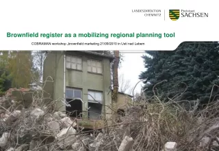
Brownfield register as a mobilizing regional planning tool. COBRAMAN workshop „brownfield marketing 21/09/2010 in Usti nad Labem.

E N D
Brownfield register as a mobilizing regional planning tool COBRAMAN workshop „brownfield marketing 21/09/2010 in Usti nad Labem
- Points of departure from a soil protection perspective - Points of departure from a regional administration´s view- Set-up and operation of the brownfield register
Points of departure from a soil protection perspective • German conference of Länder ministers for environment supports the idea to counter balance measures that increase soil permeability with interventions in nature. In specific cases, this can include demolition measures. (63th conference of Länder ministers for environment, Nov 04) • German conference of Länder ministers for spatial development agrees to the national sustainability strategy. One of its objective is the substantial reduction of land consumption by settlement and infrastructure until 2020. Settlement activities should concentrate on inner development of cities and municipalities. (36th conference of Länder ministers for spatial development, Jun 09) • Already from 2000 to 2006 Saxony earmarked substantial resources for funding quarter development and brownfield revitalisation by using ERDF funds. This earmarking was continued in the period 2007 to 2013, supplemented by the administrative regulation of the Saxon Ministry of Interior on revitalisation of brownfields in 2009. • On 28/04/09 an action programme was launched for reduction of land consumption in Saxony as main target of a sustainable development strategy. • The current governing coalition in Saxony agreed (1) to provide sufficient space for industrial settlements, (2) to reduce land consumption. (Coalition treaty Saxony, Sep 09). • The current governing coalition in Germany agreed to give priority to recycling of space and compaction of inner city areas over additional land consumption. Brownfield registers have to be improved. (Coalition treaty German Federation, Oct 09).
Development of population over land consumption in the regional state district Chemnitz 125 120 115 110 105 % 100 95 90 85 80 1993 1994 1996 2001 2002 2006 2009 1992 1995 1997 1998 1999 2000 2003 2004 2005 2007 2008 Population % Land consumption %
Points of departure from a regional administration´s view Brownfields are an important field of action because of building law relevance, environmental law relevance, relevance for municipal budgeting, relevance for spatial development, for economic-political implications, tourist relevance. - Urban regeneration old building quarters are prone to neglection, modernisation necessary - Urban conversion enhancing traditional urban regeneration, urban development has to be adapted to decreasing population and difficult economic framework conditions with permanent apartment vacancies - Interim uses Spaces currently out of use are not permanently re-directed to other uses because of lacking perspectives (e.g. demolition with interim greening) - Renaturation Conversion of vacant buildings and permanent brownfields by renaturation as upgrading measure
In awarenessofthesenecessitiesandoptions, • in responsibilityforfindingsolutions, and • in awareness, thatthesesolutionscannotbereachedwithoutpartners in municipalitiesandcounties • the regional workgroup „Brownfields“ • was founded in 2000 on initiative ofthepresident in thedistrict Chemnitz withfollowingtasks: • cross-sectoralandcross-borderbunching, • supportofrevitalisationofselectedbrownfields, • set-upof a databasewiththeobjectivetocompile, evaluate, anddevelopbrownfields • The brownfieldregister was developedas a computerisedtoolandimprovedfrom 2005 onwards. Itiscontinuouslyfedwithinternalinformationfromthe regional stateadministration, but also externalinformationfromthemedia. Further actors, especiallyeconomicdevelopmentagenciesand environmental administrationswereincluded in theworkgroup und theirdatainserted in thedatabase.
Advantages ofthebrownfieldregister forthe regional stateoffice: basisforassessmentandactions, e.g. fortargetedallocationoffundsas well asspatialdevelopmentrecommendations formunicipalities:sourceofinformationandbasisforactionregardingspatialplanningsandinvestments promotionofrevitalisationofbrownfields for potential byers: brownfieldscanbemarketed via a computer-basedsystemfordevelopmentagenciesand – ifreleased – also via internet(KWIS – Kommunales Wirtschafts-Informations-System) relevant informationforpublicplanningagencies, e.g. forcheckingsuitabilityascompensatingarea preciseinformation on landandbuidlings profoundinformation, incl. ownerandmunicipalcontactoption forowners: free-of-chargemarketingwithhighefficiency
Steps towards the brownfield register Continuous registering of brownfields from 2005 onwards using KWIS 2.7 currently 3924 datasets Promotion of municipal brownfield registers amongst others cities of Brand-Erbisdorf, Chemnitz, Freiberg, Plauen, Reichenbach/Vogtl. Import of municipal data in the KWIS 2.7 database of the regional state office Chemnitz Migration of all internal data from KWIS 2.7 into KWIS.net currently > 4232 Datensätze Latest development: consistency checks, supplementation, and additions of new data sets by the municipalities via the free-of-charge online tool KWIS.web Decision of municipality together with owner regarding marketing in internet
Ausblick Anleitung der Kommunen- und Landkreise im Umgang mit der Online-Ein-/Ausgabemaske (KWIS.web) Kontinuierliche Erweiterung und Pflege des Katasters durch die Gemeinden und Betreuung durch PG Brachen der Landesdirektion Stufenweise Vervollständigung der Datensätze auch durch die Projektgruppe als Informations- und Handlungsbasis im Hinblick auf Angaben zum Flächenverbrauch und zur Wiedereingliederung von Brachflächen in Wirtschafts- oder Naturkreislauf für Gemeinden, Landkreise und die Landesdirektion Gemeindeübergreifendes Informationsportal zum interkommunalen Interessensausgleich Schaffung fachlicher Grundlagen für dieBrachenbewertung in Hinblick auf Nach-nutzungsmöglichkeiten, insbesondere auf Grundlage der Erfahrungen des LfULG Schaffung einer rechnergestützten Bewertung der Brachflächen Erfassung / Verknüpfung der geographischen Lage im / mit dem KWIS Modellhafte Überführung des Kataster für die Arbeit im gesamten Land(vorrangige Maßnahme im sächsischen Handlungsprogramm zur Reduzierung der Flächeninanspruchnahme)
ZusammenfassungErfassen KWIS.net, KWIS.webBewerten Bündelungsfunktion für die vielfältigen Ansätze im DirektionsbezirkMobilisieren Zusammenstellung aller notwendigen Informationen für die Kommunen auf der LDC-Homepage Einbringung des gesamten Sachverstandes des LDC in die Lösung der Brachenproblematik