Download
1 / 21
210 likes | 306 Views
Understand river network formation, erosion processes, drainage density, and drainage patterns in geomorphology explained by Harry Williams. Learn about local and regional drainage patterns using examples.

E N D
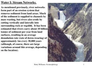
Water I: Stream Networks. As mentioned previously, river networks form part of an erosion system that removes sediment from land areas. Much of the sediment is supplied to channels by mass wasting, but rivers also erode by cutting vertically and laterally into surrounding rock or regolith. It has been estimated that rivers carry about 10 billion tonnes of sediment per year from land surfaces, resulting in an average denudation rate (rate of down-wearing) of approximately 1m every 30,000 years (although, of course, there are large variations around this average, depending on the location). Harry Williams, Geomorphology
Channel Networks. The distribution of channels forms a hierarchy of small headwater channels draining into progressively larger channels downstream. Harry Williams, Geomorphology
Most channel networks evolve by headward erosion, perhaps along rills and gullies, to the point where water and sediment supplied from the surrounding DRAINAGE BASIN (delimited by a DRAINAGE DIVIDE) can be efficiently removed. Harry Williams, Geomorphology
One question is how many channels will form within a drainage basin? When will the channel network stop growing? The concentration of channels within a drainage basin is measured by DRAINAGE DENSITY (total channel length/drainage basin area). Area: 2 square milesTotal channel length: 6 milesDrainage density: 3 miles/square mile Area: 2 square milesTotal channel length: 20 milesDrainage density: 10 miles/square mile Harry Williams, Geomorphology
In answer to the question, the drainage density depends on the minimum area required to supply sufficient run-off (Hortonian Overland Flow, Saturation Overland Flow, interflow) to a channel to maintain it against in-filling by mass wasting of its banks. The amount of run-off depends on climate, vegetation and surface infiltration rate; for example, in semi-arid areas, vegetation is sparse, surface infiltration is low and rainfall is often intense -> small area can produce New Mexico - high drainage density large amount of run-off -> large drainage density. In any climatic area, variations in factors such as slope, rock type and vegetation will result in local variations in drainage density. Harry Williams, Geomorphology
Drainage Patterns The actual pattern of channels usually reflects the regional geologic structure and topography: RADIAL: channelsdrain dome-shaped geologic structures or volcanic cones; the streams radiate out from the central high point. hills mountains cliffs ridges Harry Williams, Geomorphology
valleys RECTANGULAR - usually form where streams have exploited rectangular networks of joints in rocks such as granite. canyons deltas beaches Harry Williams, Geomorphology
TRELLIS - form on parallel outcrops of rocks of varying resistance; main streams occupy strike valleys; shorter tributaries drain intervening ridges and join main streams at approximately right angles. Harry Williams, Geomorphology
PARALLEL - main streams are all aligned in approximately the same direction; usually form where streams follow a regional slope. Regional slope Harry Williams, Geomorphology
DENDRITIC - a branching pattern, probably the most common, forms where rocks are fairly uniform or where there is no strong structural control on drainage patterns. Harry Williams, Geomorphology
Apart from influencing the regional drainage pattern, geology will also influence the location of individual streams within a drainage basin via the action of differential erosion -i.e. as the landscape is worn down by erosion, streams will naturally tend to occupy lines of weakness caused by different rock types, faults or joints, or slight variations in rock strength. Example: Regional And Local Drainage Patterns In The DFW Region. In Dallas County, the main stream is the Trinity River, which is a consequent stream (follows the regional slope to the southeast). Major tributaries of the Trinity (e.g.the Elm Fork) are usually subsequent streams occupying strike valleys. Harry Williams, Geomorphology
Village Creek is another subsequent stream occupying a strike valley formed in the Grayson Marl. Woodbine sandstone Harry Williams, Geomorphology
A PARALLEL stream network pattern has formed down the dipslope of the Austin Chalk cuesta. White Rock Escarpment Mountain Creek strike valley Austin Chalk cuesta dipslope Kau Kef Kwb LAB 2 Harry Williams, Geomorphology
In prominent strike valleys, such as Mountain Creek valley, TRELLIS patterns may develop. Harry Williams, Geomorphology
In Rockwall county, on an area of low gradient and uniform rock type, a DENDRITIC pattern has formed. Harry Williams, Geomorphology
Clearly there are many streams in this region - many of the "dips" in the landscape are therefore stream valleys resulting from stream erosion and hill slope erosion processes. Many of the hills are interfluves (drainage divide between two stream valleys) or more resistant rock outcrops which have been left standing higher by differential erosion (e.g. White Rock escarpment). Harry Williams, Geomorphology
In the Denton area, for example, many hills are outliers of resistant Woodbine Sandstone (masses of rock "cut off" from the main outcrop on the east side of town). Areas underlain by Woodbine Sandstone in Denton are easily recognized because they tend to be higher, covered by oak trees and have sandy soil, often exposed in road cuts (e.g. Southridge, TWU). Harry Williams, Geomorphology
Some of the outliers are Crawford Hill, Long Point, Pilot Knob to the southwest, the hills under Apogee Stadium, McKenna Park and (the former) Flow Hospital near the UNT campus. Harry Williams, Geomorphology
One of the implications of this is that Woodbine Sandstone, as well as other Upper Cretaceous rocks, once covered the Denton area; these rocks have been differentially eroded over the last 60 million years, resulting in the present-day landscape. How much rock has been eroded? This is uncertain, but estimates are in the range of 1000 - 1500 feet. OUTLIERS Harry Williams, Geomorphology