Download
1 / 4
40 likes | 58 Views
Explore GPS technology in hiking and navigation, from determining approximate locations with satellites to optimizing travel routes. Learn about the Traveling Salesperson Problem and other optimization challenges.

E N D
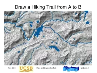
Draw a Hiking Trail from A to B A B Maps and Graphs: Sci/Tech
How GPS Works: The Measurements Satellites in known positions Where am I? Approximate location of moving GPS receiver determined from distance to satellites Fixed station is used to make the location info more precise Communication Moving GPS receiver Fixed Station Maps and Graphs: Sci/Tech
GPS-Guided Navigation You know where you are (GPS) and where you want to go (address) Roads form a known maze, stored on Google’s servers When there are multiple paths, you want the shortest/fastest path To determine which path is faster, dynamic congestion data may be used Maps and Graphs: Sci/Tech
The Traveling Salesperson Problem If the number on an edge represents travel distance, time, or cost, what is the shortest/fastest/cheapest tour of the six locations? A salesperson may want to visit all the locations A truck may have deliveries at all the locations Other Optimization Problems Assuming numbers shown are travel times for a fire truck in minutes, where is the best location for a single fire station? Where should fire stations be placed for a response time of 8 minutes? Maps and Graphs: Sci/Tech