Download
1 / 7
70 likes | 150 Views
Explore the power of natural energy in Ingram Valley through an interactive map highlighting the landscape formation, human influence, and renewable energy initiatives. Discover the captivating Linhope Spout waterfall and the centuries-old impact of erosion on the land. Witness the evolving relationship between nature and human activity, from ancient settlements to modern conservation efforts. Venture into the Northumberland National Park for a firsthand experience of the sustainable energy sources shaping this picturesque valley.

E N D
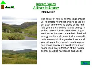
Ingram ValleyA Story in Energy Introduction The power of natural energy is all around us. Its effects might not always be visible but each time the wind blows or the rain falls you are witnessing natural energy in action; powerful and sustainable. If you want to see the awesome effect of natural energy on the environment all you need to do is venture into the great outdoors and you will see it for yourself. Just imagine how much energy we would have at our finger tips if only a fraction of this natural energy could be harnessed and used! Next
Ingram ValleyA Story in Energy Interactive Map This is a map of Ingram Valley in The Northumberland National Park. Ingram Valley and its surrounding areas provide an excellent example of the natural energy generated by the environment. Click on each photo on the map to find out more information about the formation of the landscape and mans influence on the effects of natural energy on the environment. Visit Ingram Valley Ingram Valley is a wonderful place to visit. Go for a walk, have a picnic and visit Linhope Spout, the largest and one of the finest waterfalls in the park. For more information on the area visit The Northumberland National Park web-site or contact the Ingram Visitors Centre using the details below. Web: www.northumberlandnationalpark.org.uk/linhopespout-lo.pdf Ingram Visitors Centre: (Tel) 01665 578890 Warning Hill walking is an adventurous activity that should only be conducted under the supervision of a suitably qualified or experienced person. This map should be used as reference material only and must not be used in place of an appropriate map of the area (e.g. OS Explorer – The Cheviot Hills Sheet OL16). Next
Ingram Valley A Story in Energy (Click on a picture to find out more) Linhope Spout Finish Hartside Start Road / Track Trail Trees Buildings River
Ingram ValleyA Story in Energy • Natural Formation of the Land • The hills in the Cheviots were all formed by the natural power of a volcano 380 million years ago. • The shape of the valleys were produced by glaciers over 2 million years ago during the last Ice Age • The shape of the land is continually changing caused by the natural power of the rivers, burns, wind, rain and snow that carve out the land around them on a daily basis. • This continuous process of erosion is a slow process that is all but invisible to the naked eye for many years. A visual depiction of this process can be seen on a smaller scale by looking at the cracks and pot holes that appear in the roads and lanes of the valley on a regular basis. U-Shaped Valley Back to Map Weather Damage to Road
Ingram ValleyA Story in Energy • Water Power • Linhope Spout is a 60foot (18m) chute of water which lands in a plunge pool 6ft (2m) wide and 16ft (5m) deep. • The surrounding landscape is made up of Granite, a very hard Igneous rock type. • Over thousands of years the hard Granite rock has been cut away by the sheer force of the water as it pours over the edge providing a very dramatic yet visual depiction of the natural kinetic energy contained in flowing water. Linhope Spout Water Fall Back to Map
Ingram ValleyA Story in Energy • The Human Effect • People were first recorded living in and around Ingram Valley during the Mesolithic Period (8000-4000BC). • Before the Valley was inhabited it was covered in dense deciduous woodland, like much of the rest of Britain. This woodland was slowly cut down and the land dug up, by settlers in the valley, to make way for farm land. • The woodland which covered vast areas of Ingram Valley helped to protect the landscape from the harsh impact of the elements. • With the trees slowly disappearing from the landscape the hills and valley’s were left open to a much faster rate of erosion from wind, rain, snow and ice. • Look around you and see for your own eyes the effect of the elements on the bare landscape. Iron Age Settlement (800BC-79AD) Natural Land Erosion Back to Map
Ingram ValleyA Story in Energy • The Human Effect Continued • Throughout Ingram Valley there are now small man made forest plantations. Not only do the trees protect the landscape to slow the rate of erosion but they are also used to help provide a renewable energy resource and boost the local economy. • Croyes are another man made erosion control measure in use in Ingram Valley. They are used along the embankments of the River Breamish to slow down the rate of river erosion to help protect the surrounding buildings and farms from the force of the water. Forest Plantation Croyes Along River Breamish Back to Map