Download
1 / 9
90 likes | 191 Views
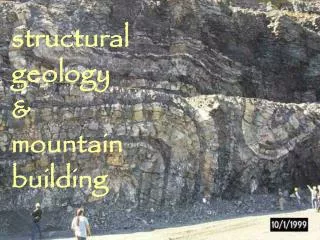
Building Site Geology Auke Bay, Alaska. April 22-23, 2005 Geol 104 Lab 10. Waypoints Anderson Beach, Roadside Auke Bay, and GPS class Campus Points. Smugglers’ Cove Photos by Brandon W. and Cathy C. Fox Farm Road Photos by Brandon W. and Cathy C. Climber’s Cliff

E N D
Building Site GeologyAuke Bay, Alaska April 22-23, 2005 Geol 104 Lab 10
Waypoints Anderson Beach, Roadside Auke Bay, and GPS class Campus Points
Smugglers’ Cove Photos by Brandon W. and Cathy C.
Fox Farm Road Photos by Brandon W. and Cathy C.
Climber’s Cliff Photos by Brandon W. and Cathy C.
Gard’s Beach Fritz Cove Rd Photos by Brandon W. and Cathy C.
Auke Bay School Photos by Brandon W.
UAS NW Back Loop Road Entrance Near Egan Library Photo by Brandon W.
Wave Cut Terraces • Around Auke Bay: • Holocene Uplift • Glacial Rebound • Tectonic Crustal Change