Download
1 / 35
350 likes | 438 Views
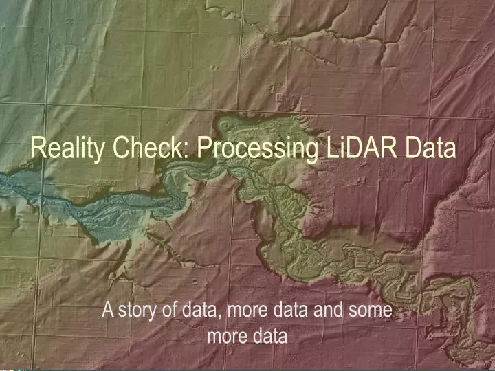
Reality Check: Processing LiDAR Data. A story of data, more data and some more data. Red River of the North. Red River of the North. Red River of the North. Red River of the North. Introduction and Background. FEMA Grant to DNR in 2006

E N D
Reality Check: Processing LiDAR Data A story of data, more data and some more data
Introduction and Background • FEMA Grant to DNR in 2006 • Create a high resolution Digital Elevation Model for Floodplain Mapping in the Red River Valley • Partnered with • Clay County • Mn/DOT • Norman County • White Earth Reservation • Wild Rice Watershed District
Background • Red River Watershed • 17,700 Square Miles (Minnesota only) • LiDAR Collect Area (red outline) • 3663 Square Miles
Background • Data Specifications • Vertical Accuracy • 12 cm RMSE • Capabable of supporting 1.2’ contour generation • 15 cm RMSE • Capable of supporting 1.7’ contour generation • Horizontal Accuracy • 0.5 meters RMSE • 1 meter nominal point spacing
Background • Data to be delivered • All LiDAR Points • Bare Earth Points • Bare Earth Grid • Building Points • Vegetation Points • Intensity Imagery • Edge of water break lines • Used to enforce flat water areas….
Delivery Formats… • LAS – ASPRS LiDAR Exchange Format • Binary, Open standard, not vendor specific • Stores a variety of point information • Number of returns • Return Number • Intensity • X,Y, Z values • Scan Direction • Classification • Scan Angle Rank • GPS Time
Delivery Formats • ASCII Comma-delimeted • Very generic format • Digested by most any software • Limited amount of point information available • x, y, z • Large because no compression • Raster Grid • 1 meter resolution created from bare earth points • Generic and portable binary format • Integer format, centimeter Z-Values
Working with LiDAR Data • LiDAR datasets tend to be very large • LAS Format • All Returns – 7 million points, 100 mb / square mile • Bare Earth – 3 million points, 45 mb / square mile • ASCII Format • All Points – 4 million points, 75 mb / square mile • Bare Earth – 3 million points, 73 mb / square mile • Grid Format • 2.8 mb / square mile in integer format • 11.2 mb / square mile in floating point format
1.02 meters Data volume = high density 90 meters
Now for some math…. • 1 sq mile = 296mb • 3663 sq miles = 1,084,248 mb • Just over 1 gb worth of data for the project area! • Implications? • Lot’s of horsepower, er hertz-power • Lot’s of disk space • Lot’s of staff-time to copy, handle and process data • Lot’s of network capability for Web based delivery
Accuracy • LiDAR has the capacity to collect very high accuracy data • Depends on the flight height and the mission parameters • Increasing accuracy = Increasing Costs! • Limitation is the positional accuracy of the airborne GPS system
Accuracy • Validated the project data deliverables for a pilot project area of 100 square miles • Twenty-four control points captured by Mn/DOT survey crews • Accuracy proved to be very good. • Two sites were removed from the assessment • One was in a swamp • wet in spring, dry during survey • One was just outside the study area
Accuracy Assessment 13.4 cm * 1.96 = 26 cm at the 95% confidence level Assumptions: Normal Distribution Average of zero ding, ding ding ding
LiDAR Derived Products • What Data Do People Use? • Primary use products • Contours • Raster Digital Elevation Model • Most users don’t bother with the raw LiDAR data • Not a lot of tools available but this list is growing • ArcGIS extensions are now available to read LAS format LiDAR data • Derived products from raw LiDAR is a growing research field
Creating Contours • Contours are typically created from a raster DEM • Contours don’t always look visually appealing • Jagged lines that may wrap on themselves • Smoothing the DEM can help • 3x3 averaging filter works well • Makes the interpolation routine work harder • Commonly called Neighborhood analysis
Creating Contours…. Non-filtered DEM Filtered DEM 400’ 1’ contours on shaded relief
Contours….. Difference surface of Original – Smoothed DEM Maximum Difference 0.9 feet
Visualization • Lidar data can be visualized a number of ways • Shaded Relief images can reveal very subtle relief • Especially with high detail data • Helpful for data validation and looking for anomalies and errors in the data • 3-Dimensional viewing • Cross-sections • Contour generation
Lessons Learned • Use a Tiling Scheme of Your Choice • PLS Section boundaries work well • Validate the data using for a small pilot area • Saves you and the vendor time if there are problems • Do an independent accuracy assessment! • You might be surprised at what you find • Smoothed DEMs generate smooth contours