Download
1 / 18
180 likes | 335 Views
Kinematics of Super Tuesday Storms. Todd Murphy and Kevin Knupp University of Alabama in Huntsville. Outline. Introduction Event overview 2 cases: KNQA and KOHX Data and Methodology Synthetic dual-Doppler (SDD) wind retrieval Thermodynamic Retrieval Results Conclusions SDD technique

E N D
Kinematics of Super Tuesday Storms Todd Murphy and Kevin Knupp University of Alabama in Huntsville
Outline • Introduction • Event overview • 2 cases: KNQA and KOHX • Data and Methodology • Synthetic dual-Doppler (SDD) wind retrieval • Thermodynamic Retrieval • Results • Conclusions • SDD technique • Future work
Introduction • The supercell thunderstorm is one phenomena where research has benefited from multiple-Doppler wind retrievals and various thermodynamic retrieval schemes. • However, at least two Doppler radars are often not available. • Peace et al. (1969) was the first to suggest using single Doppler data collected during two time periods to perform wind retrievals – this method has since become known as the synthetic dual-Doppler (SDD) technique. • Has not been widely used on convective storms due to limitations of the technique.
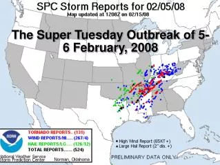
Introduction • The Super Tuesday outbreak of 5-6 Feb 2008, provided several cases where a SDD analysis might be successfully applied. • Two cases with differing levels of success will be presented. • Main Objective: • Examine variability on storm structure in an outbreak this large. • Thermodynamic retrievals were performed to determine the dominant updraft forcing mechanism. • Secondary Objective: • Explore viability on using the SDD technique on supercell thunderstorms.
Case 2 Case 1 Event Overview Location of cases relative to the event. RUC sounding centered on Nashville for 0700 UTC (Case 2).
Base reflectivity @ 0.9° from 2300 to 0050 UTC Case 1 - KNQA • Developed from a cluster of thunderstorms that initiated in NE Louisiana and SE Arkansas • Produced an EF2 tornado as it moved into TN, just north of Southaven, MS • Went on to produce a long track EF3 and the EF4 tornado that devastated Union University near Jackson, TN • Best SDD analyses came between 2350 and 0020 UTC, when the mesocyclone passed KNQA at a distance of 25-38 km • Storm motion was from 230° at 26 ms-1
Base reflectivity @ 0.9° from 0616 UTC to 0751 UTC Case 2 - KOHX • Developed from a cluster of cells in north Mississippi • Produced several EF0 tornadoes as it moved to the northeast, towards Nashville • Best SDD analyses came between 0650 and 0716 UTC, when the mesocyclone passed KOHX at a distance of 16-25 km • Storm motion was from 242° at 24 ms-1
Geometry of the (synthetic) dual-Doppler technique SDD Wind Retrieval • Technique described in detail by Bluestein and Hazen (1989) and Klimowski and Marwitz (1992) • Follows conventional dual-Doppler geometry (Lhermitte and Miller 1970) and uses the common dual-Doppler software, CEDRIC (Mohr et al. 1986) • Requirements/Assumptions: • Storm-motion must parallel radar site/synthetic baseline at a relatively close distance • The storm must move quick enough so that it goes through at least 30° of radar azimuth • Velocity fields can not change significantly between volume scans (quasi-steady-state assumption)
Steadiness of supercells first estimated by visually comparing volume scans and further quantified by a correlation analysis of radar variables • Main source of error is changes in velocity fields between volume scans • Error can also be introduced through uncertainties in calculating the storm-motion vector, which is used to find the radar baseline through cΔt where c is storm speed and Δts is time between volume scans (baseline ~ 30 km for both cases) • Visual comparison of case 1 showed a supercell slightly strengthening between volume scans. Correlation analysis yielded a correlation coefficient (r) of 0.4 - 0.7 below 5 km • Case 2 – did not change significantly; r value of 0.7 - 0.9 below 6 km
Thermodynamic Retrieval • Method pioneered by Gal-Chen (1978) and modified by others (Hane et al. 1981; Pasken and Lin 1982; Brandes 1984; Hane and Ray 1985) • Rearrange horizontal momentum equations to solve for pressure where “known” quantities F and G come from the horizontal wind field • Resulting Poisson equation can only be solved using a least squares solution and is subject to Neumann boundary conditions • θv, qc, qr found using a sounding from each location • Assumes ice free cloud, so presence of hail introduces error
Results – Case 1 SDD analyses, storm relative flow at 1.5 (left) and 4.0 (right) km Vertical motion at 1.5 (left) and 4.0 (right) km. Warm colors > 0 ms-1; cool colors < 0 ms-1; contour interval 10 ms-1 Peaks at 50 ms-1 at 4.0 km
Pressure perturbation at 1.5 (left) and 4.0 (right) km. Warm colors > 0 hPa; cool colors < 0 hPa; contour interval 0.5 hPa. Attains local minima of -3.0 hPa at 4.0 km. Buoyancy deviation at 1.5 (left) and 4.0 (right) km. Warm colors > 0°; cool colors < 0°; contour interval 1°. Local maximum greater than 4° reached at 4.0 km.
Results – Case 2 SDD analyses, storm relative flow at 1.5 (left) and 3.0 (right) km Vertical motion at 1.5 (left) and 3.0 (right) km. Warm colors > 0 ms-1; cool colors < 0 ms-1; contour interval 10 ms-1 Peaks at 34.5 ms-1 at 3.0 km
Pressure perturbation at 1.5 (left) and 3.0 (right) km. Warm colors > 0 hPa; cool colors < 0 hPa; contour interval 0.5 hPa Attains local minima of -3.0 hPa at 3.0 km. Buoyancy deviation at 1.5 (left) and 3.0 (right) km. Warm colors > 0°; cool colors < 0°; contour interval 1° Local maximum near 2.5° reached at 3.0 km.
Case 1 vertical cross section taken at x = 19.5 km Strong updraft on southern storm flank, but erroneous flows in northern part of storm Case 2 vertical cross section taken at x = -21 km Strong updraft on southern storm flank
Conclusions • Given the visual comparison of volume scans, correlation analysis, and actual results from the SDD analyses, case 2 appears to contain less error. • If a subjective quality score had to be given, case 2 would rank 4/5 whereas case 1 would be 2/5. • SDD technique captured the mesocyclone of case 1 fairly well, however, due to the evolving nature of this supercell, errors are unavoidable. • Case 2 demonstrates how well the SDD technique can work IF the requirements are met: • quasi-steady-state • move through at least 30° of radar azimuth • propagate parallel to the radar site at a relatively close distance • Often difficult for supercells to meet just one of these requirements – uniqueness of case 2.
Conclusions • Consider case 1 reliable enough for comparison. • Case 2 was smaller and not as strong (updraft of 34.5 ms-1 @ 3.0 km vs. 50 ms-1 at 4.0 km). • Case 2 was in a high shear-low(er) cape environment compared to the first. • Implications of such a low-level updraft maximum on low-level vorticity stretching. • Buoyancy deviations of case 1 were greater (more than 4°), possibly leading to greater buoyancy forcing. • Magnitude of pressure perturbations within the mesocyclones (-3.0 hPa) were similar, but different structures • Environmental differences played a significant role in their development.
Future Work • Examine other storms from a single Doppler viewpoint to put these in perspective. • More SDD analyses. • VAD analyses will be used to reveal changes in SRH during storm passage and details of outflow. • More robust thermodynamic retrievals. • Eventually, a high resolution numerical simulation will be used for further comparisons of SDD analyses and thermodynamic retrievals.