Download

1 / 27
270 likes | 456 Views
http://pubs.usgs.gov/gip/dynamic/slabs.html. http://pubs.usgs.gov/gip/dynamic/continents.html. http://pubs.usgs.gov/gip/dynamic/inside.html. http://pubs.usgs.gov/gip/dynamic/Farallon.html. http://pubs.usgs.gov/gip/dynamic/baseball.html. Magnetic striping.

E N D
Magnetic striping http://pubs.usgs.gov/gip/dynamic/developing.html
Four types of plate boundaries: Divergent boundaries -- where new crust is generated as the plates pull away from each other. Convergent boundaries -- where crust is destroyed as one plate dives under another. Transform boundaries -- where crust is neither produced nor destroyed as the plates slide horizontally past each other. Plate boundary zones -- broad belts in which boundaries are not well defined and the effects of plate interaction are unclear. http://pubs.usgs.gov/gip/dynamic/understanding.html
Divergent boundaries http://pubs.usgs.gov/gip/dynamic/understanding.html
Map of East Africa showing some of the historically active volcanoes (red triangles) and the Afar Triangle (shaded, center) -- a so-called triple junction (or triple point), where three plates are pulling away from one another: the Arabian Plate, and the two parts of the African Plate (the Nubian and the Somalian) splitting along the East African Rift Zone. http://pubs.usgs.gov/gip/dynamic/East_Africa.html
Transform boundaries http://pubs.usgs.gov/gip/dynamic/understanding.html
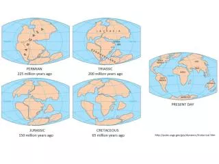
http://pubs.usgs.gov/gip/dynamic/Pangaea.html http://pubs.usgs.gov/gip/dynamic/tsunamis.html
References and Resources “This Dynamic Earth: The Story of Plate Tectonics” W. JacquelyneKious& Robert I. Tilling http://pubs.usgs.gov/gip/dynamic/dynamic.html This Dynamic Planet (interactive world map) http://mineralsciences.si.edu/tdpmap/ This Dynamic Planet: A Teaching Companion http://volcanoes.usgs.gov/about/edu/dynamicplanet/ Plate Tectonics Animations http://www.nature.nps.gov/geology/usgsnps/animate/pltecan.html
http://www.seos-project.eu/modules/oceancurrents/oceancurrents-c02-p03.htmlhttp://www.seos-project.eu/modules/oceancurrents/oceancurrents-c02-p03.html