Download
1 / 7
70 likes | 212 Views
The GEOSS Portfolio for Science and Technology Produced by ST0902 Featuring: Agriculture: Geo-wiki.org - Crowdsourcing to improve Landcover Validation.

E N D
The GEOSS Portfolio for Science and TechnologyProduced by ST0902Featuring:Agriculture: Geo-wiki.org - Crowdsourcing to improve Landcover Validation
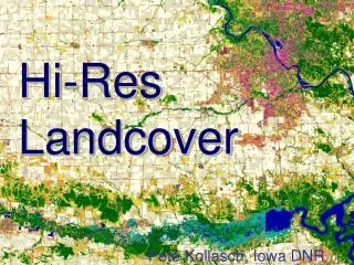
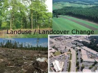
Since large differences occur between existing global land cover maps, current ecosystem and land-use science lacks crucial accurate data (e.g. to determine the potential of additional agricultural land available to grow crops in Africa). Volunteers are asked to review hotspot maps of global land cover disagreement and determine, based on what they actually see in Google Earth and their local knowledge, if the land cover maps are correct or incorrect and provide the correct land cover information on the pixel level Their input is recorded in a database, along with uploaded photos, to be used in the future as validation sites and possibly for the creation of a new and improved global land cover map. Geo-wiki.org - Crowdsourcing to improve Landcover Validation
The Geo-wiki.org currently compares three satellite derived land cover datasets (MODIS 500m product, Globcover version 2, GLC-2000 Version1. Disagreement is analysed based on a conservative approach using one a one to many mapping approach of land cover categories (see Fritz and See, GCB, 2008) Geo-wiki.org - Crowdsourcing to improve Landcover Validation
The geo-wiki.org has been designed to further advance the study of land cover validation. It is now possible with only an internet connection, to simultaneously view and visually analyze land cover anywhere on the planet. For example if you go to Sri Lanka and activate the overall disagreement button, areas of high forest and cropland disagreement appear (see Figure) in red. Geo-wiki.org - Crowdsourcing to improve Landcover Validation Red Pixels indicate areas of high disagreement between MODIS and GlobCover cropland classification
Geo-wiki.org - Crowdsourcing to improve Landcover Validation Volunteers are asked to determine, based on what they actually see in Google Earth and their local knowledge, if the land cover maps are correct or incorrect and provide the correct land cover information on the pixel level. The Land cover class is directly read from a database and shown.
Geo-wiki.org - Crowdsourcing to improve Landcover Validation Brazil, Pernambuco 9 ° South 40 ° West, West Direction The current geo-wiki land cover validation tool is directly linked to the Global Degree Confluence Project and Panoramio. Volunteers can additionally upload pictures (any URL or link to the confluence project, http://confluence.org/) and using images from Google Earth. Example is confluence point in Sri Lanka (8°N 81°E,visit #1)
Geo-wiki.org - Crowdsourcing to improve Landcover Validation For more information please ContactSteffen Fritz: fritz@iiasa.ac.atAdditional information on the geo-wiki:http://www.mdpi.com/2072-4292/1/3/345